 Add to Chrome
 Add to Firefox
 Add to Edge
OpenEarthSensing: Large-Scale Fine-Grained Benchmark for Open-World Remote Sensing
Paper and Code
Feb 28, 2025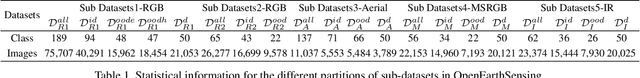
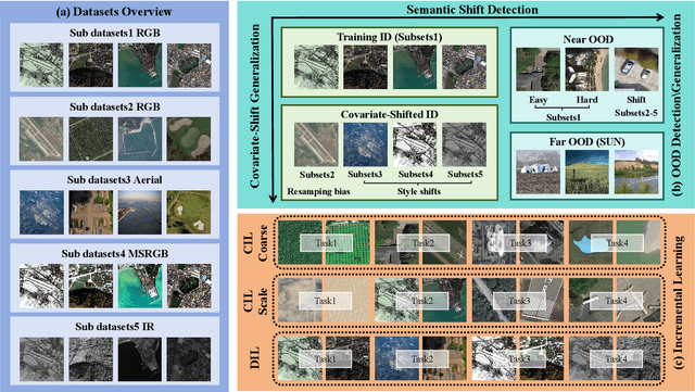
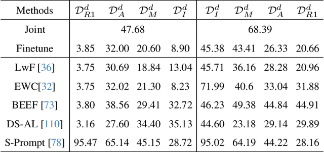
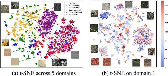
In open-world remote sensing, deployed models must continuously adapt to a steady influx of new data, which often exhibits various shifts compared to what the model encountered during the training phase. To effectively handle the new data, models are required to detect semantic shifts, adapt to covariate shifts, and continuously update themselves. These challenges give rise to a variety of open-world tasks. However, existing open-world remote sensing studies typically train and test within a single dataset to simulate open-world conditions. Currently, there is a lack of large-scale benchmarks capable of evaluating multiple open-world tasks. In this paper, we introduce OpenEarthSensing, a large-scale fine-grained benchmark for open-world remote sensing. OpenEarthSensing includes 189 scene and objects categories, covering the vast majority of potential semantic shifts that may occur in the real world. Additionally, OpenEarthSensing encompasses five data domains with significant covariate shifts, including two RGB satellite domians, one RGB aerial domian, one MS RGB domian, and one infrared domian. The various domains provide a more comprehensive testbed for evaluating the generalization performance of open-world models. We conduct the baseline evaluation of current mainstream open-world tasks and methods on OpenEarthSensing, demonstrating that it serves as a challenging benchmark for open-world remote sensing.