Xianping Ma
Kolmogorov-Arnold Network for Remote Sensing Image Semantic Segmentation
Jan 13, 2025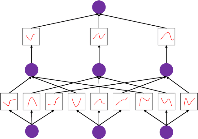


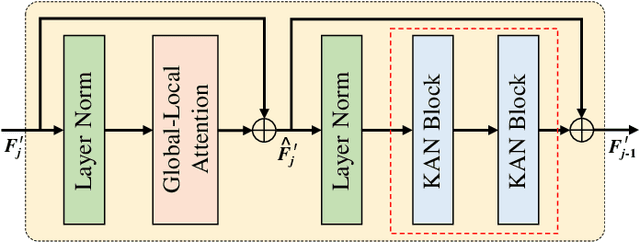
Abstract:Semantic segmentation plays a crucial role in remote sensing applications, where the accurate extraction and representation of features are essential for high-quality results. Despite the widespread use of encoder-decoder architectures, existing methods often struggle with fully utilizing the high-dimensional features extracted by the encoder and efficiently recovering detailed information during decoding. To address these problems, we propose a novel semantic segmentation network, namely DeepKANSeg, including two key innovations based on the emerging Kolmogorov Arnold Network (KAN). Notably, the advantage of KAN lies in its ability to decompose high-dimensional complex functions into univariate transformations, enabling efficient and flexible representation of intricate relationships in data. First, we introduce a KAN-based deep feature refinement module, namely DeepKAN to effectively capture complex spatial and rich semantic relationships from high-dimensional features. Second, we replace the traditional multi-layer perceptron (MLP) layers in the global-local combined decoder with KAN-based linear layers, namely GLKAN. This module enhances the decoder's ability to capture fine-grained details during decoding. To evaluate the effectiveness of the proposed method, experiments are conducted on two well-known fine-resolution remote sensing benchmark datasets, namely ISPRS Vaihingen and ISPRS Potsdam. The results demonstrate that the KAN-enhanced segmentation model achieves superior performance in terms of accuracy compared to state-of-the-art methods. They highlight the potential of KANs as a powerful alternative to traditional architectures in semantic segmentation tasks. Moreover, the explicit univariate decomposition provides improved interpretability, which is particularly beneficial for applications requiring explainable learning in remote sensing.
MANet: Fine-Tuning Segment Anything Model for Multimodal Remote Sensing Semantic Segmentation
Oct 15, 2024


Abstract:Multimodal remote sensing data, collected from a variety of sensors, provide a comprehensive and integrated perspective of the Earth's surface. By employing multimodal fusion techniques, semantic segmentation offers more detailed insights into geographic scenes compared to single-modality approaches. Building upon recent advancements in vision foundation models, particularly the Segment Anything Model (SAM), this study introduces a novel Multimodal Adapter-based Network (MANet) for multimodal remote sensing semantic segmentation. At the core of this approach is the development of a Multimodal Adapter (MMAdapter), which fine-tunes SAM's image encoder to effectively leverage the model's general knowledge for multimodal data. In addition, a pyramid-based Deep Fusion Module (DFM) is incorporated to further integrate high-level geographic features across multiple scales before decoding. This work not only introduces a novel network for multimodal fusion, but also demonstrates, for the first time, SAM's powerful generalization capabilities with Digital Surface Model (DSM) data. Experimental results on two well-established fine-resolution multimodal remote sensing datasets, ISPRS Vaihingen and ISPRS Potsdam, confirm that the proposed MANet significantly surpasses current models in the task of multimodal semantic segmentation. The source code for this work will be accessible at https://github.com/sstary/SSRS.
PPMamba: A Pyramid Pooling Local Auxiliary SSM-Based Model for Remote Sensing Image Semantic Segmentation
Sep 10, 2024
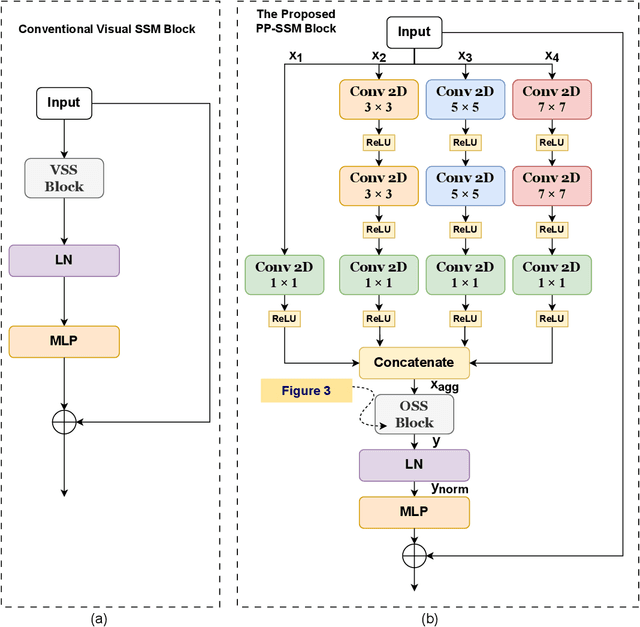

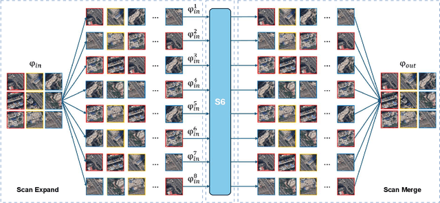
Abstract:Semantic segmentation is a vital task in the field of remote sensing (RS). However, conventional convolutional neural network (CNN) and transformer-based models face limitations in capturing long-range dependencies or are often computationally intensive. Recently, an advanced state space model (SSM), namely Mamba, was introduced, offering linear computational complexity while effectively establishing long-distance dependencies. Despite their advantages, Mamba-based methods encounter challenges in preserving local semantic information. To cope with these challenges, this paper proposes a novel network called Pyramid Pooling Mamba (PPMamba), which integrates CNN and Mamba for RS semantic segmentation tasks. The core structure of PPMamba, the Pyramid Pooling-State Space Model (PP-SSM) block, combines a local auxiliary mechanism with an omnidirectional state space model (OSS) that selectively scans feature maps from eight directions, capturing comprehensive feature information. Additionally, the auxiliary mechanism includes pyramid-shaped convolutional branches designed to extract features at multiple scales. Extensive experiments on two widely-used datasets, ISPRS Vaihingen and LoveDA Urban, demonstrate that PPMamba achieves competitive performance compared to state-of-the-art models.
Frequency Decomposition-Driven Unsupervised Domain Adaptation for Remote Sensing Image Semantic Segmentation
Apr 06, 2024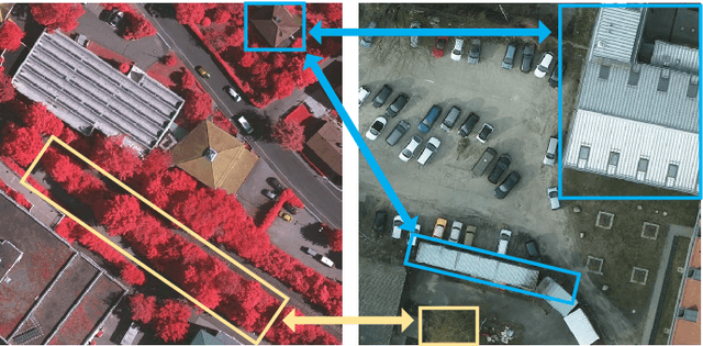
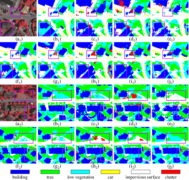
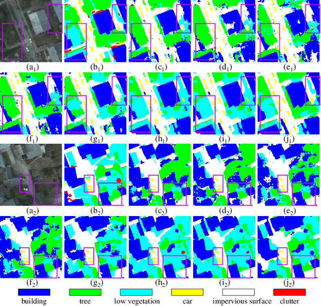
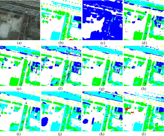
Abstract:Cross-domain semantic segmentation of remote sensing (RS) imagery based on unsupervised domain adaptation (UDA) techniques has significantly advanced deep-learning applications in the geosciences. Recently, with its ingenious and versatile architecture, the Transformer model has been successfully applied in RS-UDA tasks. However, existing UDA methods mainly focus on domain alignment in the high-level feature space. It is still challenging to retain cross-domain local spatial details and global contextual semantics simultaneously, which is crucial for the RS image semantic segmentation task. To address these problems, we propose novel high/low-frequency decomposition (HLFD) techniques to guide representation alignment in cross-domain semantic segmentation. Specifically, HLFD attempts to decompose the feature maps into high- and low-frequency components before performing the domain alignment in the corresponding subspaces. Secondly, to further facilitate the alignment of decomposed features, we propose a fully global-local generative adversarial network, namely GLGAN, to learn domain-invariant detailed and semantic features across domains by leveraging global-local transformer blocks (GLTBs). By integrating HLFD techniques and the GLGAN, a novel UDA framework called FD-GLGAN is developed to improve the cross-domain transferability and generalization capability of semantic segmentation models. Extensive experiments on two fine-resolution benchmark datasets, namely ISPRS Potsdam and ISPRS Vaihingen, highlight the effectiveness and superiority of the proposed approach as compared to the state-of-the-art UDA methods. The source code for this work will be accessible at https://github.com/sstary/SSRS.
RS3Mamba: Visual State Space Model for Remote Sensing Images Semantic Segmentation
Apr 03, 2024Abstract:Semantic segmentation of remote sensing images is a fundamental task in geoscience research. However, there are some significant shortcomings for the widely used convolutional neural networks (CNNs) and Transformers. The former is limited by its insufficient long-range modeling capabilities, while the latter is hampered by its computational complexity. Recently, a novel visual state space (VSS) model represented by Mamba has emerged, capable of modeling long-range relationships with linear computability. In this work, we propose a novel dual-branch network named remote sensing images semantic segmentation Mamba (RS3Mamba) to incorporate this innovative technology into remote sensing tasks. Specifically, RS3Mamba utilizes VSS blocks to construct an auxiliary branch, providing additional global information to convolution-based main branch. Moreover, considering the distinct characteristics of the two branches, we introduce a collaborative completion module (CCM) to enhance and fuse features from the dual-encoder. Experimental results on two widely used datasets, ISPRS Vaihingen and LoveDA Urban, demonstrate the effectiveness and potential of the proposed RS3Mamba. To the best of our knowledge, this is the first vision Mamba specifically designed for remote sensing images semantic segmentation. The source code will be made available at https://github.com/sstary/SSRS.
Adaptive Semantic-Enhanced Denoising Diffusion Probabilistic Model for Remote Sensing Image Super-Resolution
Mar 17, 2024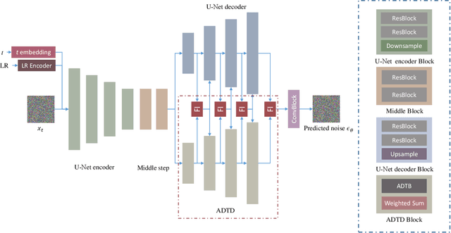
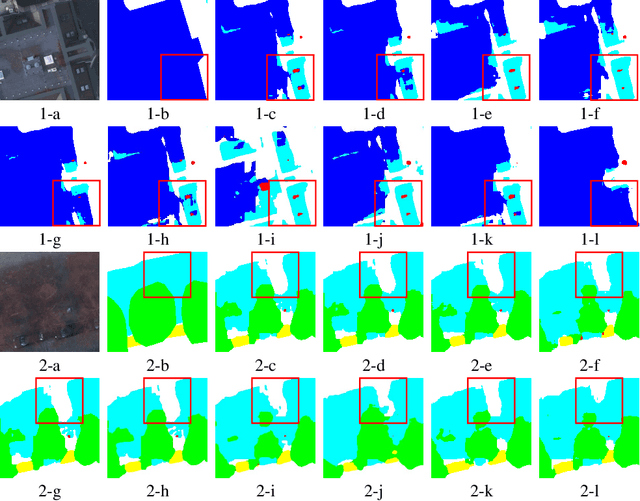
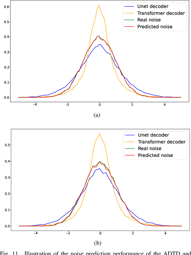
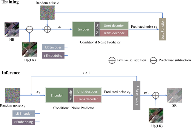
Abstract:Remote sensing image super-resolution (SR) is a crucial task to restore high-resolution (HR) images from low-resolution (LR) observations. Recently, the Denoising Diffusion Probabilistic Model (DDPM) has shown promising performance in image reconstructions by overcoming problems inherent in generative models, such as over-smoothing and mode collapse. However, the high-frequency details generated by DDPM often suffer from misalignment with HR images due to the model's tendency to overlook long-range semantic contexts. This is attributed to the widely used U-Net decoder in the conditional noise predictor, which tends to overemphasize local information, leading to the generation of noises with significant variances during the prediction process. To address these issues, an adaptive semantic-enhanced DDPM (ASDDPM) is proposed to enhance the detail-preserving capability of the DDPM by incorporating low-frequency semantic information provided by the Transformer. Specifically, a novel adaptive diffusion Transformer decoder (ADTD) is developed to bridge the semantic gap between the encoder and decoder through regulating the noise prediction with the global contextual relationships and long-range dependencies in the diffusion process. Additionally, a residual feature fusion strategy establishes information exchange between the two decoders at multiple levels. As a result, the predicted noise generated by our approach closely approximates that of the real noise distribution.Extensive experiments on two SR and two semantic segmentation datasets confirm the superior performance of the proposed ASDDPM in both SR and the subsequent downstream applications. The source code will be available at https://github.com/littlebeen/ASDDPM-Adaptive-Semantic-Enhanced-DDPM.
DF4LCZ: A SAM-Empowered Data Fusion Framework for Scene-Level Local Climate Zone Classification
Mar 14, 2024Abstract:Recent advancements in remote sensing (RS) technologies have shown their potential in accurately classifying local climate zones (LCZs). However, traditional scene-level methods using convolutional neural networks (CNNs) often struggle to integrate prior knowledge of ground objects effectively. Moreover, commonly utilized data sources like Sentinel-2 encounter difficulties in capturing detailed ground object information. To tackle these challenges, we propose a data fusion method that integrates ground object priors extracted from high-resolution Google imagery with Sentinel-2 multispectral imagery. The proposed method introduces a novel Dual-stream Fusion framework for LCZ classification (DF4LCZ), integrating instance-based location features from Google imagery with the scene-level spatial-spectral features extracted from Sentinel-2 imagery. The framework incorporates a Graph Convolutional Network (GCN) module empowered by the Segment Anything Model (SAM) to enhance feature extraction from Google imagery. Simultaneously, the framework employs a 3D-CNN architecture to learn the spectral-spatial features of Sentinel-2 imagery. Experiments are conducted on a multi-source remote sensing image dataset specifically designed for LCZ classification, validating the effectiveness of the proposed DF4LCZ. The related code and dataset are available at https://github.com/ctrlovefly/DF4LCZ.
SAM-Assisted Remote Sensing Imagery Semantic Segmentation with Object and Boundary Constraints
Dec 05, 2023


Abstract:Semantic segmentation of remote sensing imagery plays a pivotal role in extracting precise information for diverse down-stream applications. Recent development of the Segment Anything Model (SAM), an advanced general-purpose segmentation model, has revolutionized this field, presenting new avenues for accurate and efficient segmentation. However, SAM is limited to generating segmentation results without class information. Consequently, the utilization of such a powerful general vision model for semantic segmentation in remote sensing images has become a focal point of research. In this paper, we present a streamlined framework aimed at leveraging the raw output of SAM by exploiting two novel concepts called SAM-Generated Object (SGO) and SAM-Generated Boundary (SGB). More specifically, we propose a novel object loss and further introduce a boundary loss as augmentative components to aid in model optimization in a general semantic segmentation framework. Taking into account the content characteristics of SGO, we introduce the concept of object consistency to leverage segmented regions lacking semantic information. By imposing constraints on the consistency of predicted values within objects, the object loss aims to enhance semantic segmentation performance. Furthermore, the boundary loss capitalizes on the distinctive features of SGB by directing the model's attention to the boundary information of the object. Experimental results on two well-known datasets, namely ISPRS Vaihingen and LoveDA Urban, demonstrate the effectiveness of our proposed method. The source code for this work will be accessible at https://github.com/sstary/SSRS.
A Generative Change Detection Model Based on Difference-Feature Guided DDPM
Jun 17, 2023
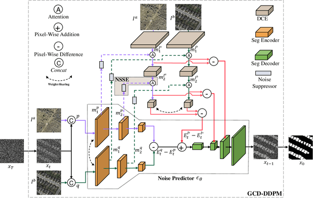


Abstract:Deep learning (DL) approaches, such as CNN and Transformer networks, have shown promise in bitemporal change detection (CD). However, these approaches have limitations in capturing long-range dependencies and incorporating 2D structure and spatial local information, resulting in inaccurate CD maps with discerning edges. To overcome these limitations, this paper presents a novel end-to-end DDPM-based model called change-aware diffusion model (CADM), which introduces three key innovations. Firstly, CADM directly generates CD maps as a generation model. It leverages variational inference, a powerful technique for learning complex probabilistic models, to facilitate the gradual learning and refinement of the model's data representation. This enables CADM to effectively distinguish subtle and irregular buildings or natural scenes from the background. Secondly, CADM introduces an adaptive calibration conditional difference encoding technique. This technique utilizes differences between multi-level features to guide the sampling process, enhancing the precision of the CD map. Lastly, CADM incorporates a noise suppression-based semantic enhancer (NSSE) to improve the quality of the CD map. The NSSE utilizes prior knowledge from the current step to suppress high-frequency noise, enhancing the differential information and refining the CD map. We evaluate CADM on four remote sensing CD tasks with different ground scenarios, including CDD, WHU, Levier, and GVLM. Experimental results demonstrate that CADM significantly outperforms state-of-the-art methods, indicating the generalization and effectiveness of the proposed model.
 Add to Chrome
 Add to Firefox
 Add to Edge