 Add to Chrome
 Add to Firefox
 Add to Edge
SOMA-1M: A Large-Scale SAR-Optical Multi-resolution Alignment Dataset for Multi-Task Remote Sensing
Feb 05, 2026Synthetic Aperture Radar (SAR) and optical imagery provide complementary strengths that constitute the critical foundation for transcending single-modality constraints and facilitating cross-modal collaborative processing and intelligent interpretation. However, existing benchmark datasets often suffer from limitations such as single spatial resolution, insufficient data scale, and low alignment accuracy, making them inadequate for supporting the training and generalization of multi-scale foundation models. To address these challenges, we introduce SOMA-1M (SAR-Optical Multi-resolution Alignment), a pixel-level precisely aligned dataset containing over 1.3 million pairs of georeferenced images with a specification of 512 x 512 pixels. This dataset integrates imagery from Sentinel-1, PIESAT-1, Capella Space, and Google Earth, achieving global multi-scale coverage from 0.5 m to 10 m. It encompasses 12 typical land cover categories, effectively ensuring scene diversity and complexity. To address multimodal projection deformation and massive data registration, we designed a rigorous coarse-to-fine image matching framework ensuring pixel-level alignment. Based on this dataset, we established comprehensive evaluation benchmarks for four hierarchical vision tasks, including image matching, image fusion, SAR-assisted cloud removal, and cross-modal translation, involving over 30 mainstream algorithms. Experimental results demonstrate that supervised training on SOMA-1M significantly enhances performance across all tasks. Notably, multimodal remote sensing image (MRSI) matching performance achieves current state-of-the-art (SOTA) levels. SOMA-1M serves as a foundational resource for robust multimodal algorithms and remote sensing foundation models. The dataset will be released publicly at: https://github.com/PeihaoWu/SOMA-1M.
MapGlue: Multimodal Remote Sensing Image Matching
Mar 20, 2025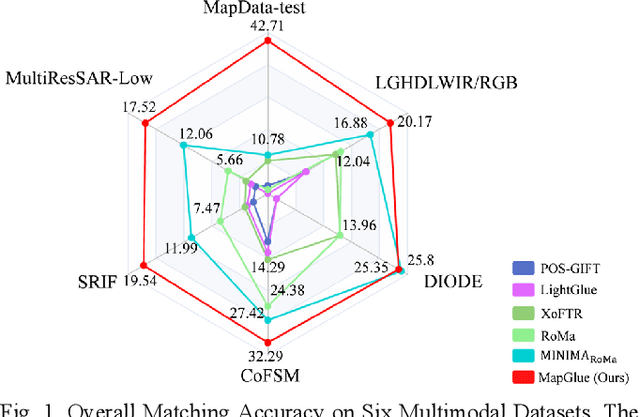
Multimodal remote sensing image (MRSI) matching is pivotal for cross-modal fusion, localization, and object detection, but it faces severe challenges due to geometric, radiometric, and viewpoint discrepancies across imaging modalities. Existing unimodal datasets lack scale and diversity, limiting deep learning solutions. This paper proposes MapGlue, a universal MRSI matching framework, and MapData, a large-scale multimodal dataset addressing these gaps. Our contributions are twofold. MapData, a globally diverse dataset spanning 233 sampling points, offers original images (7,000x5,000 to 20,000x15,000 pixels). After rigorous cleaning, it provides 121,781 aligned electronic map-visible image pairs (512x512 pixels) with hybrid manual-automated ground truth, addressing the scarcity of scalable multimodal benchmarks. MapGlue integrates semantic context with a dual graph-guided mechanism to extract cross-modal invariant features. This structure enables global-to-local interaction, enhancing descriptor robustness against modality-specific distortions. Extensive evaluations on MapData and five public datasets demonstrate MapGlue's superiority in matching accuracy under complex conditions, outperforming state-of-the-art methods. Notably, MapGlue generalizes effectively to unseen modalities without retraining, highlighting its adaptability. This work addresses longstanding challenges in MRSI matching by combining scalable dataset construction with a robust, semantics-driven framework. Furthermore, MapGlue shows strong generalization capabilities on other modality matching tasks for which it was not specifically trained. The dataset and code are available at https://github.com/PeihaoWu/MapGlue.
Multi-Resolution SAR and Optical Remote Sensing Image Registration Methods: A Review, Datasets, and Future Perspectives
Feb 03, 2025


Synthetic Aperture Radar (SAR) and optical image registration is essential for remote sensing data fusion, with applications in military reconnaissance, environmental monitoring, and disaster management. However, challenges arise from differences in imaging mechanisms, geometric distortions, and radiometric properties between SAR and optical images. As image resolution increases, fine SAR textures become more significant, leading to alignment issues and 3D spatial discrepancies. Two major gaps exist: the lack of a publicly available multi-resolution, multi-scene registration dataset and the absence of systematic analysis of current methods. To address this, the MultiResSAR dataset was created, containing over 10k pairs of multi-source, multi-resolution, and multi-scene SAR and optical images. Sixteen state-of-the-art algorithms were tested. Results show no algorithm achieves 100% success, and performance decreases as resolution increases, with most failing on sub-meter data. XoFTR performs best among deep learning methods (40.58%), while RIFT performs best among traditional methods (66.51%). Future research should focus on noise suppression, 3D geometric fusion, cross-view transformation modeling, and deep learning optimization for robust registration of high-resolution SAR and optical images. The dataset is available at https://github.com/betterlll/Multi-Resolution-SAR-dataset-.