Stefano Vincenzi
Spotting Virus from Satellites: Modeling the Circulation of West Nile Virus Through Graph Neural Networks
Sep 07, 2022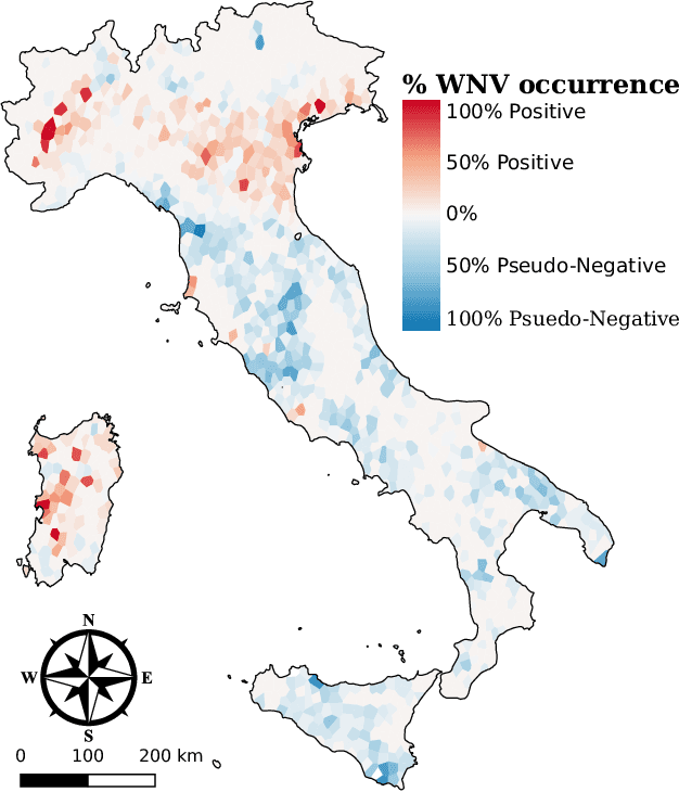
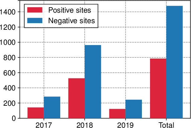

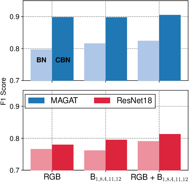
Abstract:The occurrence of West Nile Virus (WNV) represents one of the most common mosquito-borne zoonosis viral infections. Its circulation is usually associated with climatic and environmental conditions suitable for vector proliferation and virus replication. On top of that, several statistical models have been developed to shape and forecast WNV circulation: in particular, the recent massive availability of Earth Observation (EO) data, coupled with the continuous advances in the field of Artificial Intelligence, offer valuable opportunities. In this paper, we seek to predict WNV circulation by feeding Deep Neural Networks (DNNs) with satellite images, which have been extensively shown to hold environmental and climatic features. Notably, while previous approaches analyze each geographical site independently, we propose a spatial-aware approach that considers also the characteristics of close sites. Specifically, we build upon Graph Neural Networks (GNN) to aggregate features from neighbouring places, and further extend these modules to consider multiple relations, such as the difference in temperature and soil moisture between two sites, as well as the geographical distance. Moreover, we inject time-related information directly into the model to take into account the seasonality of virus spread. We design an experimental setting that combines satellite images - from Landsat and Sentinel missions - with ground truth observations of WNV circulation in Italy. We show that our proposed Multi-Adjacency Graph Attention Network (MAGAT) consistently leads to higher performance when paired with an appropriate pre-training stage. Finally, we assess the importance of each component of MAGAT in our ablation studies.
Generalising via Meta-Examples for Continual Learning in the Wild
Jan 28, 2021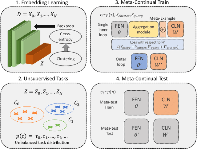
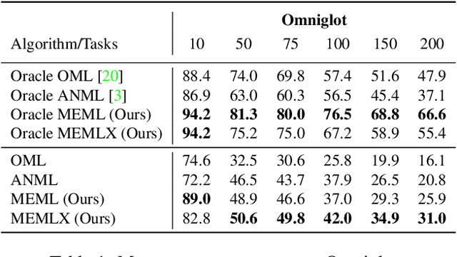
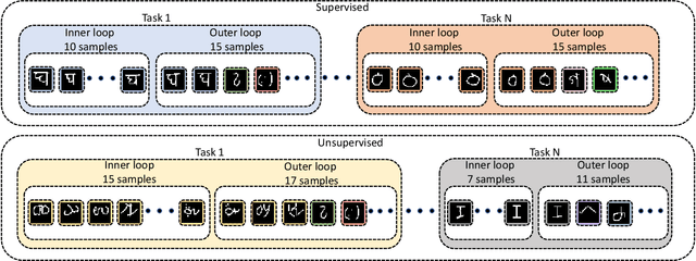
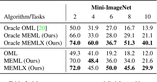
Abstract:Learning quickly and continually is still an ambitious task for neural networks. Indeed, many real-world applications do not reflect the learning setting where neural networks shine, as data are usually few, mostly unlabelled and come as a stream. To narrow this gap, we introduce FUSION - Few-shot UnSupervIsed cONtinual learning - a novel strategy which aims to deal with neural networks that "learn in the wild", simulating a real distribution and flow of unbalanced tasks. We equip FUSION with MEML - Meta-Example Meta-Learning - a new module that simultaneously alleviates catastrophic forgetting and favours the generalisation and future learning of new tasks. To encourage features reuse during the meta-optimisation, our model exploits a single inner loop per task, taking advantage of an aggregated representation achieved through the use of a self-attention mechanism. To further enhance the generalisation capability of MEML, we extend it by adopting a technique that creates various augmented tasks and optimises over the hardest. Experimental results on few-shot learning benchmarks show that our model exceeds the other baselines in both FUSION and fully supervised case. We also explore how it behaves in standard continual learning consistently outperforming state-of-the-art approaches.
Few-Shot Unsupervised Continual Learning through Meta-Examples
Sep 17, 2020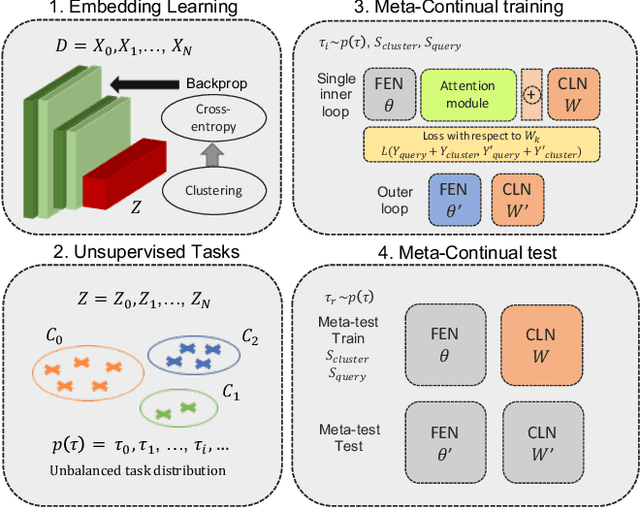
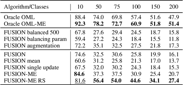
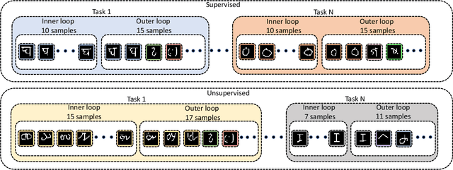
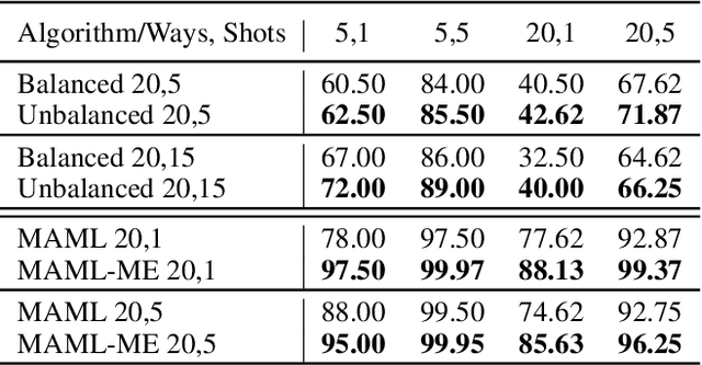
Abstract:In real-world applications, data do not reflect the ones commonly used for neural networks training, since they are usually few, unbalanced, unlabeled and can be available as a stream. Hence many existing deep learning solutions suffer from a limited range of applications, in particular in the case of online streaming data that evolve over time. To narrow this gap, in this work we introduce a novel and complex setting involving unsupervised meta-continual learning with unbalanced tasks. These tasks are built through a clustering procedure applied to a fitted embedding space. We exploit a meta-learning scheme that simultaneously alleviates catastrophic forgetting and favors the generalization to new tasks, even Out-of-Distribution ones. Moreover, to encourage feature reuse during the meta-optimization, we exploit a single inner loop taking advantage of an aggregated representation achieved through the use of a self-attention mechanism. Experimental results on few-shot learning benchmarks show competitive performance even compared to the supervised case. Additionally, we empirically observe that in an unsupervised scenario, the small tasks and the variability in the clusters pooling play a crucial role in the generalization capability of the network. Further, on complex datasets, the exploitation of more clusters than the true number of classes leads to higher results, even compared to the ones obtained with full supervision, suggesting that a predefined partitioning into classes can miss relevant structural information.
The color out of space: learning self-supervised representations for Earth Observation imagery
Jun 22, 2020
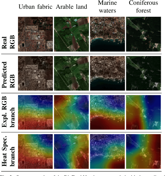


Abstract:The recent growth in the number of satellite images fosters the development of effective deep-learning techniques for Remote Sensing (RS). However, their full potential is untapped due to the lack of large annotated datasets. Such a problem is usually countered by fine-tuning a feature extractor that is previously trained on the ImageNet dataset. Unfortunately, the domain of natural images differs from the RS one, which hinders the final performance. In this work, we propose to learn meaningful representations from satellite imagery, leveraging its high-dimensionality spectral bands to reconstruct the visible colors. We conduct experiments on land cover classification (BigEarthNet) and West Nile Virus detection, showing that colorization is a solid pretext task for training a feature extractor. Furthermore, we qualitatively observe that guesses based on natural images and colorization rely on different parts of the input. This paves the way to an ensemble model that eventually outperforms both the above-mentioned techniques.
Spotting insects from satellites: modeling the presence of Culicoides imicola through Deep CNNs
Nov 22, 2019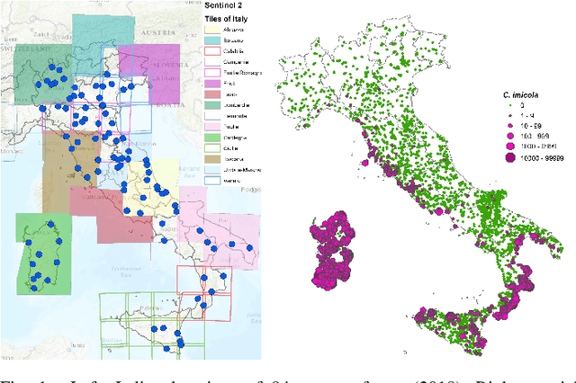
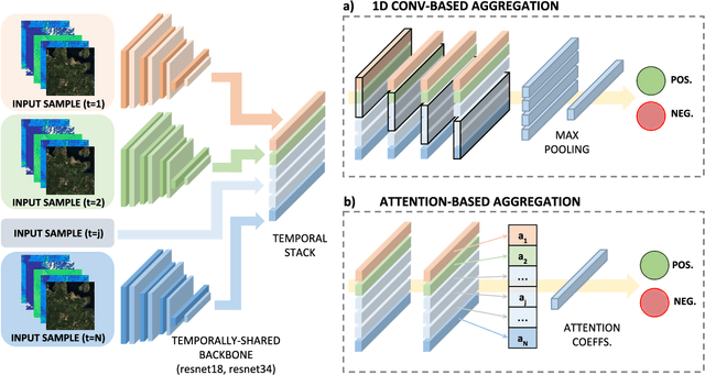
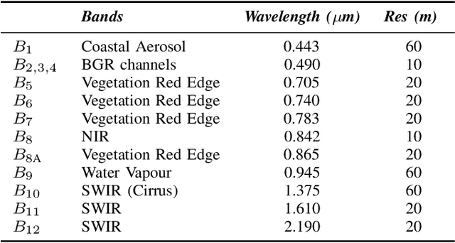

Abstract:Nowadays, Vector-Borne Diseases (VBDs) raise a severe threat for public health, accounting for a considerable amount of human illnesses. Recently, several surveillance plans have been put in place for limiting the spread of such diseases, typically involving on-field measurements. Such a systematic and effective plan still misses, due to the high costs and efforts required for implementing it. Ideally, any attempt in this field should consider the triangle vectors-host-pathogen, which is strictly linked to the environmental and climatic conditions. In this paper, we exploit satellite imagery from Sentinel-2 mission, as we believe they encode the environmental factors responsible for the vector's spread. Our analysis - conducted in a data-driver fashion - couples spectral images with ground-truth information on the abundance of Culicoides imicola. In this respect, we frame our task as a binary classification problem, underpinning Convolutional Neural Networks (CNNs) as being able to learn useful representation from multi-band images. Additionally, we provide a multi-instance variant, aimed at extracting temporal patterns from a short sequence of spectral images. Experiments show promising results, providing the foundations for novel supportive tools, which could depict where surveillance and prevention measures could be prioritized.
 Add to Chrome
 Add to Firefox
 Add to Edge