Simone Fobi Nsutezo
FLAVARS: A Multimodal Foundational Language and Vision Alignment Model for Remote Sensing
Jan 14, 2025


Abstract:Remote sensing imagery is dense with objects and contextual visual information. There is a recent trend to combine paired satellite images and text captions for pretraining performant encoders for downstream tasks. However, while contrastive image-text methods like CLIP enable vision-language alignment and zero-shot classification ability, vision-only downstream performance tends to degrade compared to image-only pretraining, such as MAE. In this paper, we propose FLAVARS, a pretraining method that combines the best of both contrastive learning and masked modeling, along with geospatial alignment via contrastive location encoding. We find that FLAVARS significantly outperforms a baseline of SkyCLIP for vision-only tasks such as KNN classification and semantic segmentation, +6\% mIOU on SpaceNet1, while retaining the ability to perform zero-shot classification, unlike MAE pretrained methods.
PGRID: Power Grid Reconstruction in Informal Developments Using High-Resolution Aerial Imagery
Dec 10, 2024


Abstract:As of 2023, a record 117 million people have been displaced worldwide, more than double the number from a decade ago [22]. Of these, 32 million are refugees under the UNHCR mandate, with 8.7 million residing in refugee camps. A critical issue faced by these populations is the lack of access to electricity, with 80% of the 8.7 million refugees and displaced persons in camps globally relying on traditional biomass for cooking and lacking reliable power for essential tasks such as cooking and charging phones. Often, the burden of collecting firewood falls on women and children, who frequently travel up to 20 kilometers into dangerous areas, increasing their vulnerability.[7] Electricity access could significantly alleviate these challenges, but a major obstacle is the lack of accurate power grid infrastructure maps, particularly in resource-constrained environments like refugee camps, needed for energy access planning. Existing power grid maps are often outdated, incomplete, or dependent on costly, complex technologies, limiting their practicality. To address this issue, PGRID is a novel application-based approach, which utilizes high-resolution aerial imagery to detect electrical poles and segment electrical lines, creating precise power grid maps. PGRID was tested in the Turkana region of Kenya, specifically the Kakuma and Kalobeyei Camps, covering 84 km2 and housing over 200,000 residents. Our findings show that PGRID delivers high-fidelity power grid maps especially in unplanned settlements, with F1-scores of 0.71 and 0.82 for pole detection and line segmentation, respectively. This study highlights a practical application for leveraging open data and limited labels to improve power grid mapping in unplanned settlements, where the growing number of displaced persons urgently need sustainable energy infrastructure solutions.
Mapping Global Floods with 10 Years of Satellite Radar Data
Nov 03, 2024Abstract:Floods cause extensive global damage annually, making effective monitoring essential. While satellite observations have proven invaluable for flood detection and tracking, comprehensive global flood datasets spanning extended time periods remain scarce. In this study, we introduce a novel deep learning flood detection model that leverages the cloud-penetrating capabilities of Sentinel-1 Synthetic Aperture Radar (SAR) satellite imagery, enabling consistent flood extent mapping in any weather condition. By applying this model to nearly 10 years of SAR data, we create a unique, longitudinal global flood extent dataset with predictions unaffected by cloud coverage, offering comprehensive and consistent insights into historically flood-prone areas over the past decade. We use our model predictions to identify historically flood-prone areas in Ethiopia and demonstrate real-time disaster response capabilities during the May 2024 floods in Kenya. Additionally, our longitudinal analysis reveals potential increasing trends in global flood extent over time, although further validation is required to explore links to climate change. To maximize impact, we provide public access to both our model predictions and a code repository, empowering researchers and practitioners worldwide to advance flood monitoring and enhance disaster response strategies.
Rapid building damage assessment workflow: An implementation for the 2023 Rolling Fork, Mississippi tornado event
Jun 21, 2023


Abstract:Rapid and accurate building damage assessments from high-resolution satellite imagery following a natural disaster is essential to inform and optimize first responder efforts. However, performing such building damage assessments in an automated manner is non-trivial due to the challenges posed by variations in disaster-specific damage, diversity in satellite imagery, and the dearth of extensive, labeled datasets. To circumvent these issues, this paper introduces a human-in-the-loop workflow for rapidly training building damage assessment models after a natural disaster. This article details a case study using this workflow, executed in partnership with the American Red Cross during a tornado event in Rolling Fork, Mississippi in March, 2023. The output from our human-in-the-loop modeling process achieved a precision of 0.86 and recall of 0.80 for damaged buildings when compared to ground truth data collected post-disaster. This workflow was implemented end-to-end in under 2 hours per satellite imagery scene, highlighting its potential for real-time deployment.
Mask Conditional Synthetic Satellite Imagery
Feb 08, 2023


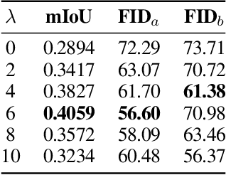
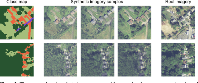
Abstract:In this paper we propose a mask-conditional synthetic image generation model for creating synthetic satellite imagery datasets. Given a dataset of real high-resolution images and accompanying land cover masks, we show that it is possible to train an upstream conditional synthetic imagery generator, use that generator to create synthetic imagery with the land cover masks, then train a downstream model on the synthetic imagery and land cover masks that achieves similar test performance to a model that was trained with the real imagery. Further, we find that incorporating a mixture of real and synthetic imagery acts as a data augmentation method, producing better models than using only real imagery (0.5834 vs. 0.5235 mIoU). Finally, we find that encouraging diversity of outputs in the upstream model is a necessary component for improved downstream task performance. We have released code for reproducing our work on GitHub, see https://github.com/ms-synthetic-satellite-image/synthetic-satellite-imagery .
 Add to Chrome
 Add to Firefox
 Add to Edge