Ruixun Liu
ZoomEarth: Active Perception for Ultra-High-Resolution Geospatial Vision-Language Tasks
Nov 15, 2025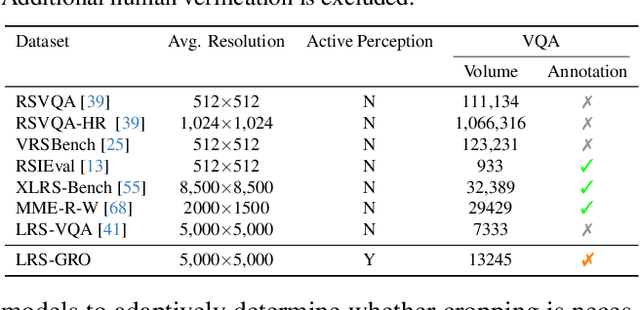
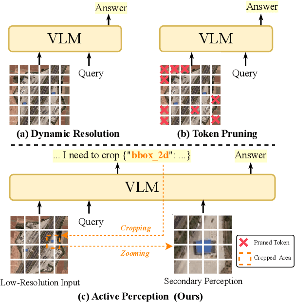
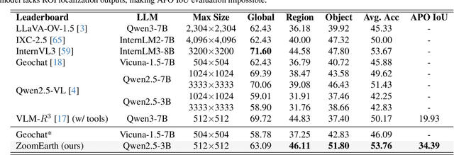
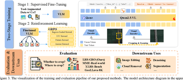
Abstract:Ultra-high-resolution (UHR) remote sensing (RS) images offer rich fine-grained information but also present challenges in effective processing. Existing dynamic resolution and token pruning methods are constrained by a passive perception paradigm, suffering from increased redundancy when obtaining finer visual inputs. In this work, we explore a new active perception paradigm that enables models to revisit information-rich regions. First, we present LRS-GRO, a large-scale benchmark dataset tailored for active perception in UHR RS processing, encompassing 17 question types across global, region, and object levels, annotated via a semi-automatic pipeline. Building on LRS-GRO, we propose ZoomEarth, an adaptive cropping-zooming framework with a novel Region-Guided reward that provides fine-grained guidance. Trained via supervised fine-tuning (SFT) and Group Relative Policy Optimization (GRPO), ZoomEarth achieves state-of-the-art performance on LRS-GRO and, in the zero-shot setting, on three public UHR remote sensing benchmarks. Furthermore, ZoomEarth can be seamlessly integrated with downstream models for tasks such as cloud removal, denoising, segmentation, and image editing through simple tool interfaces, demonstrating strong versatility and extensibility.
Annotation-Free Open-Vocabulary Segmentation for Remote-Sensing Images
Aug 25, 2025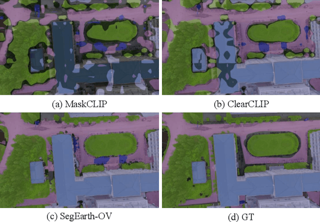
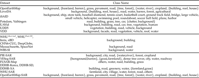
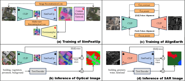

Abstract:Semantic segmentation of remote sensing (RS) images is pivotal for comprehensive Earth observation, but the demand for interpreting new object categories, coupled with the high expense of manual annotation, poses significant challenges. Although open-vocabulary semantic segmentation (OVSS) offers a promising solution, existing frameworks designed for natural images are insufficient for the unique complexities of RS data. They struggle with vast scale variations and fine-grained details, and their adaptation often relies on extensive, costly annotations. To address this critical gap, this paper introduces SegEarth-OV, the first framework for annotation-free open-vocabulary segmentation of RS images. Specifically, we propose SimFeatUp, a universal upsampler that robustly restores high-resolution spatial details from coarse features, correcting distorted target shapes without any task-specific post-training. We also present a simple yet effective Global Bias Alleviation operation to subtract the inherent global context from patch features, significantly enhancing local semantic fidelity. These components empower SegEarth-OV to effectively harness the rich semantics of pre-trained VLMs, making OVSS possible in optical RS contexts. Furthermore, to extend the framework's universality to other challenging RS modalities like SAR images, where large-scale VLMs are unavailable and expensive to create, we introduce AlignEarth, which is a distillation-based strategy and can efficiently transfer semantic knowledge from an optical VLM encoder to an SAR encoder, bypassing the need to build SAR foundation models from scratch and enabling universal OVSS across diverse sensor types. Extensive experiments on both optical and SAR datasets validate that SegEarth-OV can achieve dramatic improvements over the SOTA methods, establishing a robust foundation for annotation-free and open-world Earth observation.
Flow Diverse and Efficient: Learning Momentum Flow Matching via Stochastic Velocity Field Sampling
Jun 10, 2025Abstract:Recently, the rectified flow (RF) has emerged as the new state-of-the-art among flow-based diffusion models due to its high efficiency advantage in straight path sampling, especially with the amazing images generated by a series of RF models such as Flux 1.0 and SD 3.0. Although a straight-line connection between the noisy and natural data distributions is intuitive, fast, and easy to optimize, it still inevitably leads to: 1) Diversity concerns, which arise since straight-line paths only cover a fairly restricted sampling space. 2) Multi-scale noise modeling concerns, since the straight line flow only needs to optimize the constant velocity field $\bm v$ between the two distributions $\bm\pi_0$ and $\bm\pi_1$. In this work, we present Discretized-RF, a new family of rectified flow (also called momentum flow models since they refer to the previous velocity component and the random velocity component in each diffusion step), which discretizes the straight path into a series of variable velocity field sub-paths (namely ``momentum fields'') to expand the search space, especially when close to the distribution $p_\text{noise}$. Different from the previous case where noise is directly superimposed on $\bm x$, we introduce noise on the velocity $\bm v$ of the sub-path to change its direction in order to improve the diversity and multi-scale noise modeling abilities. Experimental results on several representative datasets demonstrate that learning momentum flow matching by sampling random velocity fields will produce trajectories that are both diverse and efficient, and can consistently generate high-quality and diverse results. Code is available at https://github.com/liuruixun/momentum-fm.
MV-CC: Mask Enhanced Video Model for Remote Sensing Change Caption
Oct 31, 2024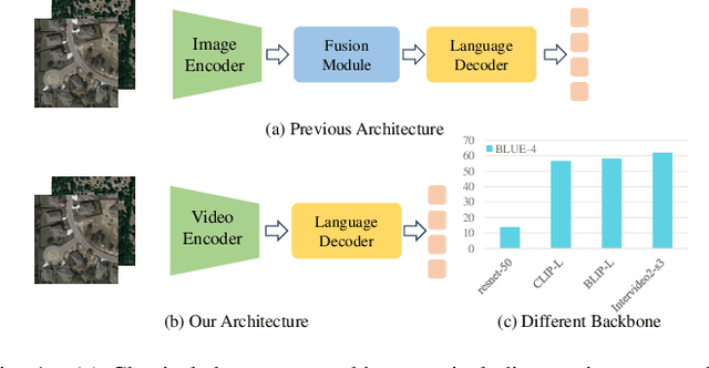
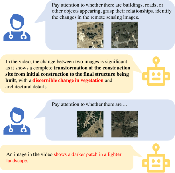
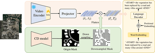

Abstract:Remote sensing image change caption (RSICC) aims to provide natural language descriptions for bi-temporal remote sensing images. Since Change Caption (CC) task requires both spatial and temporal features, previous works follow an encoder-fusion-decoder architecture. They use an image encoder to extract spatial features and the fusion module to integrate spatial features and extract temporal features, which leads to increasingly complex manual design of the fusion module. In this paper, we introduce a novel video model-based paradigm without design of the fusion module and propose a Mask-enhanced Video model for Change Caption (MV-CC). Specifically, we use the off-the-shelf video encoder to simultaneously extract the temporal and spatial features of bi-temporal images. Furthermore, the types of changes in the CC are set based on specific task requirements, and to enable the model to better focus on the regions of interest, we employ masks obtained from the Change Detection (CD) method to explicitly guide the CC model. Experimental results demonstrate that our proposed method can obtain better performance compared with other state-of-the-art RSICC methods. The code is available at https://github.com/liuruixun/MV-CC.
SegEarth-OV: Towards Traning-Free Open-Vocabulary Segmentation for Remote Sensing Images
Oct 02, 2024Abstract:Remote sensing image plays an irreplaceable role in fields such as agriculture, water resources, military, and disaster relief. Pixel-level interpretation is a critical aspect of remote sensing image applications; however, a prevalent limitation remains the need for extensive manual annotation. For this, we try to introduce open-vocabulary semantic segmentation (OVSS) into the remote sensing context. However, due to the sensitivity of remote sensing images to low-resolution features, distorted target shapes and ill-fitting boundaries are exhibited in the prediction mask. To tackle this issue, we propose a simple and general upsampler, SimFeatUp, to restore lost spatial information in deep features in a training-free style. Further, based on the observation of the abnormal response of local patch tokens to [CLS] token in CLIP, we propose to execute a straightforward subtraction operation to alleviate the global bias in patch tokens. Extensive experiments are conducted on 17 remote sensing datasets spanning semantic segmentation, building extraction, road detection, and flood detection tasks. Our method achieves an average of 5.8%, 8.2%, 4%, and 15.3% improvement over state-of-the-art methods on 4 tasks. All codes are released. \url{https://earth-insights.github.io/SegEarth-OV}
Rethinking the Graph Polynomial Filter via Positive and Negative Coupling Analysis
Apr 16, 2024


Abstract:Recently, the optimization of polynomial filters within Spectral Graph Neural Networks (GNNs) has emerged as a prominent research focus. Existing spectral GNNs mainly emphasize polynomial properties in filter design, introducing computational overhead and neglecting the integration of crucial graph structure information. We argue that incorporating graph information into basis construction can enhance understanding of polynomial basis, and further facilitate simplified polynomial filter design. Motivated by this, we first propose a Positive and Negative Coupling Analysis (PNCA) framework, where the concepts of positive and negative activation are defined and their respective and mixed effects are analysed. Then, we explore PNCA from the message propagation perspective, revealing the subtle information hidden in the activation process. Subsequently, PNCA is used to analyze the mainstream polynomial filters, and a novel simple basis that decouples the positive and negative activation and fully utilizes graph structure information is designed. Finally, a simple GNN (called GSCNet) is proposed based on the new basis. Experimental results on the benchmark datasets for node classification verify that our GSCNet obtains better or comparable results compared with existing state-of-the-art GNNs while demanding relatively less computational time.
Class Similarity Transition: Decoupling Class Similarities and Imbalance from Generalized Few-shot Segmentation
Apr 08, 2024


Abstract:In Generalized Few-shot Segmentation (GFSS), a model is trained with a large corpus of base class samples and then adapted on limited samples of novel classes. This paper focuses on the relevance between base and novel classes, and improves GFSS in two aspects: 1) mining the similarity between base and novel classes to promote the learning of novel classes, and 2) mitigating the class imbalance issue caused by the volume difference between the support set and the training set. Specifically, we first propose a similarity transition matrix to guide the learning of novel classes with base class knowledge. Then, we leverage the Label-Distribution-Aware Margin (LDAM) loss and Transductive Inference to the GFSS task to address the problem of class imbalance as well as overfitting the support set. In addition, by extending the probability transition matrix, the proposed method can mitigate the catastrophic forgetting of base classes when learning novel classes. With a simple training phase, our proposed method can be applied to any segmentation network trained on base classes. We validated our methods on the adapted version of OpenEarthMap. Compared to existing GFSS baselines, our method excels them all from 3% to 7% and ranks second in the OpenEarthMap Land Cover Mapping Few-Shot Challenge at the completion of this paper. Code: https://github.com/earth-insights/ClassTrans
 Add to Chrome
 Add to Firefox
 Add to Edge