R. Lily Hu
Recurrent Convolutional Deep Neural Networks for Modeling Time-Resolved Wildfire Spread Behavior
Oct 28, 2022Abstract:The increasing incidence and severity of wildfires underscores the necessity of accurately predicting their behavior. While high-fidelity models derived from first principles offer physical accuracy, they are too computationally expensive for use in real-time fire response. Low-fidelity models sacrifice some physical accuracy and generalizability via the integration of empirical measurements, but enable real-time simulations for operational use in fire response. Machine learning techniques offer the ability to bridge these objectives by learning first-principles physics while achieving computational speedup. While deep learning approaches have demonstrated the ability to predict wildfire propagation over large time periods, time-resolved fire-spread predictions are needed for active fire management. In this work, we evaluate the ability of deep learning approaches in accurately modeling the time-resolved dynamics of wildfires. We use an autoregressive process in which a convolutional recurrent deep learning model makes predictions that propagate a wildfire over 15 minute increments. We demonstrate the model in application to three simulated datasets of increasing complexity, containing both field fires with homogeneous fuel distribution as well as real-world topologies sampled from the California region of the United States. We show that even after 100 autoregressive predictions representing more than 24 hours of simulated fire spread, the resulting models generate stable and realistic propagation dynamics, achieving a Jaccard score between 0.89 and 0.94 when predicting the resulting fire scar.
Next Day Wildfire Spread: A Machine Learning Data Set to Predict Wildfire Spreading from Remote-Sensing Data
Dec 04, 2021
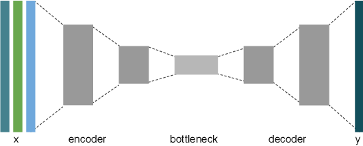
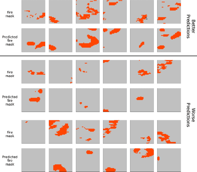
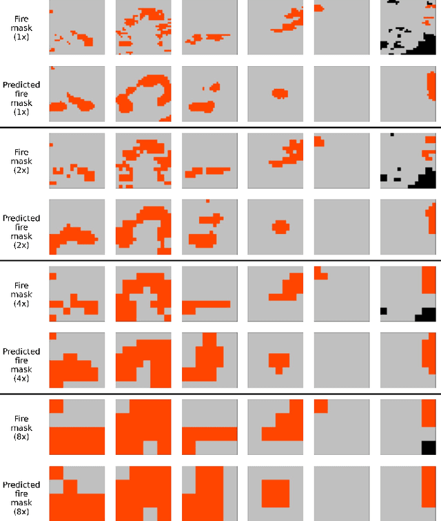
Abstract:Predicting wildfire spread is critical for land management and disaster preparedness. To this end, we present `Next Day Wildfire Spread,' a curated, large-scale, multivariate data set of historical wildfires aggregating nearly a decade of remote-sensing data across the United States. In contrast to existing fire data sets based on Earth observation satellites, our data set combines 2D fire data with multiple explanatory variables (e.g., topography, vegetation, weather, drought index, population density) aligned over 2D regions, providing a feature-rich data set for machine learning. To demonstrate the usefulness of this data set, we implement a convolutional autoencoder that takes advantage of the spatial information of this data to predict wildfire spread. We compare the performance of the neural network with other machine learning models: logistic regression and random forest. This data set can be used as a benchmark for developing wildfire propagation models based on remote sensing data for a lead time of one day.
Dynamic Placement of Rapidly Deployable Mobile Sensor Robots Using Machine Learning and Expected Value of Information
Nov 15, 2021


Abstract:Although the Industrial Internet of Things has increased the number of sensors permanently installed in industrial plants, there will be gaps in coverage due to broken sensors or sparse density in very large plants, such as in the petrochemical industry. Modern emergency response operations are beginning to use Small Unmanned Aerial Systems (sUAS) that have the ability to drop sensor robots to precise locations. sUAS can provide longer-term persistent monitoring that aerial drones are unable to provide. Despite the relatively low cost of these assets, the choice of which robotic sensing systems to deploy to which part of an industrial process in a complex plant environment during emergency response remains challenging. This paper describes a framework for optimizing the deployment of emergency sensors as a preliminary step towards realizing the responsiveness of robots in disaster circumstances. AI techniques (Long short-term memory, 1-dimensional convolutional neural network, logistic regression, and random forest) identify regions where sensors would be most valued without requiring humans to enter the potentially dangerous area. In the case study described, the cost function for optimization considers costs of false-positive and false-negative errors. Decisions on mitigation include implementing repairs or shutting down the plant. The Expected Value of Information (EVI) is used to identify the most valuable type and location of physical sensors to be deployed to increase the decision-analytic value of a sensor network. This method is applied to a case study using the Tennessee Eastman process data set of a chemical plant, and we discuss implications of our findings for operation, distribution, and decision-making of sensors in plant emergency and resilience scenarios.
Deep Learning Models for Predicting Wildfires from Historical Remote-Sensing Data
Oct 15, 2020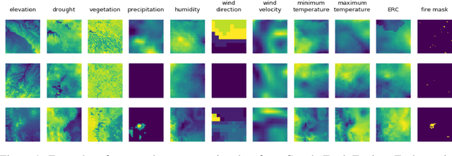


Abstract:Identifying regions that have high likelihood for wildfires is a key component of land and forestry management and disaster preparedness. We create a data set by aggregating nearly a decade of remote-sensing data and historical fire records to predict wildfires. This prediction problem is framed as three machine learning tasks. Results are compared and analyzed for four different deep learning models to estimate wildfire likelihood. The results demonstrate that deep learning models can successfully identify areas of high fire likelihood using aggregated data about vegetation, weather, and topography with an AUC of 83%.
Image Segmentation to Distinguish Between Overlapping Human Chromosomes
Dec 20, 2017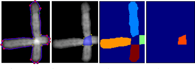
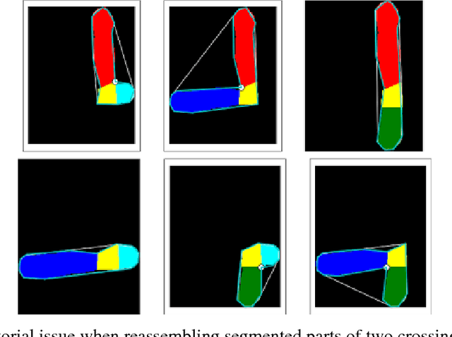
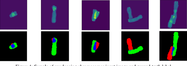
Abstract:In medicine, visualizing chromosomes is important for medical diagnostics, drug development, and biomedical research. Unfortunately, chromosomes often overlap and it is necessary to identify and distinguish between the overlapping chromosomes. A segmentation solution that is fast and automated will enable scaling of cost effective medicine and biomedical research. We apply neural network-based image segmentation to the problem of distinguishing between partially overlapping DNA chromosomes. A convolutional neural network is customized for this problem. The results achieved intersection over union (IOU) scores of 94.7% for the overlapping region and 88-94% on the non-overlapping chromosome regions.
 Add to Chrome
 Add to Firefox
 Add to Edge