Muer Tie
LMPOcc: 3D Semantic Occupancy Prediction Utilizing Long-Term Memory Prior from Historical Traversals
Apr 18, 2025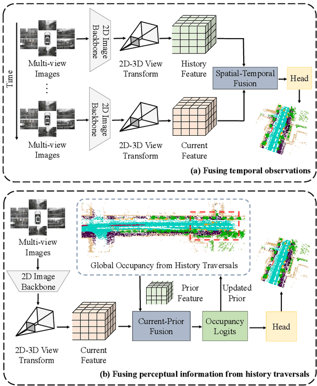
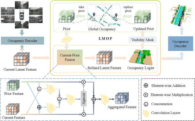
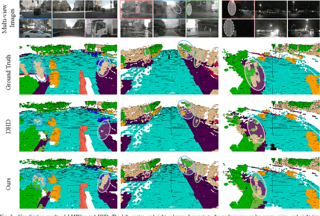

Abstract:Vision-based 3D semantic occupancy prediction is critical for autonomous driving, enabling unified modeling of static infrastructure and dynamic agents. In practice, autonomous vehicles may repeatedly traverse identical geographic locations under varying environmental conditions, such as weather fluctuations and illumination changes. Existing methods in 3D occupancy prediction predominantly integrate adjacent temporal contexts. However, these works neglect to leverage perceptual information, which is acquired from historical traversals of identical geographic locations. In this paper, we propose Longterm Memory Prior Occupancy (LMPOcc), the first 3D occupancy prediction methodology that exploits long-term memory priors derived from historical traversal perceptual outputs. We introduce a plug-and-play architecture that integrates long-term memory priors to enhance local perception while simultaneously constructing global occupancy representations. To adaptively aggregate prior features and current features, we develop an efficient lightweight Current-Prior Fusion module. Moreover, we propose a model-agnostic prior format to ensure compatibility across diverse occupancy prediction baselines. LMPOcc achieves state-of-the-art performance validated on the Occ3D-nuScenes benchmark, especially on static semantic categories. Additionally, experimental results demonstrate LMPOcc's ability to construct global occupancy through multi-vehicle crowdsourcing.
VINGS-Mono: Visual-Inertial Gaussian Splatting Monocular SLAM in Large Scenes
Jan 14, 2025


Abstract:VINGS-Mono is a monocular (inertial) Gaussian Splatting (GS) SLAM framework designed for large scenes. The framework comprises four main components: VIO Front End, 2D Gaussian Map, NVS Loop Closure, and Dynamic Eraser. In the VIO Front End, RGB frames are processed through dense bundle adjustment and uncertainty estimation to extract scene geometry and poses. Based on this output, the mapping module incrementally constructs and maintains a 2D Gaussian map. Key components of the 2D Gaussian Map include a Sample-based Rasterizer, Score Manager, and Pose Refinement, which collectively improve mapping speed and localization accuracy. This enables the SLAM system to handle large-scale urban environments with up to 50 million Gaussian ellipsoids. To ensure global consistency in large-scale scenes, we design a Loop Closure module, which innovatively leverages the Novel View Synthesis (NVS) capabilities of Gaussian Splatting for loop closure detection and correction of the Gaussian map. Additionally, we propose a Dynamic Eraser to address the inevitable presence of dynamic objects in real-world outdoor scenes. Extensive evaluations in indoor and outdoor environments demonstrate that our approach achieves localization performance on par with Visual-Inertial Odometry while surpassing recent GS/NeRF SLAM methods. It also significantly outperforms all existing methods in terms of mapping and rendering quality. Furthermore, we developed a mobile app and verified that our framework can generate high-quality Gaussian maps in real time using only a smartphone camera and a low-frequency IMU sensor. To the best of our knowledge, VINGS-Mono is the first monocular Gaussian SLAM method capable of operating in outdoor environments and supporting kilometer-scale large scenes.
O2V-Mapping: Online Open-Vocabulary Mapping with Neural Implicit Representation
Apr 10, 2024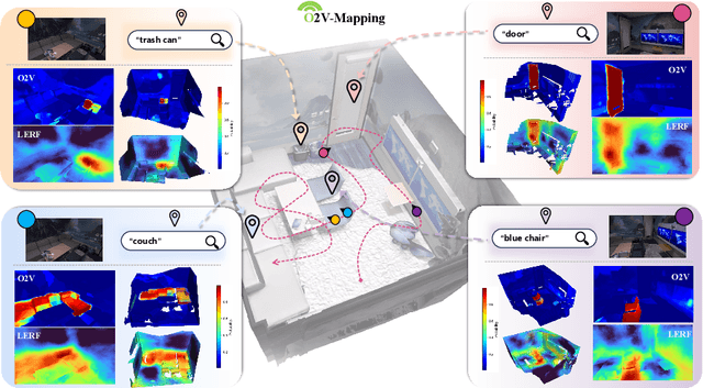
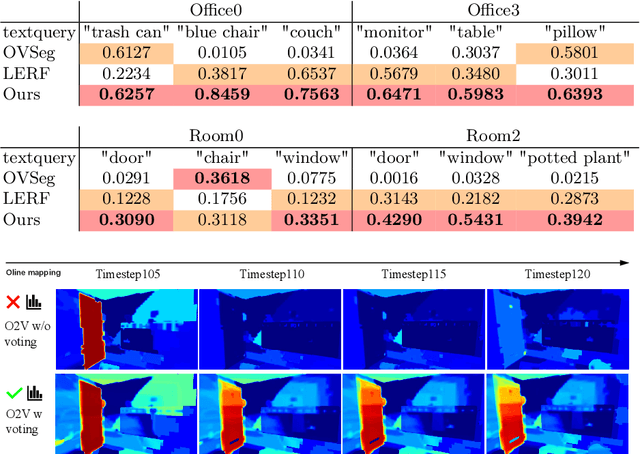
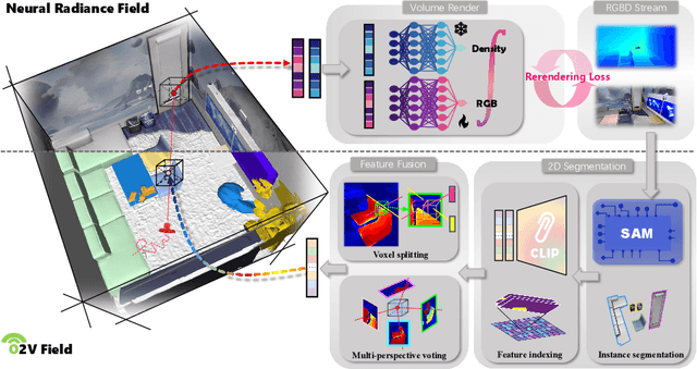
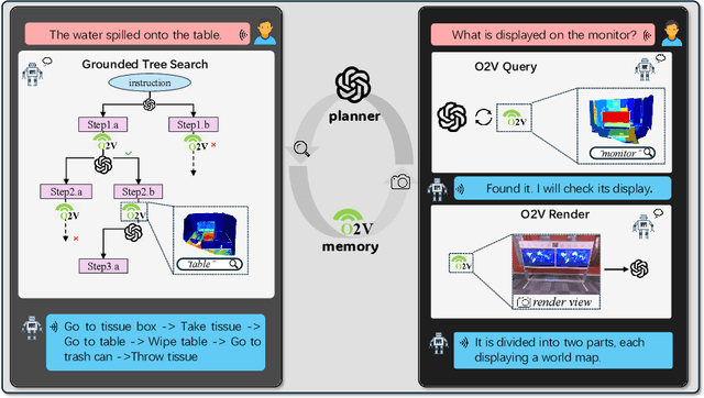
Abstract:Online construction of open-ended language scenes is crucial for robotic applications, where open-vocabulary interactive scene understanding is required. Recently, neural implicit representation has provided a promising direction for online interactive mapping. However, implementing open-vocabulary scene understanding capability into online neural implicit mapping still faces three challenges: lack of local scene updating ability, blurry spatial hierarchical semantic segmentation and difficulty in maintaining multi-view consistency. To this end, we proposed O2V-mapping, which utilizes voxel-based language and geometric features to create an open-vocabulary field, thus allowing for local updates during online training process. Additionally, we leverage a foundational model for image segmentation to extract language features on object-level entities, achieving clear segmentation boundaries and hierarchical semantic features. For the purpose of preserving consistency in 3D object properties across different viewpoints, we propose a spatial adaptive voxel adjustment mechanism and a multi-view weight selection method. Extensive experiments on open-vocabulary object localization and semantic segmentation demonstrate that O2V-mapping achieves online construction of language scenes while enhancing accuracy, outperforming the previous SOTA method.
HGS-Mapping: Online Dense Mapping Using Hybrid Gaussian Representation in Urban Scenes
Mar 29, 2024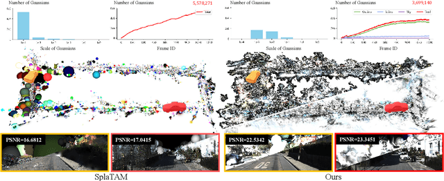

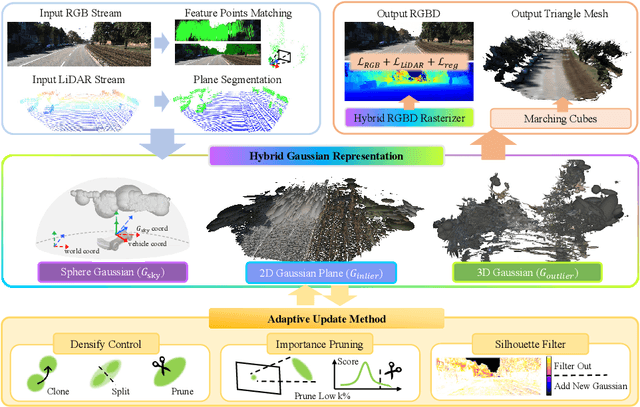

Abstract:Online dense mapping of urban scenes forms a fundamental cornerstone for scene understanding and navigation of autonomous vehicles. Recent advancements in mapping methods are mainly based on NeRF, whose rendering speed is too slow to meet online requirements. 3D Gaussian Splatting (3DGS), with its rendering speed hundreds of times faster than NeRF, holds greater potential in online dense mapping. However, integrating 3DGS into a street-view dense mapping framework still faces two challenges, including incomplete reconstruction due to the absence of geometric information beyond the LiDAR coverage area and extensive computation for reconstruction in large urban scenes. To this end, we propose HGS-Mapping, an online dense mapping framework in unbounded large-scale scenes. To attain complete construction, our framework introduces Hybrid Gaussian Representation, which models different parts of the entire scene using Gaussians with distinct properties. Furthermore, we employ a hybrid Gaussian initialization mechanism and an adaptive update method to achieve high-fidelity and rapid reconstruction. To the best of our knowledge, we are the first to integrate Gaussian representation into online dense mapping of urban scenes. Our approach achieves SOTA reconstruction accuracy while only employing 66% number of Gaussians, leading to 20% faster reconstruction speed.
 Add to Chrome
 Add to Firefox
 Add to Edge