Marwan Dhuheir
Multi-UAV Multi-RIS QoS-Aware Aerial Communication Systems using DRL and PSO
Jun 16, 2024


Abstract:Recently, Unmanned Aerial Vehicles (UAVs) have attracted the attention of researchers in academia and industry for providing wireless services to ground users in diverse scenarios like festivals, large sporting events, natural and man-made disasters due to their advantages in terms of versatility and maneuverability. However, the limited resources of UAVs (e.g., energy budget and different service requirements) can pose challenges for adopting UAVs for such applications. Our system model considers a UAV swarm that navigates an area, providing wireless communication to ground users with RIS support to improve the coverage of the UAVs. In this work, we introduce an optimization model with the aim of maximizing the throughput and UAVs coverage through optimal path planning of UAVs and multi-RIS phase configurations. The formulated optimization is challenging to solve using standard linear programming techniques, limiting its applicability in real-time decision-making. Therefore, we introduce a two-step solution using deep reinforcement learning and particle swarm optimization. We conduct extensive simulations and compare our approach to two competitive solutions presented in the recent literature. Our simulation results demonstrate that our adopted approach is 20 \% better than the brute-force approach and 30\% better than the baseline solution in terms of QoS.
Meta Reinforcement Learning for Strategic IoT Deployments Coverage in Disaster-Response UAV Swarms
Jan 20, 2024


Abstract:In the past decade, Unmanned Aerial Vehicles (UAVs) have grabbed the attention of researchers in academia and industry for their potential use in critical emergency applications, such as providing wireless services to ground users and collecting data from areas affected by disasters, due to their advantages in terms of maneuverability and movement flexibility. The UAVs' limited resources, energy budget, and strict mission completion time have posed challenges in adopting UAVs for these applications. Our system model considers a UAV swarm that navigates an area collecting data from ground IoT devices focusing on providing better service for strategic locations and allowing UAVs to join and leave the swarm (e.g., for recharging) in a dynamic way. In this work, we introduce an optimization model with the aim of minimizing the total energy consumption and provide the optimal path planning of UAVs under the constraints of minimum completion time and transmit power. The formulated optimization is NP-hard making it not applicable for real-time decision making. Therefore, we introduce a light-weight meta-reinforcement learning solution that can also cope with sudden changes in the environment through fast convergence. We conduct extensive simulations and compare our approach to three state-of-the-art learning models. Our simulation results prove that our introduced approach is better than the three state-of-the-art algorithms in providing coverage to strategic locations with fast convergence.
LLHR: Low Latency and High Reliability CNN Distributed Inference for Resource-Constrained UAV Swarms
May 25, 2023Abstract:Recently, Unmanned Aerial Vehicles (UAVs) have shown impressive performance in many critical applications, such as surveillance, search and rescue operations, environmental monitoring, etc. In many of these applications, the UAVs capture images as well as other sensory data and then send the data processing requests to remote servers. Nevertheless, this approach is not always practical in real-time-based applications due to unstable connections, limited bandwidth, limited energy, and strict end-to-end latency. One promising solution is to divide the inference requests into subtasks that can be distributed among UAVs in a swarm based on the available resources. Moreover, these tasks create intermediate results that need to be transmitted reliably as the swarm moves to cover the area. Our system model deals with real-time requests, aiming to find the optimal transmission power that guarantees higher reliability and low latency. We formulate the Low Latency and High-Reliability (LLHR) distributed inference as an optimization problem, and due to the complexity of the problem, we divide it into three subproblems. In the first subproblem, we find the optimal transmit power of the connected UAVs with guaranteed transmission reliability. The second subproblem aims to find the optimal positions of the UAVs in the grid, while the last subproblem finds the optimal placement of the CNN layers in the available UAVs. We conduct extensive simulations and compare our work to two baseline models demonstrating that our model outperforms the competing models.
* arXiv admin note: substantial text overlap with arXiv:2212.11201
Deep Reinforcement Learning for Trajectory Path Planning and Distributed Inference in Resource-Constrained UAV Swarms
Dec 21, 2022


Abstract:The deployment flexibility and maneuverability of Unmanned Aerial Vehicles (UAVs) increased their adoption in various applications, such as wildfire tracking, border monitoring, etc. In many critical applications, UAVs capture images and other sensory data and then send the captured data to remote servers for inference and data processing tasks. However, this approach is not always practical in real-time applications due to the connection instability, limited bandwidth, and end-to-end latency. One promising solution is to divide the inference requests into multiple parts (layers or segments), with each part being executed in a different UAV based on the available resources. Furthermore, some applications require the UAVs to traverse certain areas and capture incidents; thus, planning their paths becomes critical particularly, to reduce the latency of making the collaborative inference process. Specifically, planning the UAVs trajectory can reduce the data transmission latency by communicating with devices in the same proximity while mitigating the transmission interference. This work aims to design a model for distributed collaborative inference requests and path planning in a UAV swarm while respecting the resource constraints due to the computational load and memory usage of the inference requests. The model is formulated as an optimization problem and aims to minimize latency. The formulated problem is NP-hard so finding the optimal solution is quite complex; thus, this paper introduces a real-time and dynamic solution for online applications using deep reinforcement learning. We conduct extensive simulations and compare our results to the-state-of-the-art studies demonstrating that our model outperforms the competing models.
Emotion Recognition for Healthcare Surveillance Systems Using Neural Networks: A Survey
Jul 13, 2021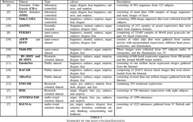

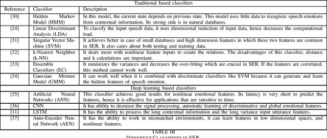

Abstract:Recognizing the patient's emotions using deep learning techniques has attracted significant attention recently due to technological advancements. Automatically identifying the emotions can help build smart healthcare centers that can detect depression and stress among the patients in order to start the medication early. Using advanced technology to identify emotions is one of the most exciting topics as it defines the relationships between humans and machines. Machines learned how to predict emotions by adopting various methods. In this survey, we present recent research in the field of using neural networks to recognize emotions. We focus on studying emotions' recognition from speech, facial expressions, and audio-visual input and show the different techniques of deploying these algorithms in the real world. These three emotion recognition techniques can be used as a surveillance system in healthcare centers to monitor patients. We conclude the survey with a presentation of the challenges and the related future work to provide an insight into the applications of using emotion recognition.
Efficient Real-Time Image Recognition Using Collaborative Swarm of UAVs and Convolutional Networks
Jul 09, 2021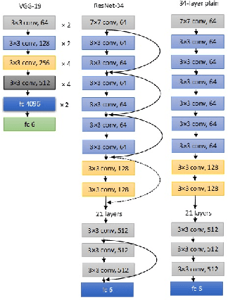
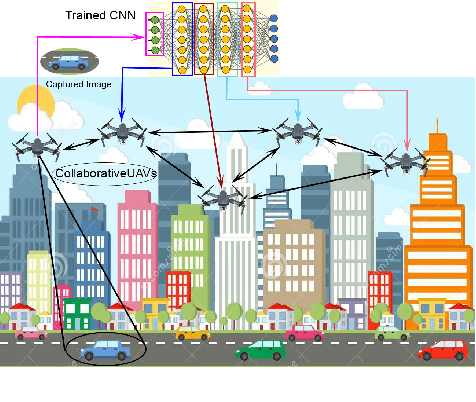
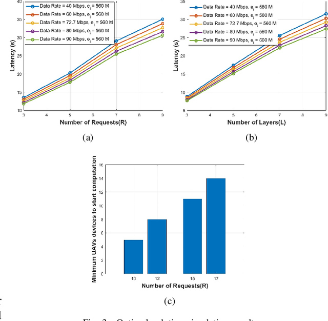
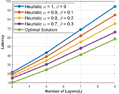
Abstract:Unmanned Aerial Vehicles (UAVs) have recently attracted significant attention due to their outstanding ability to be used in different sectors and serve in difficult and dangerous areas. Moreover, the advancements in computer vision and artificial intelligence have increased the use of UAVs in various applications and solutions, such as forest fires detection and borders monitoring. However, using deep neural networks (DNNs) with UAVs introduces several challenges of processing deeper networks and complex models, which restricts their on-board computation. In this work, we present a strategy aiming at distributing inference requests to a swarm of resource-constrained UAVs that classifies captured images on-board and finds the minimum decision-making latency. We formulate the model as an optimization problem that minimizes the latency between acquiring images and making the final decisions. The formulated optimization solution is an NP-hard problem. Hence it is not adequate for online resource allocation. Therefore, we introduce an online heuristic solution, namely DistInference, to find the layers placement strategy that gives the best latency among the available UAVs. The proposed approach is general enough to be used for different low decision-latency applications as well as for all CNN types organized into the pipeline of layers (e.g., VGG) or based on residual blocks (e.g., ResNet).
 Add to Chrome
 Add to Firefox
 Add to Edge