Manh Duong Phung
Event-based Reconfiguration Control for Time-varying Formation of Robot Swarms in Narrow Spaces
May 22, 2025Abstract:This study proposes an event-based reconfiguration control to navigate a robot swarm through challenging environments with narrow passages such as valleys, tunnels, and corridors. The robot swarm is modeled as an undirected graph, where each node represents a robot capable of collecting real-time data on the environment and the states of other robots in the formation. This data serves as the input for the controller to provide dynamic adjustments between the desired and straight-line configurations. The controller incorporates a set of behaviors, designed using artificial potential fields, to meet the requirements of goal-oriented motion, formation maintenance, tailgating, and collision avoidance. The stability of the formation control is guaranteed via the Lyapunov theorem. Simulation and comparison results show that the proposed controller not only successfully navigates the robot swarm through narrow spaces but also outperforms other established methods in key metrics including the success rate, heading order, speed, travel time, and energy efficiency. Software-in-the-loop tests have also been conducted to validate the controller's applicability in practical scenarios. The source code of the controller is available at https://github.com/duynamrcv/erc.
Multi-goal Rapidly Exploring Random Tree with Safety and Dynamic Constraints for UAV Cooperative Path Planning
Apr 16, 2025Abstract:Cooperative path planning is gaining its importance due to the increasing demand on using multiple unmanned aerial vehicles (UAVs) for complex missions. This work addresses the problem by introducing a new algorithm named MultiRRT that extends the rapidly exploring random tree (RRT) to generate paths for a group of UAVs to reach multiple goal locations at the same time. We first derive the dynamics constraint of the UAV and include it in the problem formulation. MultiRRT is then developed, taking into account the cooperative requirements and safe constraints during its path-searching process. The algorithm features two new mechanisms, node reduction and Bezier interpolation, to ensure the feasibility and optimality of the paths generated. Importantly, the interpolated paths are proven to meet the safety and dynamics constraints imposed by obstacles and the UAVs. A number of simulations, comparisons, and experiments have been conducted to evaluate the performance of the proposed approach. The results show that MultiRRT can generate collision-free paths for multiple UAVs to reach their goals with better scores in path length and smoothness metrics than state-of-the-art RRT variants including Theta-RRT, FN-RRT, RRT*, and RRT*-Smart. The generated paths are also tested in practical flights with real UAVs to evaluate their validity for cooperative tasks. The source code of the algorithm is available at https://github.com/duynamrcv/multi-target_RRT
Adaptive Twisting Sliding Control for Integrated Attack UAV's Autopilot and Guidance
Jan 17, 2025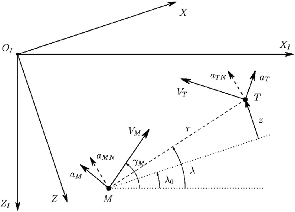

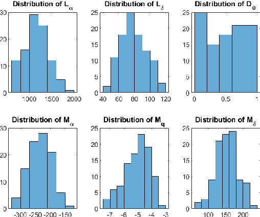
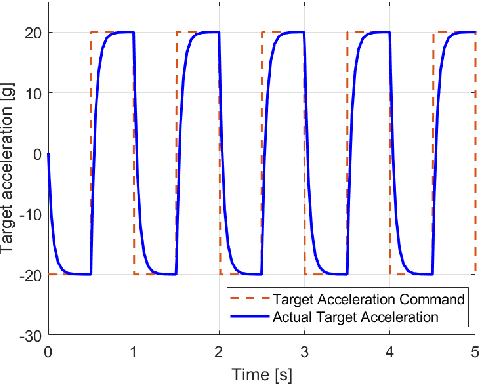
Abstract:This paper investigates an adaptive sliding-mode control for an integrated UAV autopilot and guidance system. First, a two-dimensional mathematical model of the system is derived by considering the incorporated lateral dynamics and relative kinematics of the UAV and its potential target of attack. Then, a sliding surface is derived utilizing the zero-effort miss distance. An adaptive twisting sliding mode (ATSMC) algorithm is applied to the integrated system. Simulation and comparisons have been accomplished. The results show our proposed design performs well in interception precision, even with high nonlinearity, uncertainties, disturbances, and abrupt changes in the target's movement, thanks to the adaptation strategy.
Path Planning for a UAV Swarm Using Formation Teaching-Learning-Based Optimization
Jan 16, 2025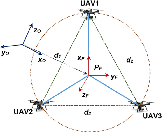

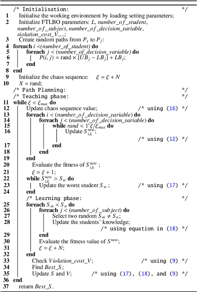
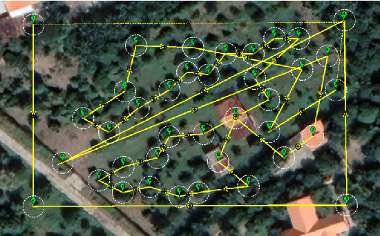
Abstract:This work addresses the path planning problem for a group of unmanned aerial vehicles (UAVs) to maintain a desired formation during operation. Our approach formulates the problem as an optimization task by defining a set of fitness functions that not only ensure the formation but also include constraints for optimal and safe UAV operation. To optimize the fitness function and obtain a suboptimal path, we employ the teaching-learning-based optimization algorithm and then further enhance it with mechanisms such as mutation, elite strategy, and multi-subject combination. A number of simulations and experiments have been conducted to evaluate the proposed method. The results demonstrate that the algorithm successfully generates valid paths for the UAVs to fly in a triangular formation for an inspection task.
Navigation Variable-based Multi-objective Particle Swarm Optimization for UAV Path Planning with Kinematic Constraints
Jan 03, 2025Abstract:Path planning is essential for unmanned aerial vehicles (UAVs) as it determines the path that the UAV needs to follow to complete a task. This work addresses this problem by introducing a new algorithm called navigation variable-based multi-objective particle swarm optimization (NMOPSO). It first models path planning as an optimization problem via the definition of a set of objective functions that include optimality and safety requirements for UAV operation. The NMOPSO is then used to minimize those functions through Pareto optimal solutions. The algorithm features a new path representation based on navigation variables to include kinematic constraints and exploit the maneuverable characteristics of the UAV. It also includes an adaptive mutation mechanism to enhance the diversity of the swarm for better solutions. Comparisons with various algorithms have been carried out to benchmark the proposed approach. The results indicate that the NMOPSO performs better than not only other particle swarm optimization variants but also other state-of-the-art multi-objective and metaheuristic optimization algorithms. Experiments have also been conducted with real UAVs to confirm the validity of the approach for practical flights. The source code of the algorithm is available at https://github.com/ngandng/NMOPSO.
Socially Aware Motion Planning for Service Robots Using LiDAR and RGB-D Camera
Oct 13, 2024Abstract:Service robots that work alongside humans in a shared environment need a navigation system that takes into account not only physical safety but also social norms for mutual cooperation. In this paper, we introduce a motion planning system that includes human states such as positions and velocities and their personal space for social-aware navigation. The system first extracts human positions from the LiDAR and the RGB-D camera. It then uses the Kalman filter to fuse that information for human state estimation. An asymmetric Gaussian function is then employed to model human personal space based on their states. This model is used as the input to the dynamic window approach algorithm to generate trajectories for the robot. Experiments show that the robot is able to navigate alongside humans in a dynamic environment while respecting their physical and psychological comfort.
Model Predictive Control for Optimal Motion Planning of Unmanned Aerial Vehicles
Oct 13, 2024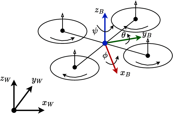

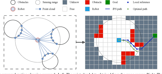
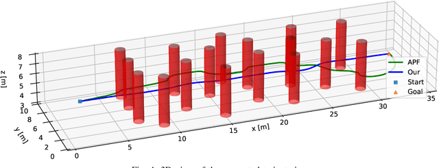
Abstract:Motion planning is an essential process for the navigation of unmanned aerial vehicles (UAVs) where they need to adapt to obstacles and different structures of their operating environment to reach the goal. This paper presents an optimal motion planner for UAVs operating in unknown complex environments. The motion planner receives point cloud data from a local range sensor and then converts it into a voxel grid representing the surrounding environment. A local trajectory guiding the UAV to the goal is then generated based on the voxel grid. This trajectory is further optimized using model predictive control (MPC) to enhance the safety, speed, and smoothness of UAV operation. The optimization is carried out via the definition of several cost functions and constraints, taking into account the UAV's dynamics and requirements. A number of simulations and comparisons with a state-of-the-art method have been conducted in a complex environment with many obstacles to evaluate the performance of our method. The results show that our method provides not only shorter and smoother trajectories but also faster and more stable speed profiles. It is also energy efficient making it suitable for various UAV applications.
Radial Basis Function Neural Networks for Formation Control of Unmanned Aerial Vehicles
Apr 21, 2024Abstract:This paper addresses the problem of controlling multiple unmanned aerial vehicles (UAVs) cooperating in a formation to carry out a complex task such as surface inspection. We first use the virtual leader-follower model to determine the topology and trajectory of the formation. A double-loop control system combining backstepping and sliding mode control techniques is then designed for the UAVs to track the trajectory. A radial basis function neural network (RBFNN) capable of estimating external disturbances is developed to enhance the robustness of the controller. The stability of the controller is proven by using the Lyapunov theorem. A number of comparisons and software-in-the-loop (SIL) tests have been conducted to evaluate the performance of the proposed controller. The results show that our controller not only outperforms other state-of-the-art controllers but is also sufficient for complex tasks of UAVs such as collecting surface data for inspection. The source code of our controller can be found at https://github.com/duynamrcv/rbf_bsmc
Object Detection in Thermal Images Using Deep Learning for Unmanned Aerial Vehicles
Feb 13, 2024Abstract:This work presents a neural network model capable of recognizing small and tiny objects in thermal images collected by unmanned aerial vehicles. Our model consists of three parts, the backbone, the neck, and the prediction head. The backbone is developed based on the structure of YOLOv5 combined with the use of a transformer encoder at the end. The neck includes a BI-FPN block combined with the use of a sliding window and a transformer to increase the information fed into the prediction head. The prediction head carries out the detection by evaluating feature maps with the Sigmoid function. The use of transformers with attention and sliding windows increases recognition accuracy while keeping the model at a reasonable number of parameters and computation requirements for embedded systems. Experiments conducted on public dataset VEDAI and our collected datasets show that our model has a higher accuracy than state-of-the-art methods such as ResNet, Faster RCNN, ComNet, ViT, YOLOv5, SMPNet, and DPNetV3. Experiments on the embedded computer Jetson AGX show that our model achieves a real-time computation speed with a stability rate of over 90%.
Self-Reconfigurable V-shape Formation of Multiple UAVs in Narrow Space Environments
Feb 13, 2024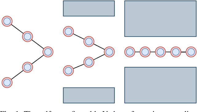
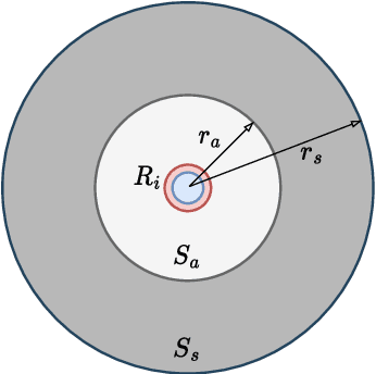
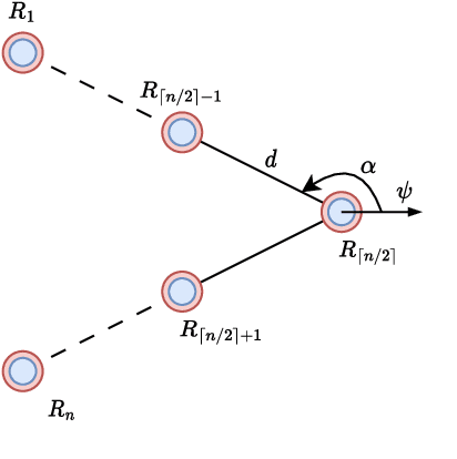
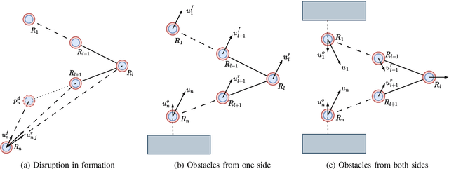
Abstract:This paper presents the design and implementation of a self-reconfigurable V-shape formation controller for multiple unmanned aerial vehicles (UAVs) navigating through narrow spaces in a dense obstacle environment. The selection of the V-shape formation is motivated by its maneuverability and visibility advantages. The main objective is to develop an effective formation control strategy that allows UAVs to autonomously adjust their positions to form the desired formation while navigating through obstacles. To achieve this, we propose a distributed behavior-based control algorithm that combines the behaviors designed for individual UAVs so that they together navigate the UAVs to their desired positions. The reconfiguration process is automatic, utilizing individual UAV sensing within the formation, allowing for dynamic adaptations such as opening/closing wings or merging into a straight line. Simulation results show that the self-reconfigurable V-shape formation offers adaptability and effectiveness for UAV formations in complex operational scenarios.
 Add to Chrome
 Add to Firefox
 Add to Edge