Loïc Denis
EPFL
Just Project! Multi-Channel Despeckling, the Easy Way
Aug 21, 2024
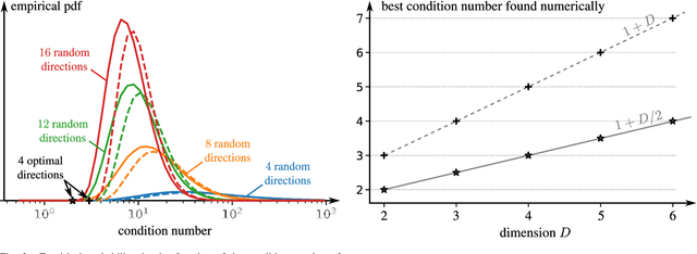
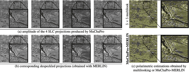
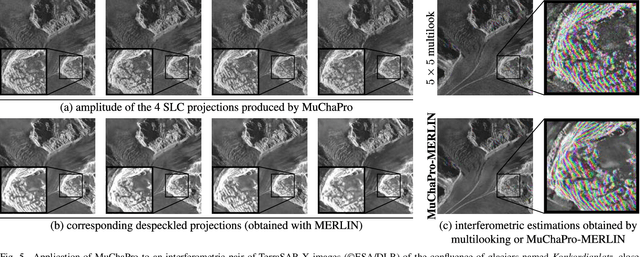
Abstract:Reducing speckle fluctuations in multi-channel SAR images is essential in many applications of SAR imaging such as polarimetric classification or interferometric height estimation. While single-channel despeckling has widely benefited from the application of deep learning techniques, extensions to multi-channel SAR images are much more challenging.This paper introduces MuChaPro, a generic framework that exploits existing single-channel despeckling methods. The key idea is to generate numerous single-channel projections, restore these projections, and recombine them into the final multi-channel estimate. This simple approach is shown to be effective in polarimetric and/or interferometric modalities. A special appeal of MuChaPro is the possibility to apply a self-supervised training strategy to learn sensor-specific networks for single-channel despeckling.
Multitemporal SAR images change detection and visualization using RABASAR and simplified GLR
Jul 15, 2023Abstract:Understanding the state of changed areas requires that precise information be given about the changes. Thus, detecting different kinds of changes is important for land surface monitoring. SAR sensors are ideal to fulfil this task, because of their all-time and all-weather capabilities, with good accuracy of the acquisition geometry and without effects of atmospheric constituents for amplitude data. In this study, we propose a simplified generalized likelihood ratio ($S_{GLR}$) method assuming that corresponding temporal pixels have the same equivalent number of looks (ENL). Thanks to the denoised data provided by a ratio-based multitemporal SAR image denoising method (RABASAR), we successfully applied this similarity test approach to compute the change areas. A new change magnitude index method and an improved spectral clustering-based change classification method are also developed. In addition, we apply the simplified generalized likelihood ratio to detect the maximum change magnitude time, and the change starting and ending times. Then, we propose to use an adaptation of the REACTIV method to visualize the detection results vividly. The effectiveness of the proposed methods is demonstrated through the processing of simulated and SAR images, and the comparison with classical techniques. In particular, numerical experiments proved that the developed method has good performances in detecting farmland area changes, building area changes, harbour area changes and flooding area changes.
A Deep Learning Approach for SAR Tomographic Imaging of Forested Areas
Jan 20, 2023


Abstract:Synthetic aperture radar tomographic imaging reconstructs the three-dimensional reflectivity of a scene from a set of coherent acquisitions performed in an interferometric configuration. In forest areas, a large number of elements backscatter the radar signal within each resolution cell. To reconstruct the vertical reflectivity profile, state-of-the-art techniques perform a regularized inversion implemented in the form of iterative minimization algorithms. We show that light-weight neural networks can be trained to perform the tomographic inversion with a single feed-forward pass, leading to fast reconstructions that could better scale to the amount of data provided by the future BIOMASS mission. We train our encoder-decoder network using simulated data and validate our technique on real L-band and P-band data.
Multi-temporal speckle reduction with self-supervised deep neural networks
Jul 25, 2022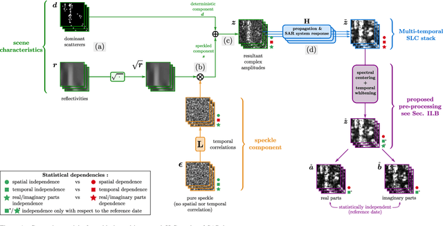
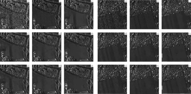
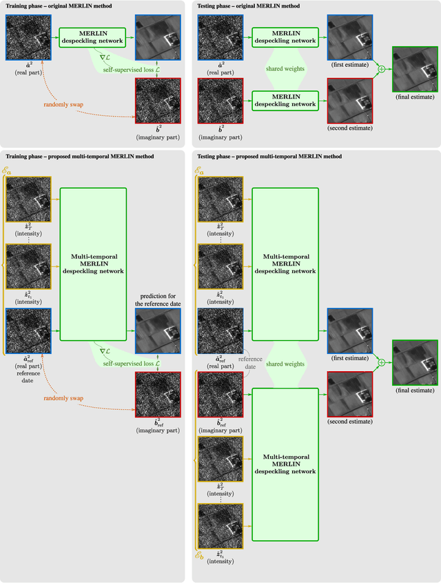
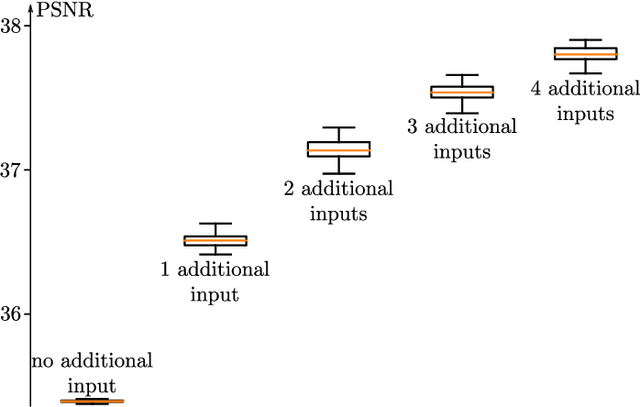
Abstract:Speckle filtering is generally a prerequisite to the analysis of synthetic aperture radar (SAR) images. Tremendous progress has been achieved in the domain of single-image despeckling. Latest techniques rely on deep neural networks to restore the various structures and textures peculiar to SAR images. The availability of time series of SAR images offers the possibility of improving speckle filtering by combining different speckle realizations over the same area. The supervised training of deep neural networks requires ground-truth speckle-free images. Such images can only be obtained indirectly through some form of averaging, by spatial or temporal integration, and are imperfect. Given the potential of very high quality restoration reachable by multi-temporal speckle filtering, the limitations of ground-truth images need to be circumvented. We extend a recent self-supervised training strategy for single-look complex SAR images, called MERLIN, to the case of multi-temporal filtering. This requires modeling the sources of statistical dependencies in the spatial and temporal dimensions as well as between the real and imaginary components of the complex amplitudes. Quantitative analysis on datasets with simulated speckle indicates a clear improvement of speckle reduction when additional SAR images are included. Our method is then applied to stacks of TerraSAR-X images and shown to outperform competing multi-temporal speckle filtering approaches. The code of the trained models is made freely available on the Gitlab of the IMAGES team of the LTCI Lab, T\'el\'ecom Paris Institut Polytechnique de Paris (https://gitlab.telecom-paris.fr/ring/multi-temporal-merlin/).
Fast strategies for multi-temporal speckle reduction of Sentinel-1 GRD images
Jul 22, 2022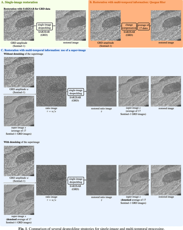
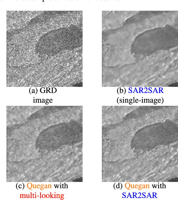
Abstract:Reducing speckle and limiting the variations of the physical parameters in Synthetic Aperture Radar (SAR) images is often a key-step to fully exploit the potential of such data. Nowadays, deep learning approaches produce state of the art results in single-image SAR restoration. Nevertheless, huge multi-temporal stacks are now often available and could be efficiently exploited to further improve image quality. This paper explores two fast strategies employing a single-image despeckling algorithm, namely SAR2SAR, in a multi-temporal framework. The first one is based on Quegan filter and replaces the local reflectivity pre-estimation by SAR2SAR. The second one uses SAR2SAR to suppress speckle from a ratio image encoding the multi-temporal information under the form of a "super-image", i.e. the temporal arithmetic mean of a time series. Experimental results on Sentinel-1 GRD data show that these two multi-temporal strategies provide improved filtering results while adding a limited computational cost.
As if by magic: self-supervised training of deep despeckling networks with MERLIN
Nov 15, 2021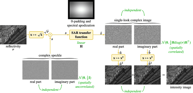
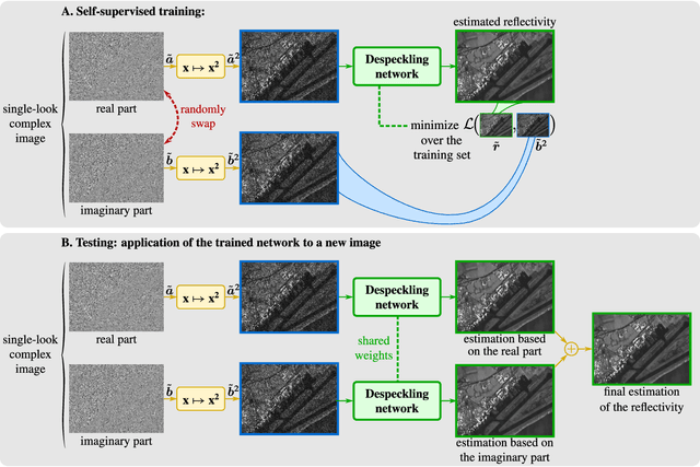
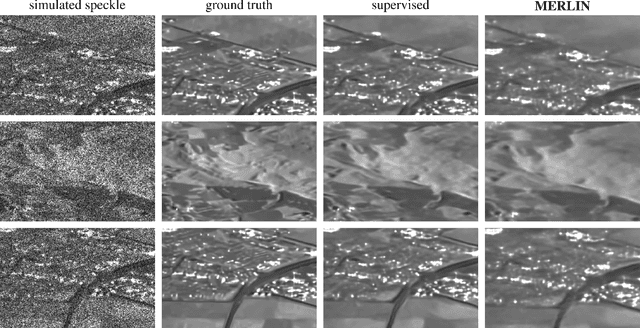
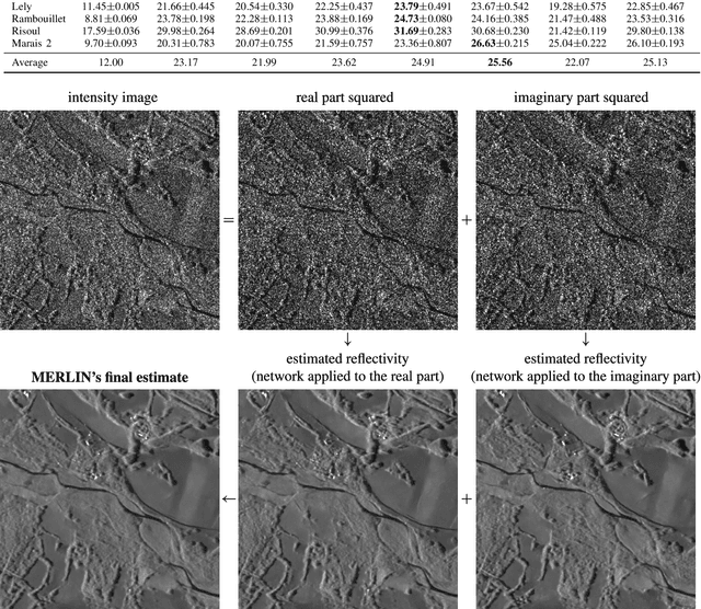
Abstract:Speckle fluctuations seriously limit the interpretability of synthetic aperture radar (SAR) images. Speckle reduction has thus been the subject of numerous works spanning at least four decades. Techniques based on deep neural networks have recently achieved a new level of performance in terms of SAR image restoration quality. Beyond the design of suitable network architectures or the selection of adequate loss functions, the construction of training sets is of uttermost importance. So far, most approaches have considered a supervised training strategy: the networks are trained to produce outputs as close as possible to speckle-free reference images. Speckle-free images are generally not available, which requires resorting to natural or optical images or the selection of stable areas in long time series to circumvent the lack of ground truth. Self-supervision, on the other hand, avoids the use of speckle-free images. We introduce a self-supervised strategy based on the separation of the real and imaginary parts of single-look complex SAR images, called MERLIN (coMplex sElf-supeRvised despeckLINg), and show that it offers a straightforward way to train all kinds of deep despeckling networks. Networks trained with MERLIN take into account the spatial correlations due to the SAR transfer function specific to a given sensor and imaging mode. By requiring only a single image, and possibly exploiting large archives, MERLIN opens the door to hassle-free as well as large-scale training of despeckling networks. The code of the trained models is made freely available at https://gitlab.telecom-paris.fr/RING/MERLIN.
Image Restoration for Remote Sensing: Overview and Toolbox
Jul 01, 2021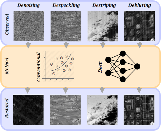
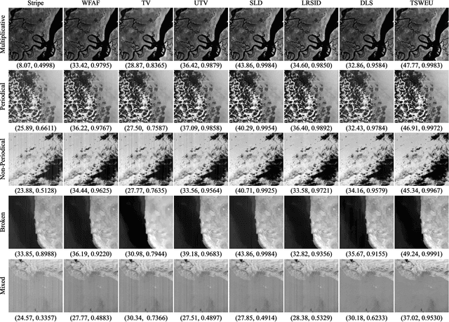
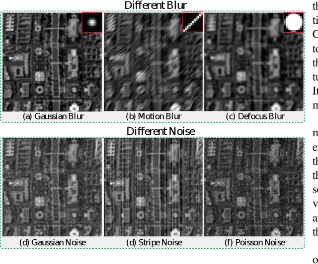

Abstract:Remote sensing provides valuable information about objects or areas from a distance in either active (e.g., RADAR and LiDAR) or passive (e.g., multispectral and hyperspectral) modes. The quality of data acquired by remotely sensed imaging sensors (both active and passive) is often degraded by a variety of noise types and artifacts. Image restoration, which is a vibrant field of research in the remote sensing community, is the task of recovering the true unknown image from the degraded observed image. Each imaging sensor induces unique noise types and artifacts into the observed image. This fact has led to the expansion of restoration techniques in different paths according to each sensor type. This review paper brings together the advances of image restoration techniques with particular focuses on synthetic aperture radar and hyperspectral images as the most active sub-fields of image restoration in the remote sensing community. We, therefore, provide a comprehensive, discipline-specific starting point for researchers at different levels (i.e., students, researchers, and senior researchers) willing to investigate the vibrant topic of data restoration by supplying sufficient detail and references. Additionally, this review paper accompanies a toolbox to provide a platform to encourage interested students and researchers in the field to further explore the restoration techniques and fast-forward the community. The toolboxes are provided in https://github.com/ImageRestorationToolbox.
Urban Surface Reconstruction in SAR Tomography by Graph-Cuts
Mar 12, 2021
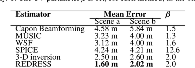
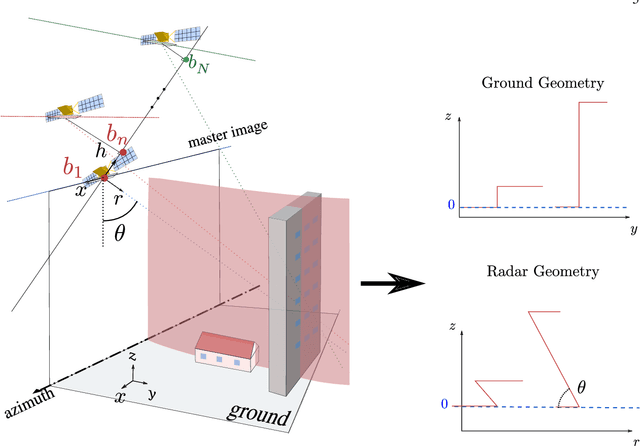
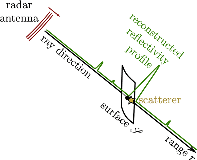
Abstract:SAR (Synthetic Aperture Radar) tomography reconstructs 3-D volumes from stacks of SAR images. High-resolution satellites such as TerraSAR-X provide images that can be combined to produce 3-D models. In urban areas, sparsity priors are generally enforced during the tomographic inversion process in order to retrieve the location of scatterers seen within a given radar resolution cell. However, such priors often miss parts of the urban surfaces. Those missing parts are typically regions of flat areas such as ground or rooftops. This paper introduces a surface segmentation algorithm based on the computation of the optimal cut in a flow network. This segmentation process can be included within the 3-D reconstruction framework in order to improve the recovery of urban surfaces. Illustrations on a TerraSAR-X tomographic dataset demonstrate the potential of the approach to produce a 3-D model of urban surfaces such as ground, fa\c{c}ades and rooftops.
Despeckling Sentinel-1 GRD images by deep learning and application to narrow river segmentation
Feb 01, 2021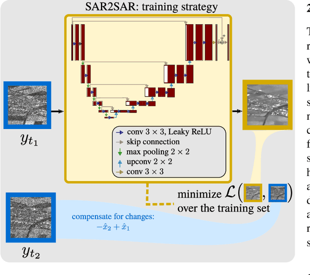

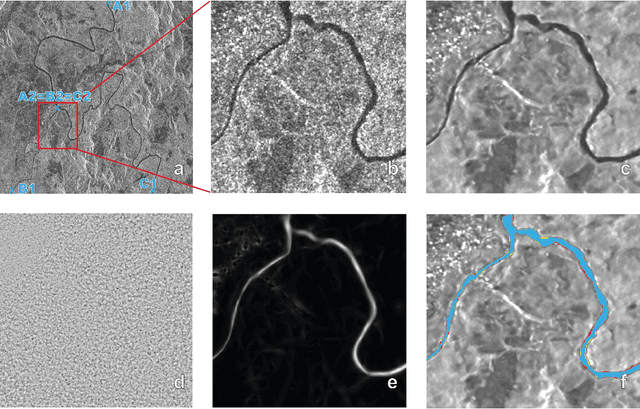
Abstract:This paper presents a despeckling method for Sentinel-1 GRD images based on the recently proposed framework "SAR2SAR": a self-supervised training strategy. Training the deep neural network on collections of Sentinel 1 GRD images leads to a despeckling algorithm that is robust to space-variant spatial correlations of speckle. Despeckled images improve the detection of structures like narrow rivers. We apply a detector based on exogenous information and a linear features detector and show that rivers are better segmented when the processing chain is applied to images pre-processed by our despeckling neural network.
Exploiting multi-temporal information for improved speckle reduction of Sentinel-1 SAR images by deep learning
Feb 01, 2021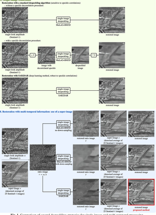
Abstract:Deep learning approaches show unprecedented results for speckle reduction in SAR amplitude images. The wide availability of multi-temporal stacks of SAR images can improve even further the quality of denoising. In this paper, we propose a flexible yet efficient way to integrate temporal information into a deep neural network for speckle suppression. Archives provide access to long time-series of SAR images, from which multi-temporal averages can be computed with virtually no remaining speckle fluctuations. The proposed method combines this multi-temporal average and the image at a given date in the form of a ratio image and uses a state-of-the-art neural network to remove the speckle in this ratio image. This simple strategy is shown to offer a noticeable improvement compared to filtering the original image without knowledge of the multi-temporal average.
 Add to Chrome
 Add to Firefox
 Add to Edge