 Add to Chrome
 Add to Firefox
 Add to Edge
Geo-Semantic-Parsing: AI-powered geoparsing by traversing semantic knowledge graphs
Mar 03, 2025Online social networks convey rich information about geospatial facets of reality. However in most cases, geographic information is not explicit and structured, thus preventing its exploitation in real-time applications. We address this limitation by introducing a novel geoparsing and geotagging technique called Geo-Semantic-Parsing (GSP). GSP identifies location references in free text and extracts the corresponding geographic coordinates. To reach this goal, we employ a semantic annotator to identify relevant portions of the input text and to link them to the corresponding entity in a knowledge graph. Then, we devise and experiment with several efficient strategies for traversing the knowledge graph, thus expanding the available set of information for the geoparsing task. Finally, we exploit all available information for learning a regression model that selects the best entity with which to geotag the input text. We evaluate GSP on a well-known reference dataset including almost 10k event-related tweets, achieving $F1=0.66$. We extensively compare our results with those of 2 baselines and 3 state-of-the-art geoparsing techniques, achieving the best performance. On the same dataset, competitors obtain $F1 \leq 0.55$. We conclude by providing in-depth analyses of our results, showing that the overall superior performance of GSP is mainly due to a large improvement in recall, with respect to existing techniques.
* Postprint of the article published in the Decision Support Systems journal. Please, cite accordingly
Temporal Dynamics of Coordinated Online Behavior: Stability, Archetypes, and Influence
Jan 17, 2023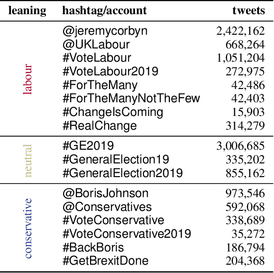
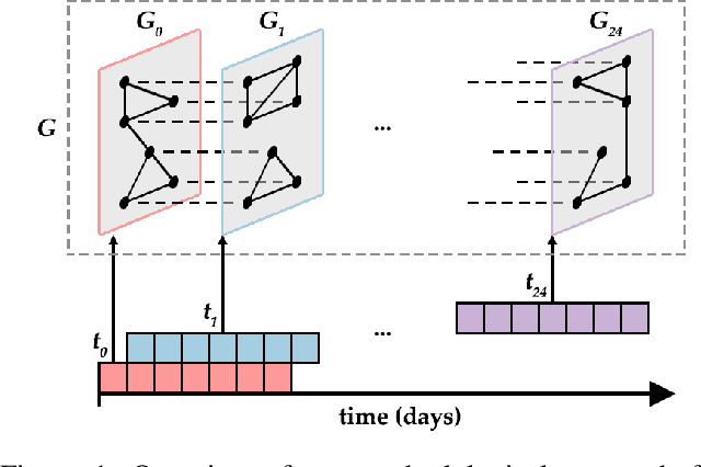
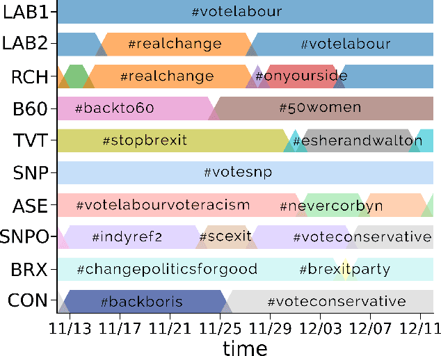

Large-scale online campaigns, malicious or otherwise, require a significant degree of coordination among participants, which sparked interest in the study of coordinated online behavior. State-of-the-art methods for detecting coordinated behavior perform static analyses, disregarding the temporal dynamics of coordination. Here, we carry out the first dynamic analysis of coordinated behavior. To reach our goal we build a multiplex temporal network and we perform dynamic community detection to identify groups of users that exhibited coordinated behaviors in time. Thanks to our novel approach we find that: (i) coordinated communities feature variable degrees of temporal instability; (ii) dynamic analyses are needed to account for such instability, and results of static analyses can be unreliable and scarcely representative of unstable communities; (iii) some users exhibit distinct archetypal behaviors that have important practical implications; (iv) content and network characteristics contribute to explaining why users leave and join coordinated communities. Our results demonstrate the advantages of dynamic analyses and open up new directions of research on the unfolding of online debates, on the strategies of coordinated communities, and on the patterns of online influence.
Towards better social crisis data with HERMES: Hybrid sensing for EmeRgency ManagEment System
Dec 04, 2019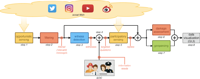
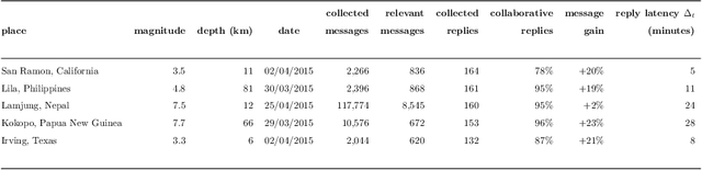
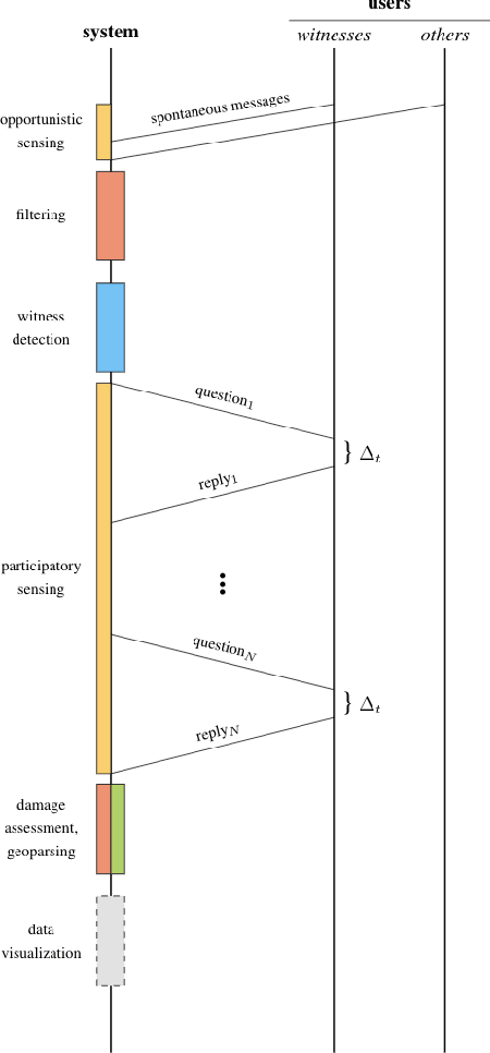

People involved in mass emergencies increasingly publish information-rich contents in online social networks (OSNs), thus acting as a distributed and resilient network of human sensors. In this work, we present HERMES, a system designed to enrich the information spontaneously disclosed by OSN users in the aftermath of disasters. HERMES leverages a mixed data collection strategy, called hybrid crowdsensing, and state-of-the-art AI techniques. Evaluated in real-world emergencies, HERMES proved to increase: (i) the amount of the available damage information; (ii) the density (up to 7x) and the variety (up to 18x) of the retrieved geographic information; (iii) the geographic coverage (up to 30%) and granularity.