L. Garrote
PointNetPGAP-SLC: A 3D LiDAR-based Place Recognition Approach with Segment-level Consistency Training for Mobile Robots in Horticulture
May 29, 2024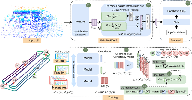

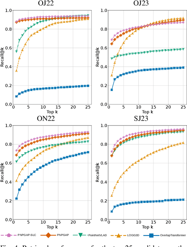

Abstract:This paper addresses robotic place recognition in horticultural environments using 3D-LiDAR technology and deep learning. Three main contributions are proposed: (i) a novel model called PointNetPGAP, which combines a global average pooling aggregator and a pairwise feature interaction aggregator; (ii) a Segment-Level Consistency (SLC) model, used only during training, with the goal of augmenting the contrastive loss with a context-specific training signal to enhance descriptors; and (iii) a novel dataset named HORTO-3DLM featuring sequences from orchards and strawberry plantations. The experimental evaluation, conducted on the new HORTO-3DLM dataset, compares PointNetPGAP at the sequence- and segment-level with state-of-the-art (SOTA) models, including OverlapTransformer, PointNetVLAD, and LOGG3D. Additionally, all models were trained and evaluated using the SLC. Empirical results obtained through a cross-validation evaluation protocol demonstrate the superiority of PointNetPGAP compared to existing SOTA models. PointNetPGAP emerges as the best model in retrieving the top-1 candidate, outperforming PointNetVLAD (the second-best model). Moreover, when comparing the impact of training with the SLC model, performance increased on four out of the five evaluated models, indicating that adding a context-specific signal to the contrastive loss leads to improved descriptors.
ORCHNet: A Robust Global Feature Aggregation approach for 3D LiDAR-based Place recognition in Orchards
Mar 01, 2023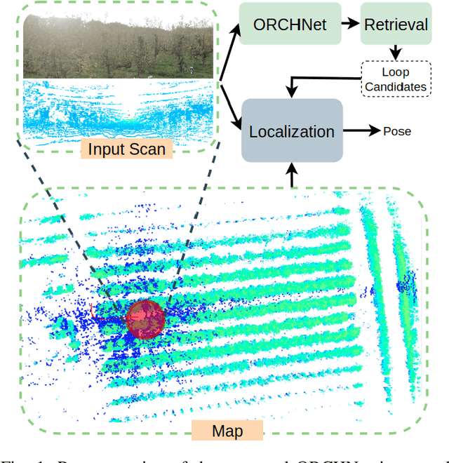


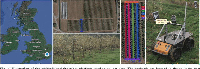
Abstract:Robust and reliable place recognition and loop closure detection in agricultural environments is still an open problem. In particular, orchards are a difficult case study due to structural similarity across the entire field. In this work, we address the place recognition problem in orchards resorting to 3D LiDAR data, which is considered a key modality for robustness. Hence, we propose ORCHNet, a deep-learning-based approach that maps 3D-LiDAR scans to global descriptors. Specifically, this work proposes a new global feature aggregation approach, which fuses multiple aggregation methods into a robust global descriptor. ORCHNet is evaluated on real-world data collected in orchards, comprising data from the summer and autumn seasons. To assess the robustness, We compare ORCHNet with state-of-the-art aggregation approaches on data from the same season and across seasons. Moreover, we additionally evaluate the proposed approach as part of a localization framework, where ORCHNet is used as a loop closure detector. The empirical results indicate that, on the place recognition task, ORCHNet outperforms the remaining approaches, and is also more robust across seasons. As for the localization, the edge cases where the path goes through the trees are solved when integrating ORCHNet as a loop detector, showing the potential applicability of the proposed approach in this task. The code and dataset will be publicly available at:\url{https://github.com/Cybonic/ORCHNet.git}
High-resolution LIDAR-based Depth Mapping using Bilateral Filter
Jun 17, 2016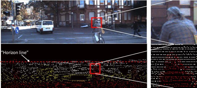

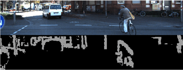

Abstract:High resolution depth-maps, obtained by upsampling sparse range data from a 3D-LIDAR, find applications in many fields ranging from sensory perception to semantic segmentation and object detection. Upsampling is often based on combining data from a monocular camera to compensate the low-resolution of a LIDAR. This paper, on the other hand, introduces a novel framework to obtain dense depth-map solely from a single LIDAR point cloud; which is a research direction that has been barely explored. The formulation behind the proposed depth-mapping process relies on local spatial interpolation, using sliding-window (mask) technique, and on the Bilateral Filter (BF) where the variable of interest, the distance from the sensor, is considered in the interpolation problem. In particular, the BF is conveniently modified to perform depth-map upsampling such that the edges (foreground-background discontinuities) are better preserved by means of a proposed method which influences the range-based weighting term. Other methods for spatial upsampling are discussed, evaluated and compared in terms of different error measures. This paper also researches the role of the mask's size in the performance of the implemented methods. Quantitative and qualitative results from experiments on the KITTI Database, using LIDAR point clouds only, show very satisfactory performance of the approach introduced in this work.
 Add to Chrome
 Add to Firefox
 Add to Edge