 Add to Chrome
 Add to Firefox
 Add to Edge
Reciprocity-Aware Convolutional Neural Networks for Map-Based Path Loss Prediction
Apr 04, 2025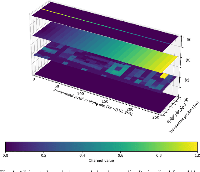
Path loss modeling is a widely used technique for estimating point-to-point losses along a communications link from transmitter (Tx) to receiver (Rx). Accurate path loss predictions can optimize use of the radio frequency spectrum and minimize unwanted interference. Modern path loss modeling often leverages data-driven approaches, using machine learning to train models on drive test measurement datasets. Drive tests primarily represent downlink scenarios, where the Tx is located on a building and the Rx is located on a moving vehicle. Consequently, trained models are frequently reserved for downlink coverage estimation, lacking representation of uplink scenarios. In this paper, we demonstrate that data augmentation can be used to train a path loss model that is generalized to uplink, downlink, and backhaul scenarios, training using only downlink drive test measurements. By adding a small number of synthetic samples representing uplink scenarios to the training set, root mean squared error is reduced by >8 dB on uplink examples in the test set.
Estimating Rural Path Loss with ITU-R P.1812-7 : Impact of Geospatial Inputs
Jan 20, 2025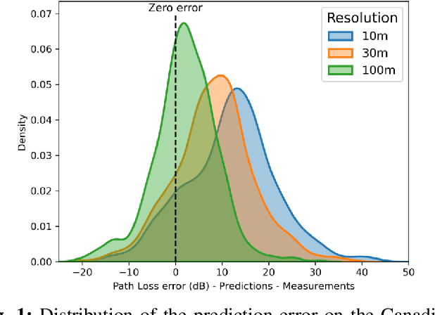


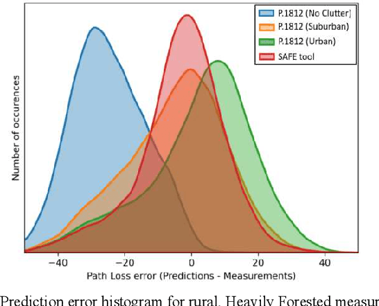
Accurate radio wave propagation modeling is essential for effective spectrum management by regulators and network deployment by operators. This paper investigates the ITU-R P.1812-7 (P.1812) propagation model's reliance on geospatial inputs, particularly clutter information, to improve path loss estimation, with an emphasis on rural geographic regions. The research evaluates the impact of geospatial elevation and land cover datasets, including Global Forest Canopy Height (GFCH), European Space Agency WorldCover, and Natural Resources Canada LandCover, on P.1812 propagation model prediction accuracy. Results highlight the trade-offs between dataset resolution, geospatial data availability, and representative clutter height assignments. Simulations reveal that high-resolution data do not always yield better results and that global datasets such as the GFCH provide a robust alternative when high-resolution data are unavailable or out-of-date. This study provides a set of guidelines for geospatial dataset integration to enhance P.1812's rural path loss predictions.
Path Loss Prediction Using Machine Learning with Extended Features
Jan 14, 2025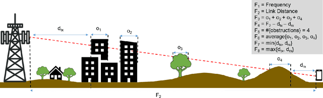
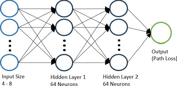
Wireless communications rely on path loss modeling, which is most effective when it includes the physical details of the propagation environment. Acquiring this data has historically been challenging, but geographic information system data is becoming increasingly available with higher resolution and accuracy. Access to such details enables propagation models to more accurately predict coverage and minimize interference in wireless deployments. Machine learning-based modeling can significantly support this effort, with feature-based approaches allowing for accurate, efficient, and scalable propagation modeling. Building on previous work, we introduce an extended set of features that improves prediction accuracy while, most importantly, maintaining model generalization across a broad range of environments.
Investigating Map-Based Path Loss Models: A Study of Feature Representations in Convolutional Neural Networks
Jan 13, 2025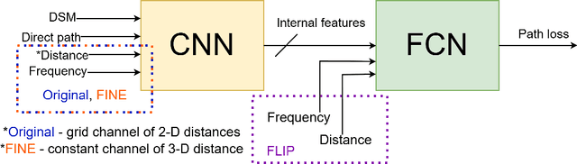
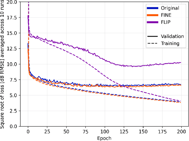
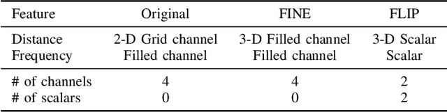
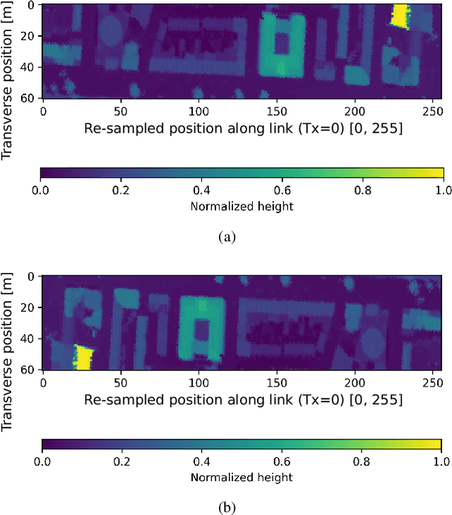
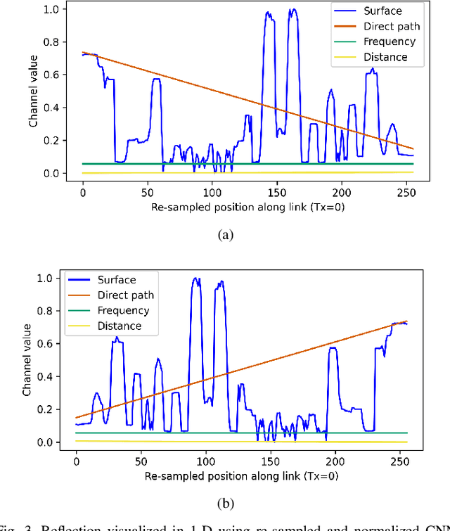
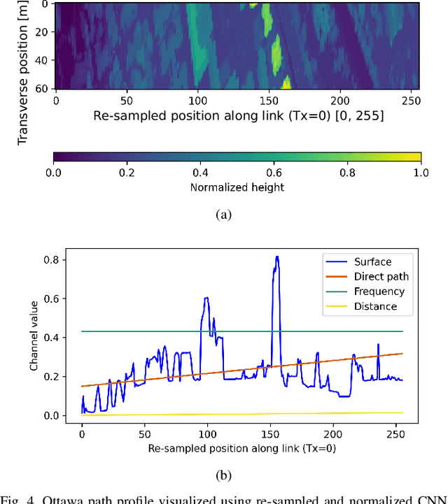
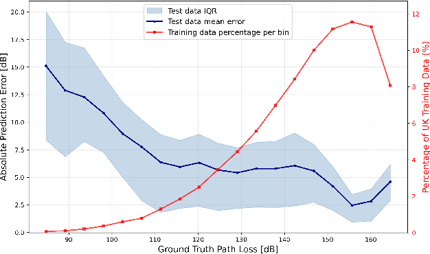
Path loss prediction is a beneficial tool for efficient use of the radio frequency spectrum. Building on prior research on high-resolution map-based path loss models, this paper studies convolutional neural network input representations in more detail. We investigate different methods of representing scalar features in convolutional neural networks. Specifically, we compare using frequency and distance as input channels to convolutional layers or as scalar inputs to regression layers. We assess model performance using three different feature configurations and find that representing scalar features as image channels results in the strongest generalization.
Uncertainty Estimation for Path Loss and Radio Metric Models
Jan 10, 2025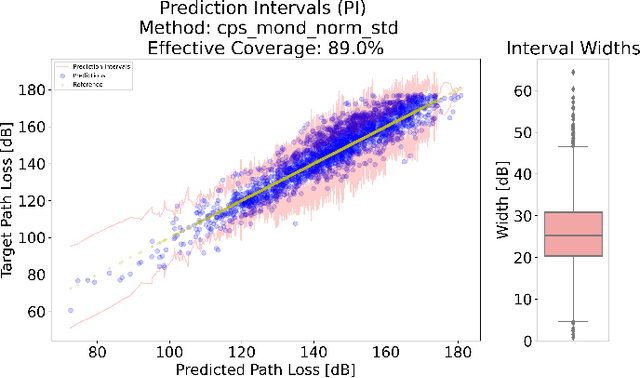
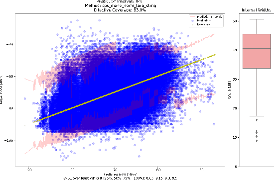
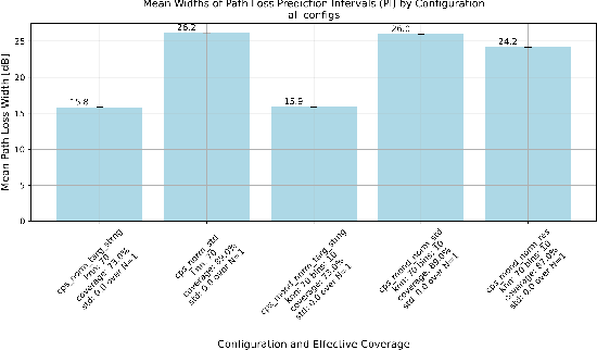
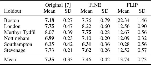
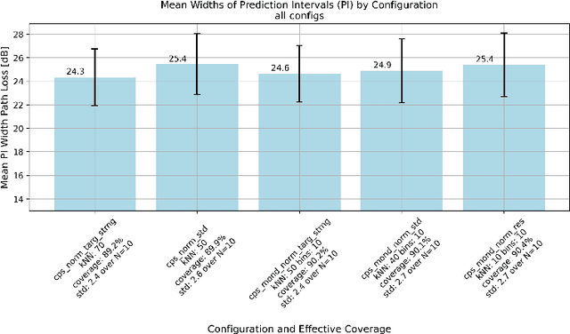
This research leverages Conformal Prediction (CP) in the form of Conformal Predictive Systems (CPS) to accurately estimate uncertainty in a suite of machine learning (ML)-based radio metric models [1] as well as in a 2-D map-based ML path loss model [2]. Utilizing diverse difficulty estimators, we construct 95% confidence prediction intervals (PIs) that are statistically robust. Our experiments demonstrate that CPS models, trained on Toronto datasets, generalize effectively to other cities such as Vancouver and Montreal, maintaining high coverage and reliability. Furthermore, the employed difficulty estimators identify challenging samples, leading to measurable reductions in RMSE as dataset difficulty decreases. These findings highlight the effectiveness of scalable and reliable uncertainty estimation through CPS in wireless network modeling, offering important potential insights for network planning, operations, and spectrum management.
Path Loss Prediction Using Deep Learning
Nov 25, 2024


Radio deployments and spectrum planning can benefit from path loss predictions. Obstructions along a communications link are often considered implicitly or through derived metrics such as representative clutter height or total obstruction depth. In this paper, we propose a path-specific path loss prediction method that uses convolutional neural networks to automatically perform feature extraction from high-resolution obstruction height maps. Our methods result in low prediction error in a variety of environments without requiring derived obstruction metrics.
Conformal Prediction for Multimodal Regression
Oct 25, 2024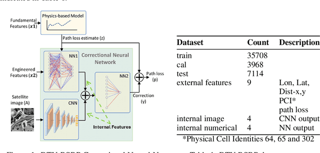
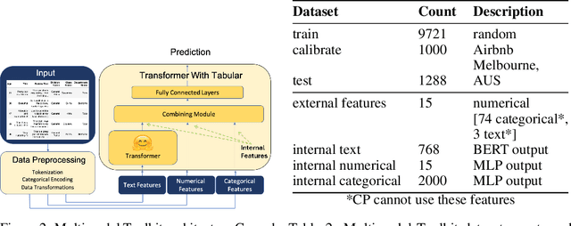
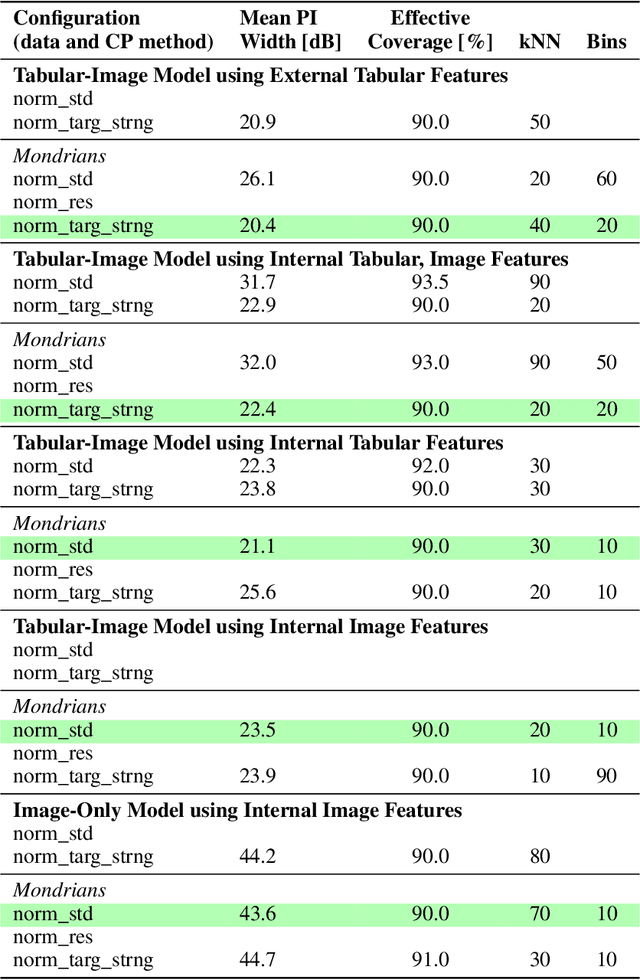
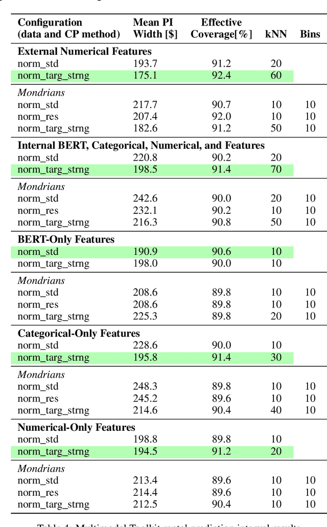
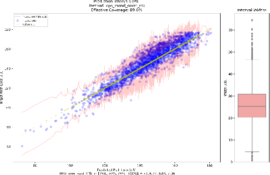
This paper introduces multimodal conformal regression. Traditionally confined to scenarios with solely numerical input features, conformal prediction is now extended to multimodal contexts through our methodology, which harnesses internal features from complex neural network architectures processing images and unstructured text. Our findings highlight the potential for internal neural network features, extracted from convergence points where multimodal information is combined, to be used by conformal prediction to construct prediction intervals (PIs). This capability paves new paths for deploying conformal prediction in domains abundant with multimodal data, enabling a broader range of problems to benefit from guaranteed distribution-free uncertainty quantification.
Target Strangeness: A Novel Conformal Prediction Difficulty Estimator
Oct 24, 2024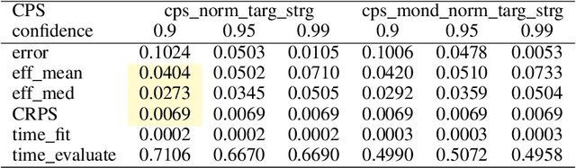
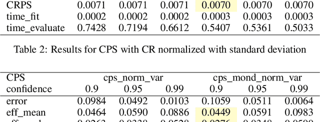
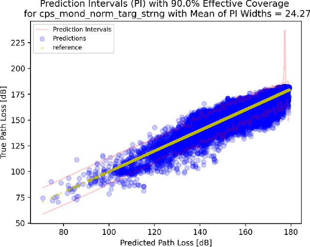
This paper introduces Target Strangeness, a novel difficulty estimator for conformal prediction (CP) that offers an alternative approach for normalizing prediction intervals (PIs). By assessing how atypical a prediction is within the context of its nearest neighbours' target distribution, Target Strangeness can surpass the current state-of-the-art performance. This novel difficulty estimator is evaluated against others in the context of several conformal regression experiments.
Clutter Classification Using Deep Learning in Multiple Stages
Aug 08, 2024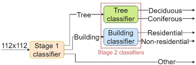
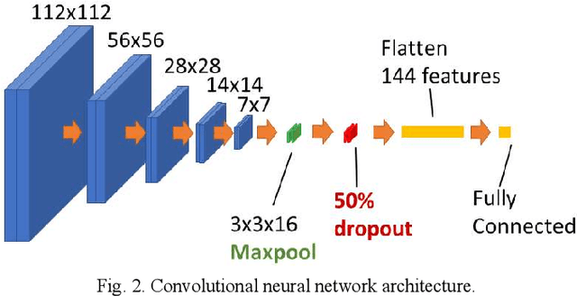
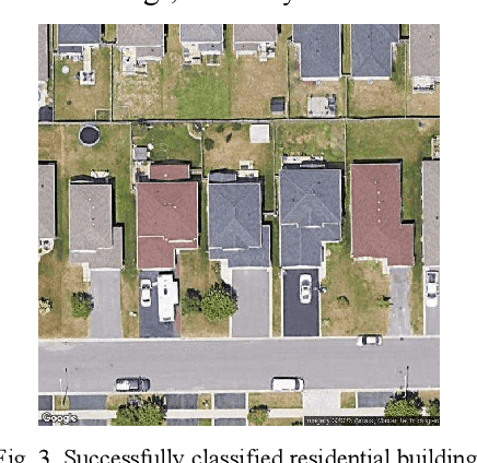
Path loss prediction for wireless communications is highly dependent on the local environment. Propagation models including clutter information have been shown to significantly increase model accuracy. This paper explores the application of deep learning to satellite imagery to identify environmental clutter types automatically. Recognizing these clutter types has numerous uses, but our main application is to use clutter information to enhance propagation prediction models. Knowing the type of obstruction (tree, building, and further classifications) can improve the prediction accuracy of key propagation metrics such as path loss.
* SoutheastCon 2024
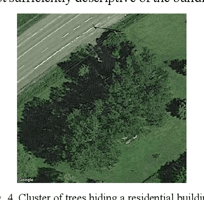
Signal Attenuation through Foliage Estimator (SAFE)
Aug 07, 2024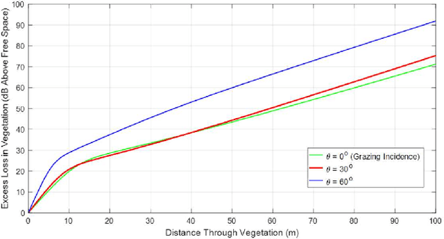
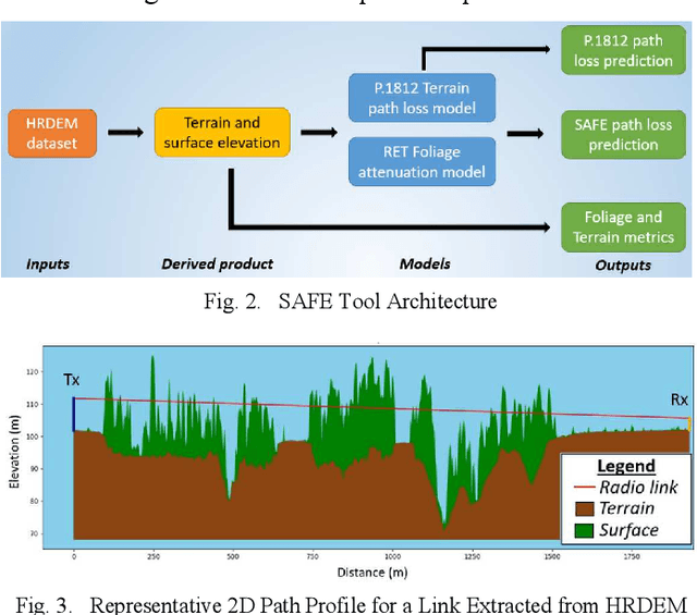
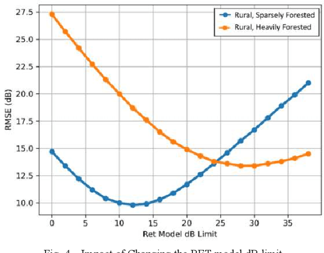
The SAFE tool is an open-source Radio Frequency (RF) propagation model designed for path loss predictions in foliage-dominant environments. It utilizes the ITU-R P.1812-6 model as its backbone, enhances predictions with the physics-based Radiative Energy Transfer (RET) model and makes use of high-resolution terrain and clutter elevation datasets
* Conference