Henrik Karstoft
Motion Informed Object Detection of Small Insects in Time-lapse Camera Recordings
Dec 01, 2022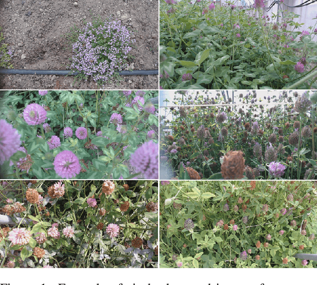
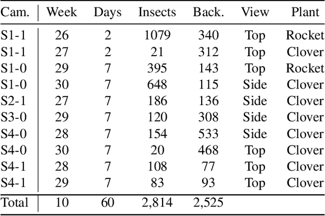
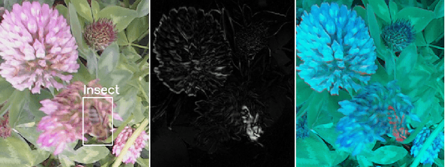
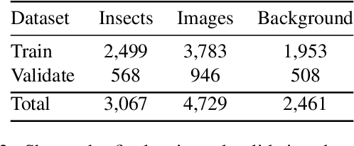
Abstract:Insects as pollinators play a key role in ecosystem management and world food production. However, insect populations are declining, calling for a necessary global demand of insect monitoring. Existing methods analyze video or time-lapse images of insects in nature, but the analysis is challenging since insects are small objects in complex and dynamic scenes of natural vegetation. The current paper provides a dataset of primary honeybees visiting three different plant species during two months of summer-period. The dataset consists of more than 700,000 time-lapse images from multiple cameras, including more than 100,000 annotated images. The paper presents a new method pipeline for detecting insects in time-lapse RGB-images. The pipeline consists of a two-step process. Firstly, the time-lapse RGB-images are preprocessed to enhance insects in the images. We propose a new prepossessing enhancement method: Motion-Informed-enhancement. The technique uses motion and colors to enhance insects in images. The enhanced images are subsequently fed into a Convolutional Neural network (CNN) object detector. Motion-Informed-enhancement improves the deep learning object detectors You Only Look Once (YOLO) and Faster Region-based Convolutional Neural Networks (Faster R-CNN). Using Motion-Informed-enhancement the YOLO-detector improves average micro F1-score from 0.49 to 0.71, and the Faster R-CNN-detector improves average micro F1-score from 0.32 to 0.56 on the our dataset. Our datasets are published on: https://vision.eng.au.dk/mie/
Forecasting large-scale circulation regimes using deformable convolutional neural networks and global spatiotemporal climate data
Feb 10, 2022
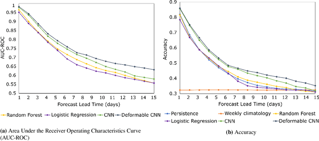
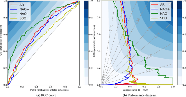
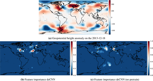
Abstract:Classifying the state of the atmosphere into a finite number of large-scale circulation regimes is a popular way of investigating teleconnections, the predictability of severe weather events, and climate change. Here, we investigate a supervised machine learning approach based on deformable convolutional neural networks (deCNNs) and transfer learning to forecast the North Atlantic-European weather regimes during extended boreal winter for 1 to 15 days into the future. We apply state-of-the-art interpretation techniques from the machine learning literature to attribute particular regions of interest or potential teleconnections relevant for any given weather cluster prediction or regime transition. We demonstrate superior forecasting performance relative to several classical meteorological benchmarks, as well as logistic regression and random forests. Due to its wider field of view, we also observe deCNN achieving considerably better performance than regular convolutional neural networks at lead times beyond 5-6 days. Finally, we find transfer learning to be of paramount importance, similar to previous data-driven atmospheric forecasting studies.
UnsuperPoint: End-to-end Unsupervised Interest Point Detector and Descriptor
Jul 09, 2019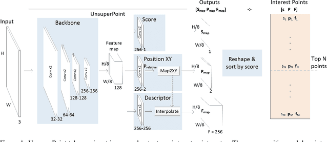
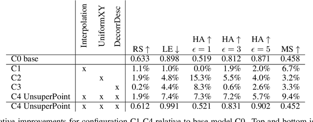
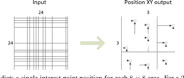
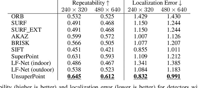
Abstract:It is hard to create consistent ground truth data for interest points in natural images, since interest points are hard to define clearly and consistently for a human annotator. This makes interest point detectors non-trivial to build. In this work, we introduce an unsupervised deep learning-based interest point detector and descriptor. Using a self-supervised approach, we utilize a siamese network and a novel loss function that enables interest point scores and positions to be learned automatically. The resulting interest point detector and descriptor is UnsuperPoint. We use regression of point positions to 1) make UnsuperPoint end-to-end trainable and 2) to incorporate non-maximum suppression in the model. Unlike most trainable detectors, it requires no generation of pseudo ground truth points, no structure-from-motion-generated representations and the model is learned from only one round of training. Furthermore, we introduce a novel loss function to regularize network predictions to be uniformly distributed. UnsuperPoint runs in real-time with 323 frames per second (fps) at a resolution of $224\times320$ and 90 fps at $480\times640$. It is comparable or better than state-of-the-art performance when measured for speed, repeatability, localization, matching score and homography estimation on the HPatch dataset.
FieldSAFE: Dataset for Obstacle Detection in Agriculture
Sep 11, 2017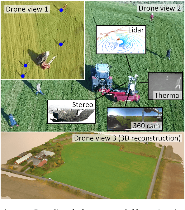

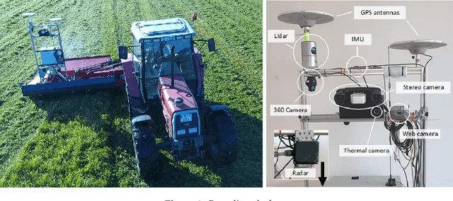

Abstract:In this paper, we present a novel multi-modal dataset for obstacle detection in agriculture. The dataset comprises approximately 2 hours of raw sensor data from a tractor-mounted sensor system in a grass mowing scenario in Denmark, October 2016. Sensing modalities include stereo camera, thermal camera, web camera, 360-degree camera, lidar, and radar, while precise localization is available from fused IMU and GNSS. Both static and moving obstacles are present including humans, mannequin dolls, rocks, barrels, buildings, vehicles, and vegetation. All obstacles have ground truth object labels and geographic coordinates.
* Submitted to special issue of MDPI Sensors: Sensors in Agriculture
 Add to Chrome
 Add to Firefox
 Add to Edge