Haolin Zhang
FAIR: Focused Attention Is All You Need for Generative Recommendation
Dec 17, 2025Abstract:Recently, transformer-based generative recommendation has garnered significant attention for user behavior modeling. However, it often requires discretizing items into multi-code representations (e.g., typically four code tokens or more), which sharply increases the length of the original item sequence. This expansion poses challenges to transformer-based models for modeling user behavior sequences with inherent noises, since they tend to overallocate attention to irrelevant or noisy context. To mitigate this issue, we propose FAIR, the first generative recommendation framework with focused attention, which enhances attention scores to relevant context while suppressing those to irrelevant ones. Specifically, we propose (1) a focused attention mechanism integrated into the standard Transformer, which learns two separate sets of Q and K attention weights and computes their difference as the final attention scores to eliminate attention noise while focusing on relevant contexts; (2) a noise-robustness objective, which encourages the model to maintain stable attention patterns under stochastic perturbations, preventing undesirable shifts toward irrelevant context due to noise; and (3) a mutual information maximization objective, which guides the model to identify contexts that are most informative for next-item prediction. We validate the effectiveness of FAIR on four public benchmarks, demonstrating its superior performance compared to existing methods.
Challenging GPU Dominance: When CPUs Outperform for On-Device LLM Inference
May 09, 2025Abstract:The common assumption in on-device AI is that GPUs, with their superior parallel processing, always provide the best performance for large language model (LLM) inference. In this work, we challenge this notion by empirically demonstrating that, under certain conditions, CPUs can outperform GPUs for LLM inference on mobile devices. Using a 1-billion-parameter LLM deployed via llama.cpp on the iPhone 15 Pro, we show that a CPU-only configuration (two threads, F16 precision) achieves 17 tokens per second, surpassing the 12.8 tokens per second obtained with GPU acceleration. We analyze the architectural factors driving this counterintuitive result, revealing that GPU memory transfer overhead and CPU thread optimization play a critical role. Furthermore, we explore the impact of thread oversubscription, quantization strategies, and hardware constraints, providing new insights into efficient on-device AI execution. Our findings challenge conventional GPU-first thinking, highlighting the untapped potential of optimized CPU inference and paving the way for smarter deployment strategies in mobile AI. However, fully explaining the observed CPU advantage remains difficult due to limited access to low-level profiling tools on iOS.
Leveraging Anchor-based LiDAR 3D Object Detection via Point Assisted Sample Selection
Mar 04, 2024


Abstract:3D object detection based on LiDAR point cloud and prior anchor boxes is a critical technology for autonomous driving environment perception and understanding. Nevertheless, an overlooked practical issue in existing methods is the ambiguity in training sample allocation based on box Intersection over Union (IoU_box). This problem impedes further enhancements in the performance of anchor-based LiDAR 3D object detectors. To tackle this challenge, this paper introduces a new training sample selection method that utilizes point cloud distribution for anchor sample quality measurement, named Point Assisted Sample Selection (PASS). This method has undergone rigorous evaluation on two widely utilized datasets. Experimental results demonstrate that the application of PASS elevates the average precision of anchor-based LiDAR 3D object detectors to a novel state-of-the-art, thereby proving the effectiveness of the proposed approach. The codes will be made available at https://github.com/XJTU-Haolin/Point_Assisted_Sample_Selection.
Map Reconstruction of radio observations with Conditional Invertible Neural Networks
Jun 15, 2023Abstract:In radio astronomy, the challenge of reconstructing a sky map from time ordered data (TOD) is known as an inverse problem. Standard map-making techniques and gridding algorithms are commonly employed to address this problem, each offering its own benefits such as producing minimum-variance maps. However, these approaches also carry limitations such as computational inefficiency and numerical instability in map-making and the inability to remove beam effects in grid-based methods. To overcome these challenges, this study proposes a novel solution through the use of the conditional invertible neural network (cINN) for efficient sky map reconstruction. With the aid of forward modeling, where the simulated TODs are generated from a given sky model with a specific observation, the trained neural network can produce accurate reconstructed sky maps. Using the five-hundred-meter aperture spherical radio telescope (FAST) as an example, cINN demonstrates remarkable performance in map reconstruction from simulated TODs, achieving a mean squared error of $2.29\pm 2.14 \times 10^{-4}~\rm K^2$, a structural similarity index of $0.968\pm0.002$, and a peak signal-to-noise ratio of $26.13\pm5.22$ at the $1\sigma$ level. Furthermore, by sampling in the latent space of cINN, the reconstruction errors for each pixel can be accurately quantified.
3D Harmonic Loss: Towards Task-consistent and Time-friendly 3D Object Detection on Edge for V2X Orchestration
Nov 12, 2022


Abstract:Edge computing-based 3D perception has received attention in intelligent transportation systems (ITS) because real-time monitoring of traffic candidates potentially strengthens Vehicle-to-Everything (V2X) orchestration. Thanks to the capability of precisely measuring the depth information on surroundings from LiDAR, the increasing studies focus on lidar-based 3D detection, which significantly promotes the development of 3D perception. Few methods met the real-time requirement of edge deployment because of high computation-intensive operations. Moreover, an inconsistency problem of object detection remains uncovered in the pointcloud domain due to large sparsity. This paper thoroughly analyses this problem, comprehensively roused by recent works on determining inconsistency problems in the image specialisation. Therefore, we proposed a 3D harmonic loss function to relieve the pointcloud based inconsistent predictions. Moreover, the feasibility of 3D harmonic loss is demonstrated from a mathematical optimization perspective. The KITTI dataset and DAIR-V2X-I dataset are used for simulations, and our proposed method considerably improves the performance than benchmark models. Further, the simulative deployment on an edge device (Jetson Xavier TX) validates our proposed model's efficiency.
Predicting Pedestrian Crossing Intention with Feature Fusion and Spatio-Temporal Attention
Apr 12, 2021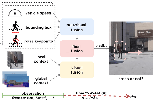
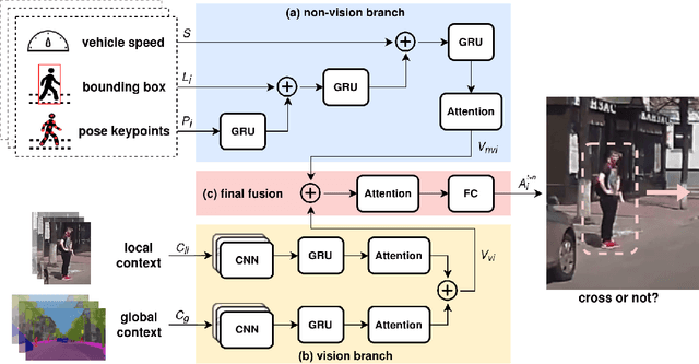
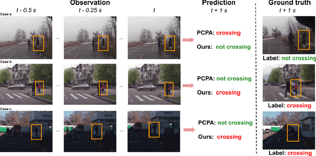
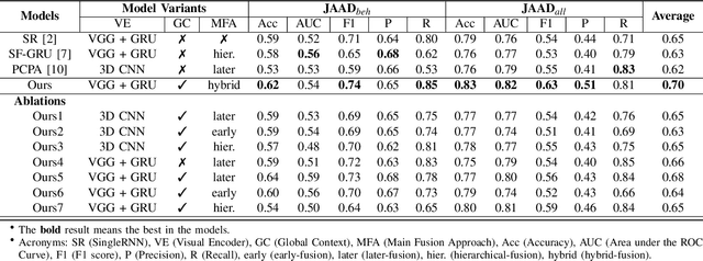
Abstract:Predicting vulnerable road user behavior is an essential prerequisite for deploying Automated Driving Systems (ADS) in the real-world. Pedestrian crossing intention should be recognized in real-time, especially for urban driving. Recent works have shown the potential of using vision-based deep neural network models for this task. However, these models are not robust and certain issues still need to be resolved. First, the global spatio-temproal context that accounts for the interaction between the target pedestrian and the scene has not been properly utilized. Second, the optimum strategy for fusing different sensor data has not been thoroughly investigated. This work addresses the above limitations by introducing a novel neural network architecture to fuse inherently different spatio-temporal features for pedestrian crossing intention prediction. We fuse different phenomena such as sequences of RGB imagery, semantic segmentation masks, and ego-vehicle speed in an optimum way using attention mechanisms and a stack of recurrent neural networks. The optimum architecture was obtained through exhaustive ablation and comparison studies. Extensive comparative experiments on the JAAD pedestrian action prediction benchmark demonstrate the effectiveness of the proposed method, where state-of-the-art performance was achieved. Our code is open-source and publicly available.
Faraway-Frustum: Dealing with Lidar Sparsity for 3D Object Detection using Fusion
Nov 03, 2020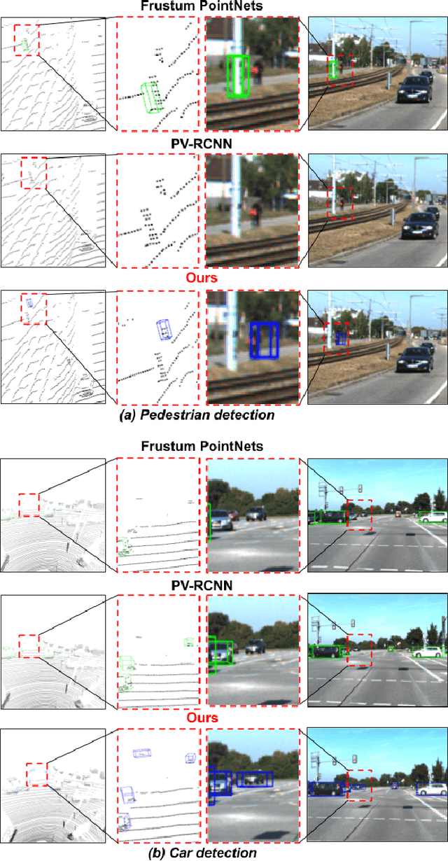
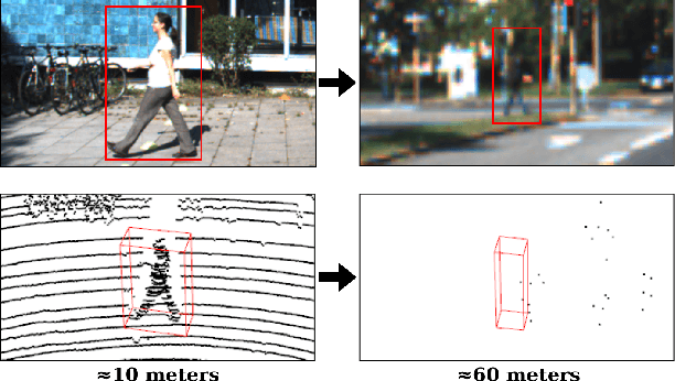

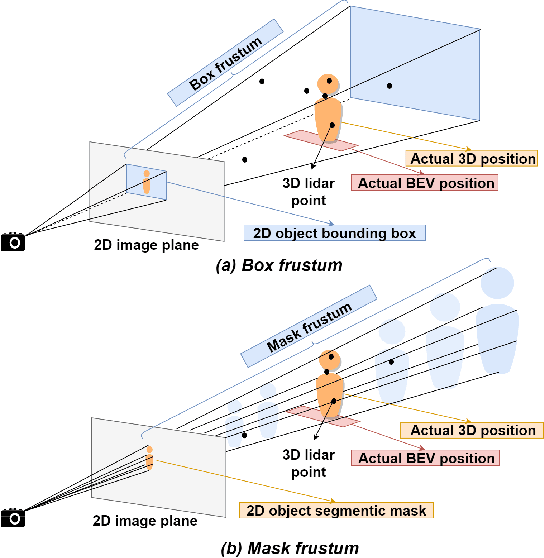
Abstract:Learned pointcloud representations do not generalize well with an increase in distance to the sensor. For example, at a range greater than 60 meters, the sparsity of lidar pointclouds reaches to a point where even humans cannot discern object shapes from each other. However, this distance should not be considered very far for fast-moving vehicles: A vehicle can traverse 60 meters under two seconds while moving at 70 mph. For safe and robust driving automation, acute 3D object detection at these ranges is indispensable. Against this backdrop, we introduce faraway-frustum: a novel fusion strategy for detecting faraway objects. The main strategy is to depend solely on the 2D vision for recognizing object class, as object shape does not change drastically with an increase in depth, and use pointcloud data for object localization in the 3D space for faraway objects. For closer objects, we use learned pointcloud representations instead, following state-of-the-art. This strategy alleviates the main shortcoming of object detection with learned pointcloud representations. Experiments on the KITTI dataset demonstrate that our method outperforms state-of-the-art by a considerable margin for faraway object detection in bird's-eye-view and 3D.
 Add to Chrome
 Add to Firefox
 Add to Edge