Haojia Yu
SenseNova-MARS: Empowering Multimodal Agentic Reasoning and Search via Reinforcement Learning
Dec 30, 2025Abstract:While Vision-Language Models (VLMs) can solve complex tasks through agentic reasoning, their capabilities remain largely constrained to text-oriented chain-of-thought or isolated tool invocation. They fail to exhibit the human-like proficiency required to seamlessly interleave dynamic tool manipulation with continuous reasoning, particularly in knowledge-intensive and visually complex scenarios that demand coordinated external tools such as search and image cropping. In this work, we introduce SenseNova-MARS, a novel Multimodal Agentic Reasoning and Search framework that empowers VLMs with interleaved visual reasoning and tool-use capabilities via reinforcement learning (RL). Specifically, SenseNova-MARS dynamically integrates the image search, text search, and image crop tools to tackle fine-grained and knowledge-intensive visual understanding challenges. In the RL stage, we propose the Batch-Normalized Group Sequence Policy Optimization (BN-GSPO) algorithm to improve the training stability and advance the model's ability to invoke tools and reason effectively. To comprehensively evaluate the agentic VLMs on complex visual tasks, we introduce the HR-MMSearch benchmark, the first search-oriented benchmark composed of high-resolution images with knowledge-intensive and search-driven questions. Experiments demonstrate that SenseNova-MARS achieves state-of-the-art performance on open-source search and fine-grained image understanding benchmarks. Specifically, on search-oriented benchmarks, SenseNova-MARS-8B scores 67.84 on MMSearch and 41.64 on HR-MMSearch, surpassing proprietary models such as Gemini-3-Flash and GPT-5. SenseNova-MARS represents a promising step toward agentic VLMs by providing effective and robust tool-use capabilities. To facilitate further research in this field, we will release all code, models, and datasets.
SuperpixelGraph: Semi-automatic generation of building footprint through semantic-sensitive superpixel and neural graph networks
Apr 12, 2023


Abstract:Most urban applications necessitate building footprints in the form of concise vector graphics with sharp boundaries rather than pixel-wise raster images. This need contrasts with the majority of existing methods, which typically generate over-smoothed footprint polygons. Editing these automatically produced polygons can be inefficient, if not more time-consuming than manual digitization. This paper introduces a semi-automatic approach for building footprint extraction through semantically-sensitive superpixels and neural graph networks. Drawing inspiration from object-based classification techniques, we first learn to generate superpixels that are not only boundary-preserving but also semantically-sensitive. The superpixels respond exclusively to building boundaries rather than other natural objects, while simultaneously producing semantic segmentation of the buildings. These intermediate superpixel representations can be naturally considered as nodes within a graph. Consequently, graph neural networks are employed to model the global interactions among all superpixels and enhance the representativeness of node features for building segmentation. Classical approaches are utilized to extract and regularize boundaries for the vectorized building footprints. Utilizing minimal clicks and straightforward strokes, we efficiently accomplish accurate segmentation outcomes, eliminating the necessity for editing polygon vertices. Our proposed approach demonstrates superior precision and efficacy, as validated by experimental assessments on various public benchmark datasets. We observe a 10\% enhancement in the metric for superpixel clustering and an 8\% increment in vector graphics evaluation, when compared with established techniques. Additionally, we have devised an optimized and sophisticated pipeline for interactive editing, poised to further augment the overall quality of the results.
Semantic Image Translation for Repairing the Texture Defects of Building Models
Apr 01, 2023Abstract:The accurate representation of 3D building models in urban environments is significantly hindered by challenges such as texture occlusion, blurring, and missing details, which are difficult to mitigate through standard photogrammetric texture mapping pipelines. Current image completion methods often struggle to produce structured results and effectively handle the intricate nature of highly-structured fa\c{c}ade textures with diverse architectural styles. Furthermore, existing image synthesis methods encounter difficulties in preserving high-frequency details and artificial regular structures, which are essential for achieving realistic fa\c{c}ade texture synthesis. To address these challenges, we introduce a novel approach for synthesizing fa\c{c}ade texture images that authentically reflect the architectural style from a structured label map, guided by a ground-truth fa\c{c}ade image. In order to preserve fine details and regular structures, we propose a regularity-aware multi-domain method that capitalizes on frequency information and corner maps. We also incorporate SEAN blocks into our generator to enable versatile style transfer. To generate plausible structured images without undesirable regions, we employ image completion techniques to remove occlusions according to semantics prior to image inference. Our proposed method is also capable of synthesizing texture images with specific styles for fa\c{c}ades that lack pre-existing textures, using manually annotated labels. Experimental results on publicly available fa\c{c}ade image and 3D model datasets demonstrate that our method yields superior results and effectively addresses issues associated with flawed textures. The code and datasets will be made publicly available for further research and development.
Meta-learning an Intermediate Representation for Few-shot Block-wise Prediction of Landslide Susceptibility
Oct 03, 2021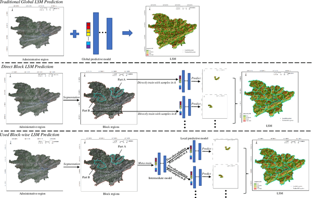
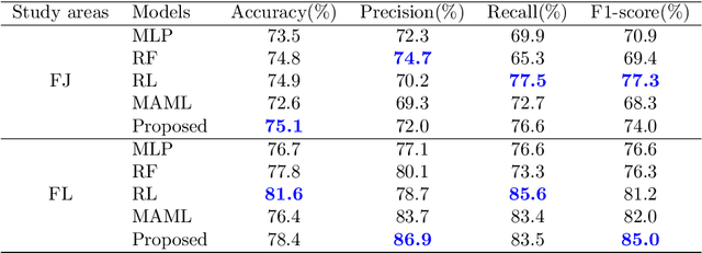
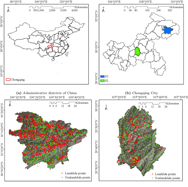
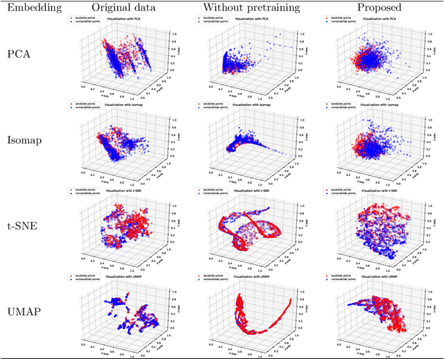
Abstract:Predicting a landslide susceptibility map (LSM) is essential for risk recognition and disaster prevention. Despite the successful application of data-driven prediction approaches, current data-driven methods generally apply a single global model to predict the LSM for an entire target region. However, we argue that, in complex circumstances, especially in large-scale areas, each part of the region holds different landslide-inducing environments, and therefore, should be predicted individually with respective models. In this study, target scenarios were segmented into blocks for individual analysis using topographical factors. But simply conducting training and testing using limited samples within each block is hardly possible for a satisfactory LSM prediction, due to the adverse effect of \textit{overfitting}. To solve the problems, we train an intermediate representation by the meta-learning paradigm, which is superior for capturing information from LSM tasks in order to generalize proficiently. We chose this based on the hypothesis that there are more general concepts among LSM tasks that are sensitive to variations in input features. Thus, using the intermediate representation, we can easily adapt the model for different blocks or even unseen tasks using few exemplar samples. Experimental results on two study areas demonstrated the validity of our block-wise analysis in large scenarios and revealed the top few-shot adaption performances of the proposed methods.
Structure-Aware Completion of Photogrammetric Meshes in Urban Road Environment
Nov 24, 2020

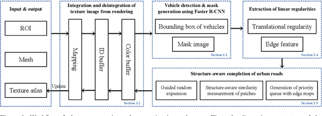

Abstract:Photogrammetric mesh models obtained from aerial oblique images have been widely used for urban reconstruction. However, the photogrammetric meshes also suffer from severe texture problems, especially on the road areas due to occlusion. This paper proposes a structure-aware completion approach to improve the quality of meshes by removing undesired vehicles on the road seamlessly. Specifically, the discontinuous texture atlas is first integrated to a continuous screen space through rendering by the graphics pipeline; the rendering also records necessary mapping for deintegration to the original texture atlas after editing. Vehicle regions are masked by a standard object detection approach, e.g. Faster RCNN. Then, the masked regions are completed guided by the linear structures and regularities in the road region, which is implemented based on Patch Match. Finally, the completed rendered image is deintegrated to the original texture atlas and the triangles for the vehicles are also flattened for improved meshes. Experimental evaluations and analyses are conducted against three datasets, which are captured with different sensors and ground sample distances. The results reveal that the proposed method can quite realistic meshes after removing the vehicles. The structure-aware completion approach for road regions outperforms popular image completion methods and ablation study further confirms the effectiveness of the linear guidance. It should be noted that the proposed method is also capable to handle tiled mesh models for large-scale scenes. Dataset and code are available at vrlab.org.cn/~hanhu/projects/mesh.
 Add to Chrome
 Add to Firefox
 Add to Edge