Guozhang Liu
Dynamic Loss Decay based Robust Oriented Object Detection on Remote Sensing Images with Noisy Labels
May 15, 2024


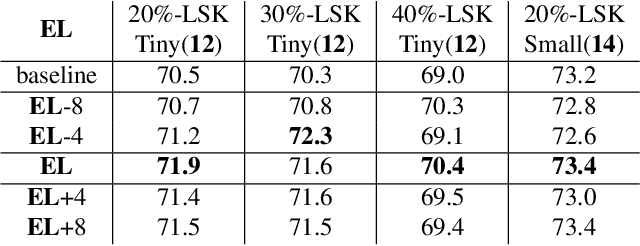
Abstract:The ambiguous appearance, tiny scale, and fine-grained classes of objects in remote sensing imagery inevitably lead to the noisy annotations in category labels of detection dataset. However, the effects and treatments of the label noises are underexplored in modern oriented remote sensing object detectors. To address this issue, we propose a robust oriented remote sensing object detection method through dynamic loss decay (DLD) mechanism, inspired by the two phase ``early-learning'' and ``memorization'' learning dynamics of deep neural networks on clean and noisy samples. To be specific, we first observe the end point of early learning phase termed as EL, after which the models begin to memorize the false labels that significantly degrade the detection accuracy. Secondly, under the guidance of the training indicator, the losses of each sample are ranked in descending order, and we adaptively decay the losses of the top K largest ones (bad samples) in the following epochs. Because these large losses are of high confidence to be calculated with wrong labels. Experimental results show that the method achieves excellent noise resistance performance tested on multiple public datasets such as HRSC2016 and DOTA-v1.0/v2.0 with synthetic category label noise. Our solution also has won the 2st place in the "fine-grained object detection based on sub-meter remote sensing imagery" track with noisy labels of 2023 National Big Data and Computing Intelligence Challenge.
HGDNet: A Height-Hierarchy Guided Dual-Decoder Network for Single View Building Extraction and Height Estimation
Aug 10, 2023


Abstract:Unifying the correlative single-view satellite image building extraction and height estimation tasks indicates a promising way to share representations and acquire generalist model for large-scale urban 3D reconstruction. However, the common spatial misalignment between building footprints and stereo-reconstructed nDSM height labels incurs degraded performance on both tasks. To address this issue, we propose a Height-hierarchy Guided Dual-decoder Network (HGDNet) to estimate building height. Under the guidance of synthesized discrete height-hierarchy nDSM, auxiliary height-hierarchical building extraction branch enhance the height estimation branch with implicit constraints, yielding an accuracy improvement of more than 6% on the DFC 2023 track2 dataset. Additional two-stage cascade architecture is adopted to achieve more accurate building extraction. Experiments on the DFC 2023 Track 2 dataset shows the superiority of the proposed method in building height estimation ({\delta}1:0.8012), instance extraction (AP50:0.7730), and the final average score 0.7871 ranks in the first place in test phase.
Fine-grained building roof instance segmentation based on domain adapted pretraining and composite dual-backbone
Aug 10, 2023Abstract:The diversity of building architecture styles of global cities situated on various landforms, the degraded optical imagery affected by clouds and shadows, and the significant inter-class imbalance of roof types pose challenges for designing a robust and accurate building roof instance segmentor. To address these issues, we propose an effective framework to fulfill semantic interpretation of individual buildings with high-resolution optical satellite imagery. Specifically, the leveraged domain adapted pretraining strategy and composite dual-backbone greatly facilitates the discriminative feature learning. Moreover, new data augmentation pipeline, stochastic weight averaging (SWA) training and instance segmentation based model ensemble in testing are utilized to acquire additional performance boost. Experiment results show that our approach ranks in the first place of the 2023 IEEE GRSS Data Fusion Contest (DFC) Track 1 test phase ($mAP_{50}$:50.6\%). Note-worthily, we have also explored the potential of multimodal data fusion with both optical satellite imagery and SAR data.
 Add to Chrome
 Add to Firefox
 Add to Edge