Gianluca Monaci
What does really matter in image goal navigation?
Jul 02, 2025Abstract:Image goal navigation requires two different skills: firstly, core navigation skills, including the detection of free space and obstacles, and taking decisions based on an internal representation; and secondly, computing directional information by comparing visual observations to the goal image. Current state-of-the-art methods either rely on dedicated image-matching, or pre-training of computer vision modules on relative pose estimation. In this paper, we study whether this task can be efficiently solved with end-to-end training of full agents with RL, as has been claimed by recent work. A positive answer would have impact beyond Embodied AI and allow training of relative pose estimation from reward for navigation alone. In a large study we investigate the effect of architectural choices like late fusion, channel stacking, space-to-depth projections and cross-attention, and their role in the emergence of relative pose estimators from navigation training. We show that the success of recent methods is influenced up to a certain extent by simulator settings, leading to shortcuts in simulation. However, we also show that these capabilities can be transferred to more realistic setting, up to some extend. We also find evidence for correlations between navigation performance and probed (emerging) relative pose estimation performance, an important sub skill.
RANa: Retrieval-Augmented Navigation
Apr 04, 2025Abstract:Methods for navigation based on large-scale learning typically treat each episode as a new problem, where the agent is spawned with a clean memory in an unknown environment. While these generalization capabilities to an unknown environment are extremely important, we claim that, in a realistic setting, an agent should have the capacity of exploiting information collected during earlier robot operations. We address this by introducing a new retrieval-augmented agent, trained with RL, capable of querying a database collected from previous episodes in the same environment and learning how to integrate this additional context information. We introduce a unique agent architecture for the general navigation task, evaluated on ObjectNav, ImageNav and Instance-ImageNav. Our retrieval and context encoding methods are data-driven and heavily employ vision foundation models (FM) for both semantic and geometric understanding. We propose new benchmarks for these settings and we show that retrieval allows zero-shot transfer across tasks and environments while significantly improving performance.
Reasoning in visual navigation of end-to-end trained agents: a dynamical systems approach
Mar 12, 2025Abstract:Progress in Embodied AI has made it possible for end-to-end-trained agents to navigate in photo-realistic environments with high-level reasoning and zero-shot or language-conditioned behavior, but benchmarks are still dominated by simulation. In this work, we focus on the fine-grained behavior of fast-moving real robots and present a large-scale experimental study involving \numepisodes{} navigation episodes in a real environment with a physical robot, where we analyze the type of reasoning emerging from end-to-end training. In particular, we study the presence of realistic dynamics which the agent learned for open-loop forecasting, and their interplay with sensing. We analyze the way the agent uses latent memory to hold elements of the scene structure and information gathered during exploration. We probe the planning capabilities of the agent, and find in its memory evidence for somewhat precise plans over a limited horizon. Furthermore, we show in a post-hoc analysis that the value function learned by the agent relates to long-term planning. Put together, our experiments paint a new picture on how using tools from computer vision and sequential decision making have led to new capabilities in robotics and control. An interactive tool is available at europe.naverlabs.com/research/publications/reasoning-in-visual-navigation-of-end-to-end-trained-agents.
Zero-BEV: Zero-shot Projection of Any First-Person Modality to BEV Maps
Feb 21, 2024Abstract:Bird's-eye view (BEV) maps are an important geometrically structured representation widely used in robotics, in particular self-driving vehicles and terrestrial robots. Existing algorithms either require depth information for the geometric projection, which is not always reliably available, or are trained end-to-end in a fully supervised way to map visual first-person observations to BEV representation, and are therefore restricted to the output modality they have been trained for. In contrast, we propose a new model capable of performing zero-shot projections of any modality available in a first person view to the corresponding BEV map. This is achieved by disentangling the geometric inverse perspective projection from the modality transformation, eg. RGB to occupancy. The method is general and we showcase experiments projecting to BEV three different modalities: semantic segmentation, motion vectors and object bounding boxes detected in first person. We experimentally show that the model outperforms competing methods, in particular the widely used baseline resorting to monocular depth estimation.
Learning to navigate efficiently and precisely in real environments
Jan 25, 2024Abstract:In the context of autonomous navigation of terrestrial robots, the creation of realistic models for agent dynamics and sensing is a widespread habit in the robotics literature and in commercial applications, where they are used for model based control and/or for localization and mapping. The more recent Embodied AI literature, on the other hand, focuses on modular or end-to-end agents trained in simulators like Habitat or AI-Thor, where the emphasis is put on photo-realistic rendering and scene diversity, but high-fidelity robot motion is assigned a less privileged role. The resulting sim2real gap significantly impacts transfer of the trained models to real robotic platforms. In this work we explore end-to-end training of agents in simulation in settings which minimize the sim2real gap both, in sensing and in actuation. Our agent directly predicts (discretized) velocity commands, which are maintained through closed-loop control in the real robot. The behavior of the real robot (including the underlying low-level controller) is identified and simulated in a modified Habitat simulator. Noise models for odometry and localization further contribute in lowering the sim2real gap. We evaluate on real navigation scenarios, explore different localization and point goal calculation methods and report significant gains in performance and robustness compared to prior work.
Learning whom to trust in navigation: dynamically switching between classical and neural planning
Jul 31, 2023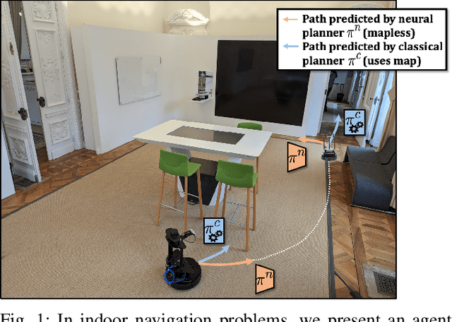
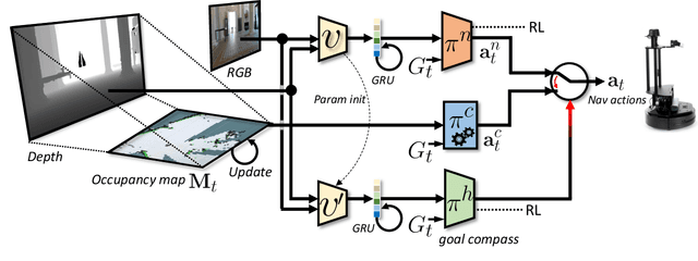
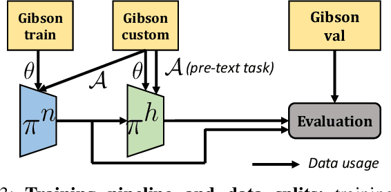
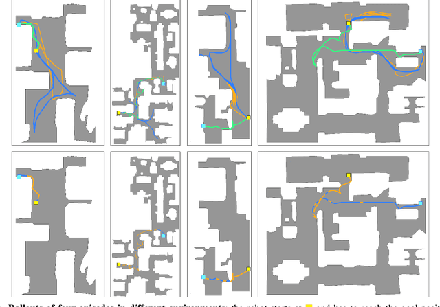
Abstract:Navigation of terrestrial robots is typically addressed either with localization and mapping (SLAM) followed by classical planning on the dynamically created maps, or by machine learning (ML), often through end-to-end training with reinforcement learning (RL) or imitation learning (IL). Recently, modular designs have achieved promising results, and hybrid algorithms that combine ML with classical planning have been proposed. Existing methods implement these combinations with hand-crafted functions, which cannot fully exploit the complementary nature of the policies and the complex regularities between scene structure and planning performance. Our work builds on the hypothesis that the strengths and weaknesses of neural planners and classical planners follow some regularities, which can be learned from training data, in particular from interactions. This is grounded on the assumption that, both, trained planners and the mapping algorithms underlying classical planning are subject to failure cases depending on the semantics of the scene and that this dependence is learnable: for instance, certain areas, objects or scene structures can be reconstructed easier than others. We propose a hierarchical method composed of a high-level planner dynamically switching between a classical and a neural planner. We fully train all neural policies in simulation and evaluate the method in both simulation and real experiments with a LoCoBot robot, showing significant gains in performance, in particular in the real environment. We also qualitatively conjecture on the nature of data regularities exploited by the high-level planner.
Learning with a Mole: Transferable latent spatial representations for navigation without reconstruction
Jun 06, 2023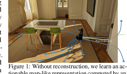

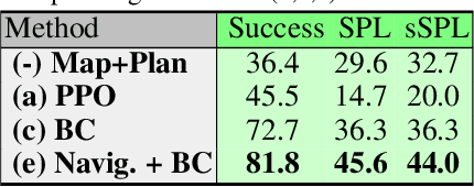
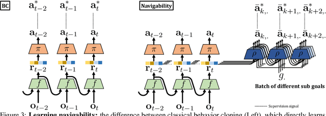
Abstract:Agents navigating in 3D environments require some form of memory, which should hold a compact and actionable representation of the history of observations useful for decision taking and planning. In most end-to-end learning approaches the representation is latent and usually does not have a clearly defined interpretation, whereas classical robotics addresses this with scene reconstruction resulting in some form of map, usually estimated with geometry and sensor models and/or learning. In this work we propose to learn an actionable representation of the scene independently of the targeted downstream task and without explicitly optimizing reconstruction. The learned representation is optimized by a blind auxiliary agent trained to navigate with it on multiple short sub episodes branching out from a waypoint and, most importantly, without any direct visual observation. We argue and show that the blindness property is important and forces the (trained) latent representation to be the only means for planning. With probing experiments we show that the learned representation optimizes navigability and not reconstruction. On downstream tasks we show that it is robust to changes in distribution, in particular the sim2real gap, which we evaluate with a real physical robot in a real office building, significantly improving performance.
 Add to Chrome
 Add to Firefox
 Add to Edge