Daniel Hodczak
ELSA: Evaluating Localization of Social Activities in Urban Streets
Jun 03, 2024


Abstract:Why do some streets attract more social activities than others? Is it due to street design, or do land use patterns in neighborhoods create opportunities for businesses where people gather? These questions have intrigued urban sociologists, designers, and planners for decades. Yet, most research in this area has remained limited in scale, lacking a comprehensive perspective on the various factors influencing social interactions in urban settings. Exploring these issues requires fine-level data on the frequency and variety of social interactions on urban street. Recent advances in computer vision and the emergence of the open-vocabulary detection models offer a unique opportunity to address this long-standing issue on a scale that was previously impossible using traditional observational methods. In this paper, we propose a new benchmark dataset for Evaluating Localization of Social Activities (ELSA) in urban street images. ELSA draws on theoretical frameworks in urban sociology and design. While majority of action recognition datasets are collected in controlled settings, we use in-the-wild street-level imagery, where the size of social groups and the types of activities can vary significantly. ELSA includes 937 manually annotated images with more than 4,300 multi-labeled bounding boxes for individual and group activities, categorized into three primary groups: Condition, State, and Action. Each category contains various sub-categories, e.g., alone or group under Condition category, standing or walking, which fall under the State category, and talking or dining with regards to the Action category. ELSA is publicly available for the research community.
Deep Umbra: A Generative Approach for Sunlight Access Computation in Urban Spaces
Feb 27, 2024


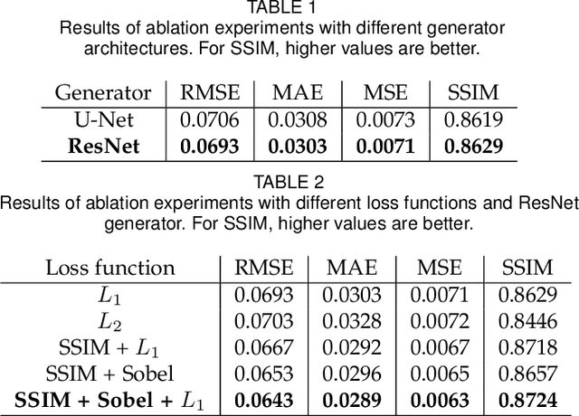
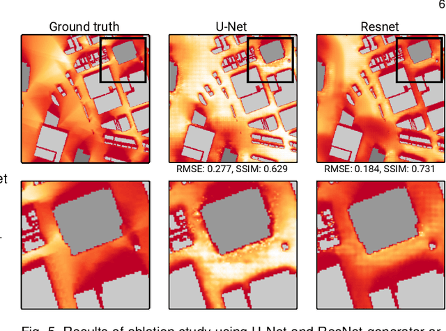
Abstract:Sunlight and shadow play critical roles in how urban spaces are utilized, thrive, and grow. While access to sunlight is essential to the success of urban environments, shadows can provide shaded places to stay during the hot seasons, mitigate heat island effect, and increase pedestrian comfort levels. Properly quantifying sunlight access and shadows in large urban environments is key in tackling some of the important challenges facing cities today. In this paper, we propose Deep Umbra, a novel computational framework that enables the quantification of sunlight access and shadows at a global scale. Our framework is based on a conditional generative adversarial network that considers the physical form of cities to compute high-resolution spatial information of accumulated sunlight access for the different seasons of the year. We use data from seven different cities to train our model, and show, through an extensive set of experiments, its low overall RMSE (below 0.1) as well as its extensibility to cities that were not part of the training set. Additionally, we contribute a set of case studies and a comprehensive dataset with sunlight access information for more than 100 cities across six continents of the world. Deep Umbra is available at https://urbantk.org/shadows.
 Add to Chrome
 Add to Firefox
 Add to Edge