 Add to Chrome
 Add to Firefox
 Add to Edge
SkyReels-V4: Multi-modal Video-Audio Generation, Inpainting and Editing model
Feb 26, 2026SkyReels V4 is a unified multi modal video foundation model for joint video audio generation, inpainting, and editing. The model adopts a dual stream Multimodal Diffusion Transformer (MMDiT) architecture, where one branch synthesizes video and the other generates temporally aligned audio, while sharing a powerful text encoder based on the Multimodal Large Language Models (MMLM). SkyReels V4 accepts rich multi modal instructions, including text, images, video clips, masks, and audio references. By combining the MMLMs multi modal instruction following capability with in context learning in the video branch MMDiT, the model can inject fine grained visual guidance under complex conditioning, while the audio branch MMDiT simultaneously leverages audio references to guide sound generation. On the video side, we adopt a channel concatenation formulation that unifies a wide range of inpainting style tasks, such as image to video, video extension, and video editing under a single interface, and naturally extends to vision referenced inpainting and editing via multi modal prompts. SkyReels V4 supports up to 1080p resolution, 32 FPS, and 15 second duration, enabling high fidelity, multi shot, cinema level video generation with synchronized audio. To make such high resolution, long-duration generation computationally feasible, we introduce an efficiency strategy: Joint generation of low resolution full sequences and high-resolution keyframes, followed by dedicated super-resolution and frame interpolation models. To our knowledge, SkyReels V4 is the first video foundation model that simultaneously supports multi-modal input, joint video audio generation, and a unified treatment of generation, inpainting, and editing, while maintaining strong efficiency and quality at cinematic resolutions and durations.
Retrieval Based Time Series Forecasting
Sep 27, 2022
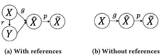
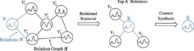
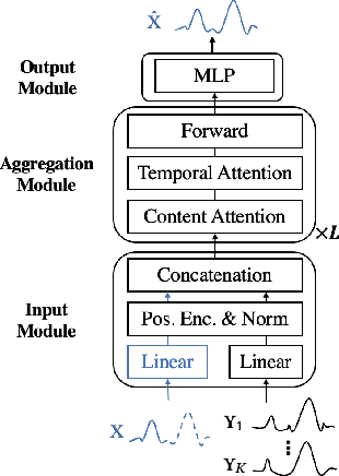
Time series data appears in a variety of applications such as smart transportation and environmental monitoring. One of the fundamental problems for time series analysis is time series forecasting. Despite the success of recent deep time series forecasting methods, they require sufficient observation of historical values to make accurate forecasting. In other words, the ratio of the output length (or forecasting horizon) to the sum of the input and output lengths should be low enough (e.g., 0.3). As the ratio increases (e.g., to 0.8), the uncertainty for the forecasting accuracy increases significantly. In this paper, we show both theoretically and empirically that the uncertainty could be effectively reduced by retrieving relevant time series as references. In the theoretical analysis, we first quantify the uncertainty and show its connections to the Mean Squared Error (MSE). Then we prove that models with references are easier to learn than models without references since the retrieved references could reduce the uncertainty. To empirically demonstrate the effectiveness of the retrieval based time series forecasting models, we introduce a simple yet effective two-stage method, called ReTime consisting of a relational retrieval and a content synthesis. We also show that ReTime can be easily adapted to the spatial-temporal time series and time series imputation settings. Finally, we evaluate ReTime on real-world datasets to demonstrate its effectiveness.
ROLL: Long-Term Robust LiDAR-based Localization With Temporary Mapping in Changing Environments
Mar 08, 2022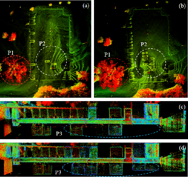
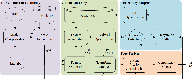
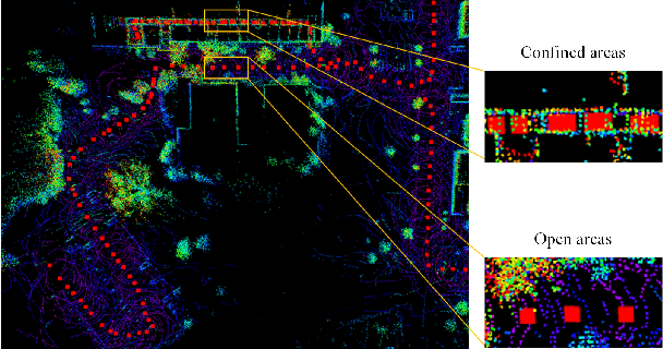
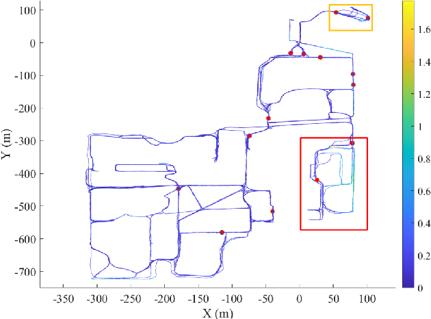
Long-term scene changes present challenges to localization systems using a pre-built map. This paper presents a LiDAR-based system that can provide robust localization against those challenges. Our method starts with activation of a mapping process temporarily when global matching towards the pre-built map is unreliable. The temporary map will be merged onto the pre-built map for later localization runs once reliable matching is obtained again. We further integrate a LiDAR inertial odometry (LIO) to provide motion-compensated LiDAR scans and a reliable initial pose guess for the global matching module. To generate a smooth real-time trajectory for navigation purposes, we fuse poses from odometry and global matching by solving a pose graph optimization problem. We evaluate our localization system with extensive experiments on the NCLT dataset including a variety of changing indoor and outdoor environments, and the results demonstrate a robust and accurate localization performance for over a year. The implementations are open sourced on GitHub.