 Add to Chrome
 Add to Firefox
 Add to Edge
Recursive classification of satellite imaging time-series: An application to water and land cover mapping
Paper and Code
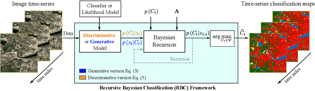
A wide variety of applications of fundamental importance for security, environmental protection and urban development need access to accurate land cover monitoring and water mapping, for which the analysis of optical remote sensing imagery is key. Classification of time-series images, particularly with recursive methods, is of increasing interest in the current literature. Nevertheless, existing recursive approaches typically require large amounts of training data. This paper introduces a recursive classification framework that provides high accuracy while requiring low computational cost and minimal supervision. The proposed approach transforms a static classifier into a recursive one using a probabilistic framework that is robust to non-informative image variations. A water mapping and a land cover experiment are conducted analyzing Sentinel-2 satellite data covering two areas in the United States. The performance of three static classification algorithms and their recursive versions is compared, including a Gaussian Mixture Model (GMM), Logistic Regression (LR) and Spectral Index Classifiers (SICs). SICs consist in a new approach that we introduce to convert the Modified Normalized Difference Water Index (MNDWI) and the Normalized Difference Vegetation Index (NDVI) into probabilistic classification results. Two state-of-the-art deep learning-based classifiers are also used as benchmark models. Results show that the proposed method significantly increases the robustness of existing static classifiers in multitemporal settings. Our method also improves the performance of deep learning-based classifiers without the need of additional training data.