Sihan Zhu
Multi-Level LVLM Guidance for Untrimmed Video Action Recognition
Aug 24, 2025Abstract:Action recognition and localization in complex, untrimmed videos remain a formidable challenge in computer vision, largely due to the limitations of existing methods in capturing fine-grained actions, long-term temporal dependencies, and high-level semantic information from low-level visual features. This paper introduces the Event-Contextualized Video Transformer (ECVT), a novel architecture that leverages the advanced semantic understanding capabilities of Large Vision-Language Models (LVLMs) to bridge this gap. ECVT employs a dual-branch design, comprising a Video Encoding Branch for spatio-temporal feature extraction and a Cross-Modal Guidance Branch. The latter utilizes an LVLM to generate multi-granularity semantic descriptions, including Global Event Prompting for macro-level narrative and Temporal Sub-event Prompting for fine-grained action details. These multi-level textual cues are integrated into the video encoder's learning process through sophisticated mechanisms such as adaptive gating for high-level semantic fusion, cross-modal attention for fine-grained feature refinement, and an event graph module for temporal context calibration. Trained end-to-end with a comprehensive loss function incorporating semantic consistency and temporal calibration terms, ECVT significantly enhances the model's ability to understand video temporal structures and event logic. Extensive experiments on ActivityNet v1.3 and THUMOS14 datasets demonstrate that ECVT achieves state-of-the-art performance, with an average mAP of 40.5% on ActivityNet v1.3 and mAP@0.5 of 67.1% on THUMOS14, outperforming leading baselines.
Transportation Density Reduction Caused by City Lockdowns Across the World during the COVID-19 Epidemic: From the View of High-resolution Remote Sensing Imagery
Mar 02, 2021


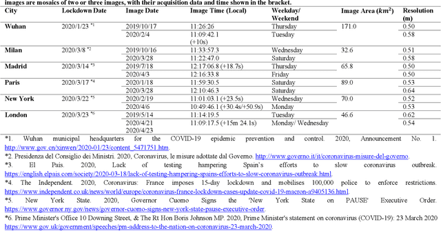
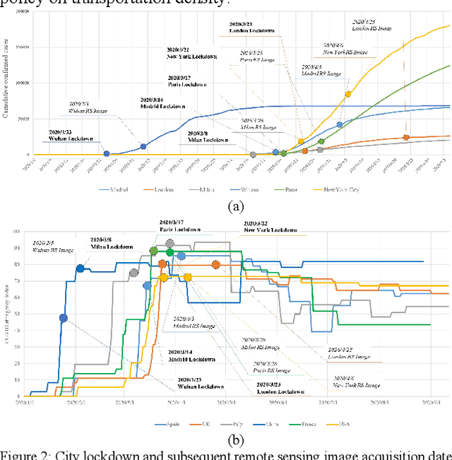
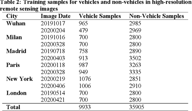
Abstract:As the COVID-19 epidemic began to worsen in the first months of 2020, stringent lockdown policies were implemented in numerous cities throughout the world to control human transmission and mitigate its spread. Although transportation density reduction inside the city was felt subjectively, there has thus far been no objective and quantitative study of its variation to reflect the intracity population flows and their corresponding relationship with lockdown policy stringency from the view of remote sensing images with the high resolution under 1m. Accordingly, we here provide a quantitative investigation of the transportation density reduction before and after lockdown was implemented in six epicenter cities (Wuhan, Milan, Madrid, Paris, New York, and London) around the world during the COVID-19 epidemic, which is accomplished by extracting vehicles from the multi-temporal high-resolution remote sensing images. A novel vehicle detection model combining unsupervised vehicle candidate extraction and deep learning identification was specifically proposed for the images with the resolution of 0.5m. Our results indicate that transportation densities were reduced by an average of approximately 50% (and as much as 75.96%) in these six cities following lockdown. The influences on transportation density reduction rates are also highly correlated with policy stringency, with an R^2 value exceeding 0.83. Even within a specific city, the transportation density changes differed and tended to be distributed in accordance with the city's land-use patterns. Considering that public transportation was mostly reduced or even forbidden, our results indicate that city lockdown policies are effective at limiting human transmission within cities.
 Add to Chrome
 Add to Firefox
 Add to Edge