Safwan Wshah
Spatially-Adaptive Conformal Graph Transformer for Indoor Localization in Wi-Fi Driven Networks
Jan 29, 2026Abstract:Indoor localization is a critical enabler for a wide range of location-based services in smart environments, including navigation, asset tracking, and safety-critical applications. Recent graph-based models leverage spatial relationships between Wire-less Fidelity (Wi-Fi) Access Points (APs) and devices, offering finer localization granularity, but fall short in quantifying prediction uncertainty, a key requirement for real-world deployment. In this paper, we propose Spatially-Adaptive Conformal Graph Transformer (SAC-GT), a framework for accurate and reliable indoor localization. SAC-GT integrates a Graph Transformer (GT) model that captures network's spatial topology and signal strength dynamics, with a novel Spatially-Adaptive Conformal Prediction (SACP) method that provides region-specific uncertainty estimates. This allows SAC-GT to produce not only precise two-dimensional (2D) location predictions but also statistically valid confidence regions tailored to varying environmental conditions. Extensive evaluations on a large-scale real-world dataset demonstrate that the proposed SAC-GT solution achieves state-of-the-art localization accuracy while delivering robust and spatially adaptive reliability guarantees.
Cross-View Meets Diffusion: Aerial Image Synthesis with Geometry and Text Guidance
Aug 08, 2024Abstract:Aerial imagery analysis is critical for many research fields. However, obtaining frequent high-quality aerial images is not always accessible due to its high effort and cost requirements. One solution is to use the Ground-to-Aerial (G2A) technique to synthesize aerial images from easily collectible ground images. However, G2A is rarely studied, because of its challenges, including but not limited to, the drastic view changes, occlusion, and range of visibility. In this paper, we present a novel Geometric Preserving Ground-to-Aerial (G2A) image synthesis (GPG2A) model that can generate realistic aerial images from ground images. GPG2A consists of two stages. The first stage predicts the Bird's Eye View (BEV) segmentation (referred to as the BEV layout map) from the ground image. The second stage synthesizes the aerial image from the predicted BEV layout map and text descriptions of the ground image. To train our model, we present a new multi-modal cross-view dataset, namely VIGORv2 which is built upon VIGOR with newly collected aerial images, maps, and text descriptions. Our extensive experiments illustrate that GPG2A synthesizes better geometry-preserved aerial images than existing models. We also present two applications, data augmentation for cross-view geo-localization and sketch-based region search, to further verify the effectiveness of our GPG2A. The code and data will be publicly available.
GeoDTR+: Toward generic cross-view geolocalization via geometric disentanglement
Aug 18, 2023Abstract:Cross-View Geo-Localization (CVGL) estimates the location of a ground image by matching it to a geo-tagged aerial image in a database. Recent works achieve outstanding progress on CVGL benchmarks. However, existing methods still suffer from poor performance in cross-area evaluation, in which the training and testing data are captured from completely distinct areas. We attribute this deficiency to the lack of ability to extract the geometric layout of visual features and models' overfitting to low-level details. Our preliminary work introduced a Geometric Layout Extractor (GLE) to capture the geometric layout from input features. However, the previous GLE does not fully exploit information in the input feature. In this work, we propose GeoDTR+ with an enhanced GLE module that better models the correlations among visual features. To fully explore the LS techniques from our preliminary work, we further propose Contrastive Hard Samples Generation (CHSG) to facilitate model training. Extensive experiments show that GeoDTR+ achieves state-of-the-art (SOTA) results in cross-area evaluation on CVUSA, CVACT, and VIGOR by a large margin ($16.44\%$, $22.71\%$, and $17.02\%$ without polar transformation) while keeping the same-area performance comparable to existing SOTA. Moreover, we provide detailed analyses of GeoDTR+.
Cross-view Geo-localization via Learning Disentangled Geometric Layout Correspondence
Dec 20, 2022


Abstract:Cross-view geo-localization aims to estimate the location of a query ground image by matching it to a reference geo-tagged aerial images database. As an extremely challenging task, its difficulties root in the drastic view changes and different capturing time between two views. Despite these difficulties, recent works achieve outstanding progress on cross-view geo-localization benchmarks. However, existing methods still suffer from poor performance on the cross-area benchmarks, in which the training and testing data are captured from two different regions. We attribute this deficiency to the lack of ability to extract the spatial configuration of visual feature layouts and models' overfitting on low-level details from the training set. In this paper, we propose GeoDTR which explicitly disentangles geometric information from raw features and learns the spatial correlations among visual features from aerial and ground pairs with a novel geometric layout extractor module. This module generates a set of geometric layout descriptors, modulating the raw features and producing high-quality latent representations. In addition, we elaborate on two categories of data augmentations, (i) Layout simulation, which varies the spatial configuration while keeping the low-level details intact. (ii) Semantic augmentation, which alters the low-level details and encourages the model to capture spatial configurations. These augmentations help to improve the performance of the cross-view geo-localization models, especially on the cross-area benchmarks. Moreover, we propose a counterfactual-based learning process to benefit the geometric layout extractor in exploring spatial information. Extensive experiments show that GeoDTR not only achieves state-of-the-art results but also significantly boosts the performance on same-area and cross-area benchmarks.
Cross-View Image Sequence Geo-localization
Nov 02, 2022Abstract:Cross-view geo-localization aims to estimate the GPS location of a query ground-view image by matching it to images from a reference database of geo-tagged aerial images. To address this challenging problem, recent approaches use panoramic ground-view images to increase the range of visibility. Although appealing, panoramic images are not readily available compared to the videos of limited Field-Of-View (FOV) images. In this paper, we present the first cross-view geo-localization method that works on a sequence of limited FOV images. Our model is trained end-to-end to capture the temporal structure that lies within the frames using the attention-based temporal feature aggregation module. To robustly tackle different sequences length and GPS noises during inference, we propose to use a sequential dropout scheme to simulate variant length sequences. To evaluate the proposed approach in realistic settings, we present a new large-scale dataset containing ground-view sequences along with the corresponding aerial-view images. Extensive experiments and comparisons demonstrate the superiority of the proposed approach compared to several competitive baselines.
Visual and Object Geo-localization: A Comprehensive Survey
Dec 30, 2021


Abstract:The concept of geo-localization refers to the process of determining where on earth some `entity' is located, typically using Global Positioning System (GPS) coordinates. The entity of interest may be an image, sequence of images, a video, satellite image, or even objects visible within the image. As massive datasets of GPS tagged media have rapidly become available due to smartphones and the internet, and deep learning has risen to enhance the performance capabilities of machine learning models, the fields of visual and object geo-localization have emerged due to its significant impact on a wide range of applications such as augmented reality, robotics, self-driving vehicles, road maintenance, and 3D reconstruction. This paper provides a comprehensive survey of geo-localization involving images, which involves either determining from where an image has been captured (Image geo-localization) or geo-locating objects within an image (Object geo-localization). We will provide an in-depth study, including a summary of popular algorithms, a description of proposed datasets, and an analysis of performance results to illustrate the current state of each field.
Object Tracking and Geo-localization from Street Images
Jul 13, 2021


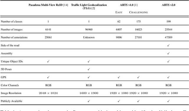
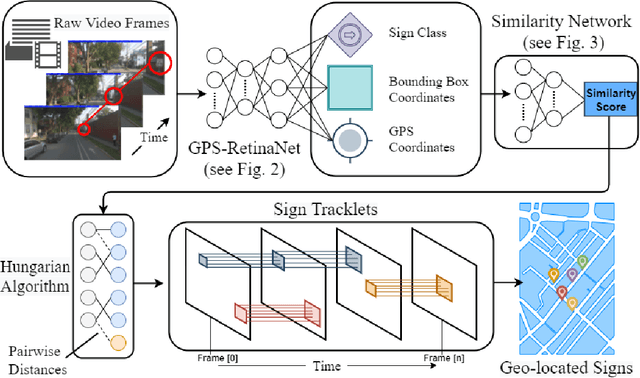
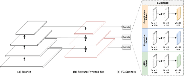
Abstract:Geo-localizing static objects from street images is challenging but also very important for road asset mapping and autonomous driving. In this paper we present a two-stage framework that detects and geolocalizes traffic signs from low frame rate street videos. Our proposed system uses a modified version of RetinaNet (GPS-RetinaNet), which predicts a positional offset for each sign relative to the camera, in addition to performing the standard classification and bounding box regression. Candidate sign detections from GPS-RetinaNet are condensed into geolocalized signs by our custom tracker, which consists of a learned metric network and a variant of the Hungarian Algorithm. Our metric network estimates the similarity between pairs of detections, then the Hungarian Algorithm matches detections across images using the similarity scores provided by the metric network. Our models were trained using an updated version of the ARTS dataset, which contains 25,544 images and 47.589 sign annotations ~\cite{arts}. The proposed dataset covers a diverse set of environments gathered from a broad selection of roads. Each annotaiton contains a sign class label, its geospatial location, an assembly label, a side of road indicator, and unique identifiers that aid in the evaluation. This dataset will support future progress in the field, and the proposed system demonstrates how to take advantage of some of the unique characteristics of a realistic geolocalization dataset.
 Add to Chrome
 Add to Firefox
 Add to Edge