Olac Fuentes
Towards Precision Characterization of Communication Disorders using Models of Perceived Pragmatic Similarity
Sep 13, 2024


Abstract:The diagnosis and treatment of individuals with communication disorders offers many opportunities for the application of speech technology, but research so far has not adequately considered: the diversity of conditions, the role of pragmatic deficits, and the challenges of limited data. This paper explores how a general-purpose model of perceived pragmatic similarity may overcome these limitations. It explains how it might support several use cases for clinicians and clients, and presents evidence that a simple model can provide value, and in particular can capture utterance aspects that are relevant to diagnoses of autism and specific language impairment.
Which Prosodic Features Matter Most for Pragmatics?
Aug 23, 2024Abstract:We investigate which prosodic features matter most in conveying prosodic functions. We use the problem of predicting human perceptions of pragmatic similarity among utterance pairs to evaluate the utility of prosodic features of different types. We find, for example, that duration-related features are more important than pitch-related features, and that utterance-initial features are more important than utterance-final features. Further, failure analysis indicates that modeling using pitch features only often fails to handle important pragmatic functions, and suggests that several generally-neglected acoustic and prosodic features are pragmatically significant, including nasality and vibrato. These findings can guide future basic research in prosody, and suggest how to improve speech synthesis evaluation, among other applications.
Boundary Aware U-Net for Glacier Segmentation
Jan 26, 2023


Abstract:Large-scale study of glaciers improves our understanding of global glacier change and is imperative for monitoring the ecological environment, preventing disasters, and studying the effects of global climate change. Glaciers in the Hindu Kush Himalaya (HKH) are particularly interesting as the HKH is one of the world's most sensitive regions for climate change. In this work, we: (1) propose a modified version of the U-Net for large-scale, spatially non-overlapping, clean glacial ice, and debris-covered glacial ice segmentation; (2) introduce a novel self-learning boundary-aware loss to improve debris-covered glacial ice segmentation performance; and (3) propose a feature-wise saliency score to understand the contribution of each feature in the multispectral Landsat 7 imagery for glacier mapping. Our results show that the debris-covered glacial ice segmentation model trained using self-learning boundary-aware loss outperformed the model trained using dice loss. Furthermore, we conclude that red, shortwave infrared, and near-infrared bands have the highest contribution toward debris-covered glacial ice segmentation from Landsat 7 images.
Local Context Normalization: Revisiting Local Normalization
Dec 13, 2019


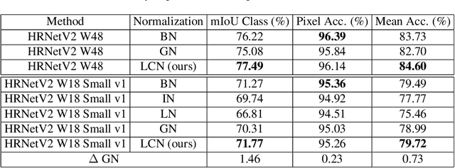
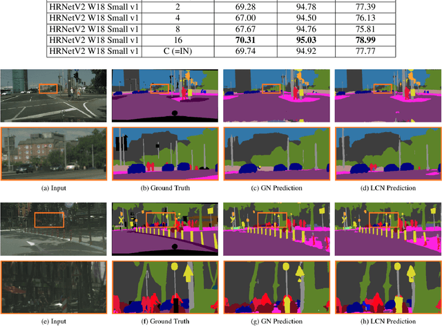
Abstract:Normalization layers have been shown to improve convergence in deep neural networks. In many vision applications the local spatial context of the features is important, but most common normalization schemes includingGroup Normalization (GN), Instance Normalization (IN), and Layer Normalization (LN) normalize over the entire spatial dimension of a feature. This can wash out important signals and degrade performance. For example, in applications that use satellite imagery, input images can be arbitrarily large; consequently, it is nonsensical to normalize over the entire area. Positional Normalization (PN), on the other hand, only normalizes over a single spatial position at a time. A natural compromise is to normalize features by local context, while also taking into account group level information. In this paper, we propose Local Context Normalization (LCN): a normalization layer where every feature is normalized based on a window around it and the filters in its group. We propose an algorithmic solution to make LCN efficient for arbitrary window sizes, even if every point in the image has a unique window. LCN outperforms its Batch Normalization (BN), GN, IN, and LN counterparts for object detection, semantic segmentation, and instance segmentation applications in several benchmark datasets, while keeping performance independent of the batch size and facilitating transfer learning.
3D Terrain Segmentation in the SWIR Spectrum
Oct 27, 2018


Abstract:We focus on the automatic 3D terrain segmentation problem using hyperspectral shortwave IR (HS-SWIR) imagery and 3D Digital Elevation Models (DEM). The datasets were independently collected, and metadata for the HS-SWIR dataset are unavailable. We explore an overall slope of the SWIR spectrum that correlates with the presence of moisture in soil to propose a band ratio test to be used as a proxy for soil moisture content to distinguish two broad classes of objects: live vegetation from impermeable manmade surface. We show that image based localization techniques combined with the Optimal Randomized RANdom Sample Consensus (RANSAC) algorithm achieve precise spatial matches between HS-SWIR data of a portion of downtown Los Angeles (LA (USA)) and the Visible image of a geo-registered 3D DEM, covering a wider-area of LA. Our spectral-elevation rule based approach yields an overall accuracy of 97.7%, segmenting the object classes into buildings, houses, trees, grass, and roads/parking lots.
 Add to Chrome
 Add to Firefox
 Add to Edge