Maurice Günder
Model-agnostic Body Part Relevance Assessment for Pedestrian Detection
Nov 27, 2023


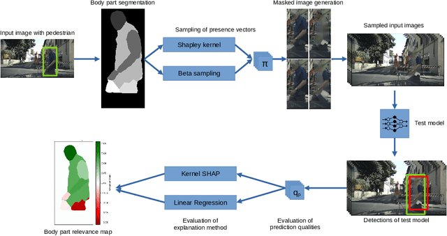
Abstract:Model-agnostic explanation methods for deep learning models are flexible regarding usability and availability. However, due to the fact that they can only manipulate input to see changes in output, they suffer from weak performance when used with complex model architectures. For models with large inputs as, for instance, in object detection, sampling-based methods like KernelSHAP are inefficient due to many computation-heavy forward passes through the model. In this work, we present a framework for using sampling-based explanation models in a computer vision context by body part relevance assessment for pedestrian detection. Furthermore, we introduce a novel sampling-based method similar to KernelSHAP that shows more robustness for lower sampling sizes and, thus, is more efficient for explainability analyses on large-scale datasets.
SugarViT -- Multi-objective Regression of UAV Images with Vision Transformers and Deep Label Distribution Learning Demonstrated on Disease Severity Prediction in Sugar Beet
Nov 07, 2023


Abstract:Remote sensing and artificial intelligence are pivotal technologies of precision agriculture nowadays. The efficient retrieval of large-scale field imagery combined with machine learning techniques shows success in various tasks like phenotyping, weeding, cropping, and disease control. This work will introduce a machine learning framework for automatized large-scale plant-specific trait annotation for the use case disease severity scoring for Cercospora Leaf Spot (CLS) in sugar beet. With concepts of Deep Label Distribution Learning (DLDL), special loss functions, and a tailored model architecture, we develop an efficient Vision Transformer based model for disease severity scoring called SugarViT. One novelty in this work is the combination of remote sensing data with environmental parameters of the experimental sites for disease severity prediction. Although the model is evaluated on this special use case, it is held as generic as possible to also be applicable to various image-based classification and regression tasks. With our framework, it is even possible to learn models on multi-objective problems as we show by a pretraining on environmental metadata.
Full Kullback-Leibler-Divergence Loss for Hyperparameter-free Label Distribution Learning
Sep 05, 2022


Abstract:The concept of Label Distribution Learning (LDL) is a technique to stabilize classification and regression problems with ambiguous and/or imbalanced labels. A prototypical use-case of LDL is human age estimation based on profile images. Regarding this regression problem, a so called Deep Label Distribution Learning (DLDL) method has been developed. The main idea is the joint regression of the label distribution and its expectation value. However, the original DLDL method uses loss components with different mathematical motivation and, thus, different scales, which is why the use of a hyperparameter becomes necessary. In this work, we introduce a loss function for DLDL whose components are completely defined by Kullback-Leibler (KL) divergences and, thus, are directly comparable to each other without the need of additional hyperparameters. It generalizes the concept of DLDL with regard to further use-cases, in particular for multi-dimensional or multi-scale distribution learning tasks.
Agricultural Plant Cataloging and Establishment of a Data Framework from UAV-based Crop Images by Computer Vision
Jan 11, 2022


Abstract:UAV-based image retrieval in modern agriculture enables gathering large amounts of spatially referenced crop image data. In large-scale experiments, however, UAV images suffer from containing a multitudinous amount of crops in a complex canopy architecture. Especially for the observation of temporal effects, this complicates the recognition of individual plants over several images and the extraction of relevant information tremendously. In this work, we present a hands-on workflow for the automatized temporal and spatial identification and individualization of crop images from UAVs abbreviated as "cataloging" based on comprehensible computer vision methods. We evaluate the workflow on two real-world datasets. One dataset is recorded for observation of Cercospora leaf spot - a fungal disease - in sugar beet over an entire growing cycle. The other one deals with harvest prediction of cauliflower plants. The plant catalog is utilized for the extraction of single plant images seen over multiple time points. This gathers large-scale spatio-temporal image dataset that in turn can be applied to train further machine learning models including various data layers. The presented approach improves analysis and interpretation of UAV data in agriculture significantly. By validation with some reference data, our method shows an accuracy that is similar to more complex deep learning-based recognition techniques. Our workflow is able to automatize plant cataloging and training image extraction, especially for large datasets.
 Add to Chrome
 Add to Firefox
 Add to Edge