Marta Gonzalez
A Causal Discovery Approach To Learn How Urban Form Shapes Sustainable Mobility Across Continents
Aug 31, 2023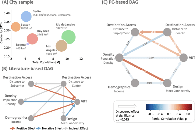

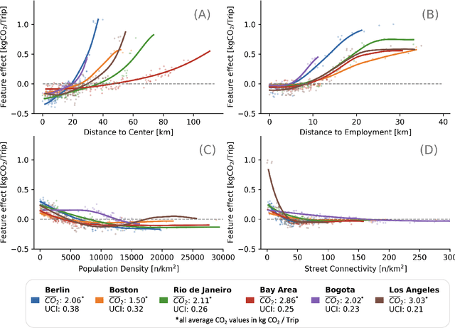

Abstract:Global sustainability requires low-carbon urban transport systems, shaped by adequate infrastructure, deployment of low-carbon transport modes and shifts in travel behavior. To adequately implement alterations in infrastructure, it's essential to grasp the location-specific cause-and-effect mechanisms that the constructed environment has on travel. Yet, current research falls short in representing causal relationships between the 6D urban form variables and travel, generalizing across different regions, and modeling urban form effects at high spatial resolution. Here, we address all three gaps by utilizing a causal discovery and an explainable machine learning framework to detect urban form effects on intra-city travel based on high-resolution mobility data of six cities across three continents. We show that both distance to city center, demographics and density indirectly affect other urban form features. By considering the causal relationships, we find that location-specific influences align across cities, yet vary in magnitude. In addition, the spread of the city and the coverage of jobs across the city are the strongest determinants of travel-related emissions, highlighting the benefits of compact development and associated benefits. Differences in urban form effects across the cities call for a more holistic definition of 6D measures. Our work is a starting point for location-specific analysis of urban form effects on mobility behavior using causal discovery approaches, which is highly relevant for city planners and municipalities across continents.
Exploring the Role of Explainability in AI-Assisted Embryo Selection
Aug 01, 2023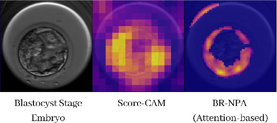
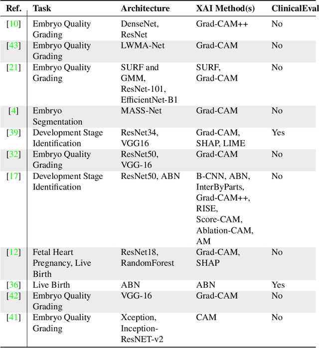
Abstract:In Vitro Fertilization is among the most widespread treatments for infertility. One of its main challenges is the evaluation and selection of embryo for implantation, a process with large inter- and intra-clinician variability. Deep learning based methods are gaining attention, but their opaque nature compromises their acceptance in the clinical context, where transparency in the decision making is key. In this paper we analyze the current work in the explainability of AI-assisted embryo analysis models, identifying the limitations. We also discuss how these models could be integrated in the clinical context as decision support systems, considering the needs of clinicians and patients. Finally, we propose guidelines for the sake of increasing interpretability and trustworthiness, pushing this technology forward towards established clinical practice.
Streetify: Using Street View Imagery And Deep Learning For Urban Streets Development
Nov 18, 2019
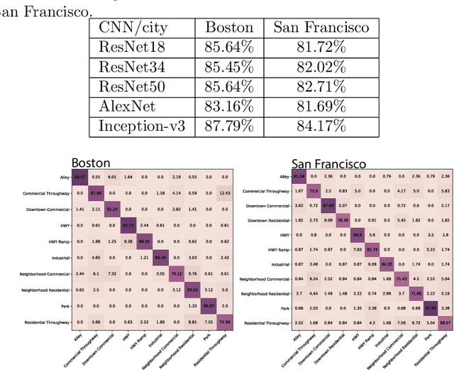
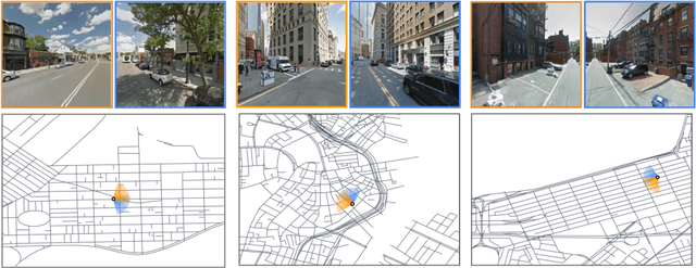
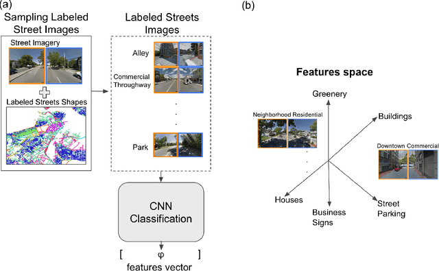
Abstract:The classification of streets on road networks has been focused on the vehicular transportational features of streets such as arterials, major roads, minor roads and so forth based on their transportational use. City authorities on the other hand have been shifting to more urban inclusive planning of streets, encompassing the side use of a street combined with the transportational features of a street. In such classification schemes, streets are labeled for example as commercial throughway, residential neighborhood, park etc. This modern approach to urban planning has been adopted by major cities such as the city of San Francisco, the states of Florida and Pennsylvania among many others. Currently, the process of labeling streets according to their contexts is manual and hence is tedious and time consuming. In this paper, we propose an approach to collect and label imagery data then deploy advancements in computer vision towards modern urban planning. We collect and label street imagery then train deep convolutional neural networks (CNN) to perform the classification of street context. We show that CNN models can perform well achieving accuracies in the 81% to 87%, we then visualize samples from the embedding space of streets using the t-SNE method and apply class activation mapping methods to interpret the features in street imagery contributing to output classification from a model.
Spatial sensitivity analysis for urban land use prediction with physics-constrained conditional generative adversarial networks
Jul 22, 2019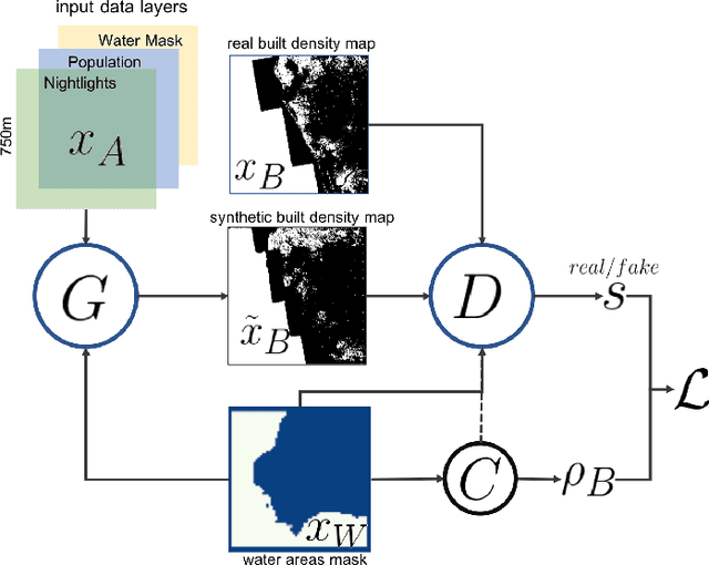
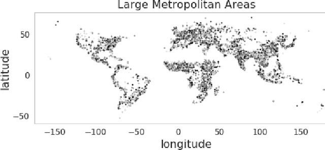
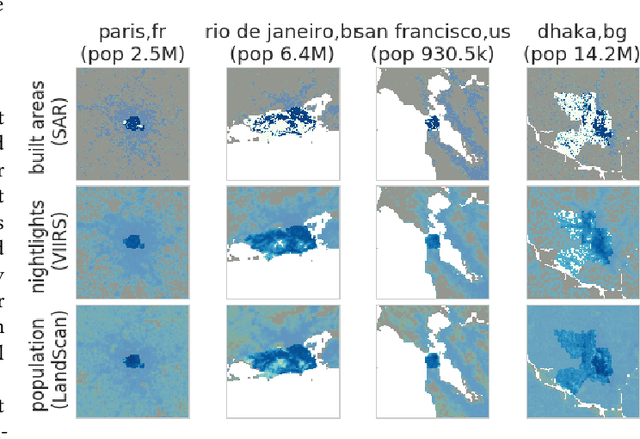
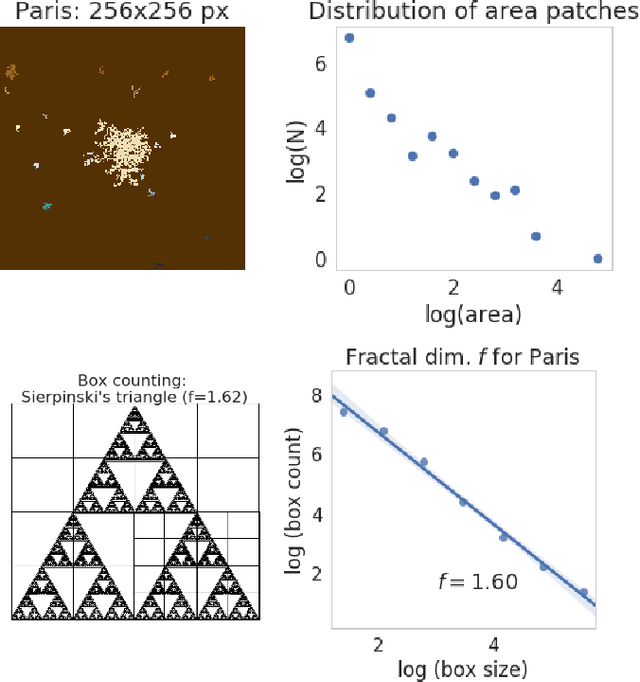
Abstract:Accurately forecasting urban development and its environmental and climate impacts critically depends on realistic models of the spatial structure of the built environment, and of its dependence on key factors such as population and economic development. Scenario simulation and sensitivity analysis, i.e., predicting how changes in underlying factors at a given location affect urbanization outcomes at other locations, is currently not achievable at a large scale with traditional urban growth models, which are either too simplistic, or depend on detailed locally-collected socioeconomic data that is not available in most places. Here we develop a framework to estimate, purely from globally-available remote-sensing data and without parametric assumptions, the spatial sensitivity of the (\textit{static}) rate of change of urban sprawl to key macroeconomic development indicators. We formulate this spatial regression problem as an image-to-image translation task using conditional generative adversarial networks (GANs), where the gradients necessary for comparative static analysis are provided by the backpropagation algorithm used to train the model. This framework allows to naturally incorporate physical constraints, e.g., the inability to build over water bodies. To validate the spatial structure of model-generated built environment distributions, we use spatial statistics commonly used in urban form analysis. We apply our method to a novel dataset comprising of layers on the built environment, nightlighs measurements (a proxy for economic development and energy use), and population density for the world's most populous 15,000 cities.
Modeling urbanization patterns with generative adversarial networks
Jan 08, 2018


Abstract:In this study we propose a new method to simulate hyper-realistic urban patterns using Generative Adversarial Networks trained with a global urban land-use inventory. We generated a synthetic urban "universe" that qualitatively reproduces the complex spatial organization observed in global urban patterns, while being able to quantitatively recover certain key high-level urban spatial metrics.
Using convolutional networks and satellite imagery to identify patterns in urban environments at a large scale
Sep 13, 2017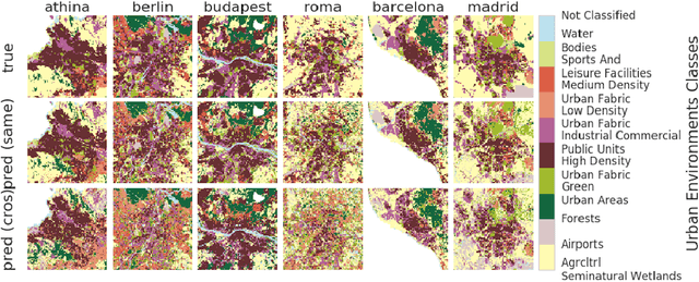
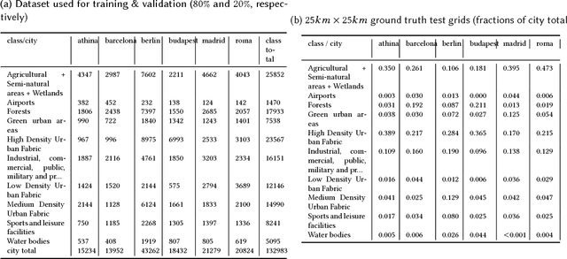
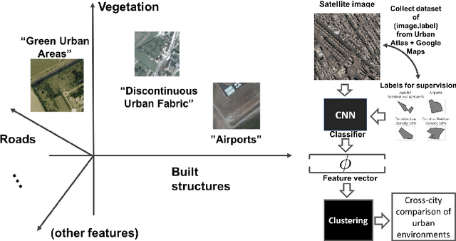

Abstract:Urban planning applications (energy audits, investment, etc.) require an understanding of built infrastructure and its environment, i.e., both low-level, physical features (amount of vegetation, building area and geometry etc.), as well as higher-level concepts such as land use classes (which encode expert understanding of socio-economic end uses). This kind of data is expensive and labor-intensive to obtain, which limits its availability (particularly in developing countries). We analyze patterns in land use in urban neighborhoods using large-scale satellite imagery data (which is available worldwide from third-party providers) and state-of-the-art computer vision techniques based on deep convolutional neural networks. For supervision, given the limited availability of standard benchmarks for remote-sensing data, we obtain ground truth land use class labels carefully sampled from open-source surveys, in particular the Urban Atlas land classification dataset of $20$ land use classes across $~300$ European cities. We use this data to train and compare deep architectures which have recently shown good performance on standard computer vision tasks (image classification and segmentation), including on geospatial data. Furthermore, we show that the deep representations extracted from satellite imagery of urban environments can be used to compare neighborhoods across several cities. We make our dataset available for other machine learning researchers to use for remote-sensing applications.
 Add to Chrome
 Add to Firefox
 Add to Edge