Marisa Hughes
Difference Learning for Air Quality Forecasting Transport Emulation
Feb 22, 2024


Abstract:Human health is negatively impacted by poor air quality including increased risk for respiratory and cardiovascular disease. Due to a recent increase in extreme air quality events, both globally and locally in the United States, finer resolution air quality forecasting guidance is needed to effectively adapt to these events. The National Oceanic and Atmospheric Administration provides air quality forecasting guidance for the Continental United States. Their air quality forecasting model is based on a 15 km spatial resolution; however, the goal is to reach a three km spatial resolution. This is currently not feasible due in part to prohibitive computational requirements for modeling the transport of chemical species. In this work, we describe a deep learning transport emulator that is able to reduce computations while maintaining skill comparable with the existing numerical model. We show how this method maintains skill in the presence of extreme air quality events, making it a potential candidate for operational use. We also explore evaluating how well this model maintains the physical properties of the modeled transport for a given set of species.
A Generative Adversarial Network for Climate Tipping Point Discovery (TIP-GAN)
Feb 16, 2023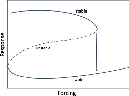

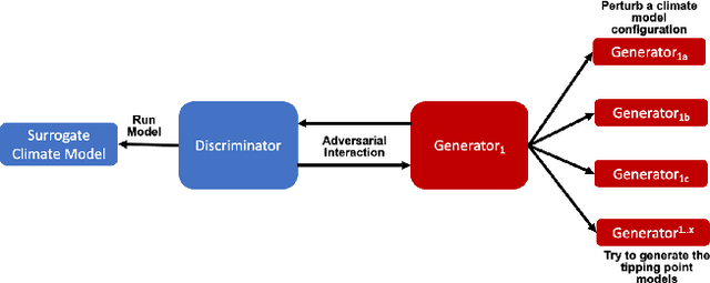

Abstract:We propose a new Tipping Point Generative Adversarial Network (TIP-GAN) for better characterizing potential climate tipping points in Earth system models. We describe an adversarial game to explore the parameter space of these models, detect upcoming tipping points, and discover the drivers of tipping points. In this setup, a set of generators learn to construct model configurations that will invoke a climate tipping point. The discriminator learns to identify which generators are generating each model configuration and whether a given configuration will lead to a tipping point. The discriminator is trained using an oracle (a surrogate climate model) to test if a generated model configuration leads to a tipping point or not. We demonstrate the application of this GAN to invoke the collapse of the Atlantic Meridional Overturning Circulation (AMOC). We share experimental results of modifying the loss functions and the number of generators to exploit the area of uncertainty in model state space near a climate tipping point. In addition, we show that our trained discriminator can predict AMOC collapse with a high degree of accuracy without the use of the oracle. This approach could generalize to other tipping points, and could augment climate modeling research by directing users interested in studying tipping points to parameter sets likely to induce said tipping points in their computationally intensive climate models.
Using Artificial Intelligence to aid Scientific Discovery of Climate Tipping Points
Feb 14, 2023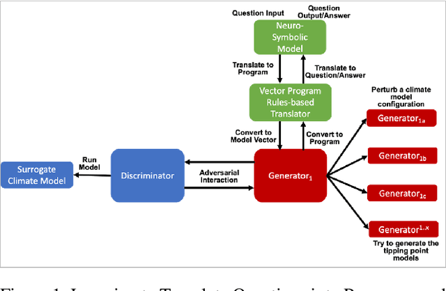

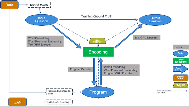

Abstract:We propose a hybrid Artificial Intelligence (AI) climate modeling approach that enables climate modelers in scientific discovery using a climate-targeted simulation methodology based on a novel combination of deep neural networks and mathematical methods for modeling dynamical systems. The simulations are grounded by a neuro-symbolic language that both enables question answering of what is learned by the AI methods and provides a means of explainability. We describe how this methodology can be applied to the discovery of climate tipping points and, in particular, the collapse of the Atlantic Meridional Overturning Circulation (AMOC). We show how this methodology is able to predict AMOC collapse with a high degree of accuracy using a surrogate climate model for ocean interaction. We also show preliminary results of neuro-symbolic method performance when translating between natural language questions and symbolically learned representations. Our AI methodology shows promising early results, potentially enabling faster climate tipping point related research that would otherwise be computationally infeasible.
Towards Indirect Top-Down Road Transport Emissions Estimation
Mar 16, 2021

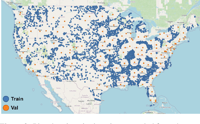

Abstract:Road transportation is one of the largest sectors of greenhouse gas (GHG) emissions affecting climate change. Tackling climate change as a global community will require new capabilities to measure and inventory road transport emissions. However, the large scale and distributed nature of vehicle emissions make this sector especially challenging for existing inventory methods. In this work, we develop machine learning models that use satellite imagery to perform indirect top-down estimation of road transport emissions. Our initial experiments focus on the United States, where a bottom-up inventory was available for training our models. We achieved a mean absolute error (MAE) of 39.5 kg CO$_{2}$ of annual road transport emissions, calculated on a pixel-by-pixel (100 m$^{2}$) basis in Sentinel-2 imagery. We also discuss key model assumptions and challenges that need to be addressed to develop models capable of generalizing to global geography. We believe this work is the first published approach for automated indirect top-down estimation of road transport sector emissions using visual imagery and represents a critical step towards scalable, global, near-real-time road transportation emissions inventories that are measured both independently and objectively.
 Add to Chrome
 Add to Firefox
 Add to Edge