Lucia Gordon
Dynamic Framework for Collaborative Learning: Leveraging Advanced LLM with Adaptive Feedback Mechanisms
Jan 29, 2026Abstract:This paper presents a framework for integrating LLM into collaborative learning platforms to enhance student engagement, critical thinking, and inclusivity. The framework employs advanced LLMs as dynamic moderators to facilitate real-time discussions and adapt to learners' evolving needs, ensuring diverse and inclusive educational experiences. Key innovations include robust feedback mechanisms that refine AI moderation, promote reflective learning, and balance participation among users. The system's modular architecture featuring ReactJS for the frontend, Flask for backend operations, and efficient question retrieval supports personalized and engaging interactions through dynamic adjustments to prompts and discussion flows. Testing demonstrates that the framework significantly improves student collaboration, fosters deeper comprehension, and scales effectively across various subjects and user groups. By addressing limitations in static moderation and personalization in existing systems, this work establishes a strong foundation for next-generation AI-driven educational tools, advancing equitable and impactful learning outcomes.
Contrasting local and global modeling with machine learning and satellite data: A case study estimating tree canopy height in African savannas
Nov 21, 2024Abstract:While advances in machine learning with satellite imagery (SatML) are facilitating environmental monitoring at a global scale, developing SatML models that are accurate and useful for local regions remains critical to understanding and acting on an ever-changing planet. As increasing attention and resources are being devoted to training SatML models with global data, it is important to understand when improvements in global models will make it easier to train or fine-tune models that are accurate in specific regions. To explore this question, we contrast local and global training paradigms for SatML through a case study of tree canopy height (TCH) mapping in the Karingani Game Reserve, Mozambique. We find that recent advances in global TCH mapping do not necessarily translate to better local modeling abilities in our study region. Specifically, small models trained only with locally-collected data outperform published global TCH maps, and even outperform globally pretrained models that we fine-tune using local data. Analyzing these results further, we identify specific points of conflict and synergy between local and global modeling paradigms that can inform future research toward aligning local and global performance objectives in geospatial machine learning.
Multimodal Fusion Strategies for Mapping Biophysical Landscape Features
Oct 07, 2024


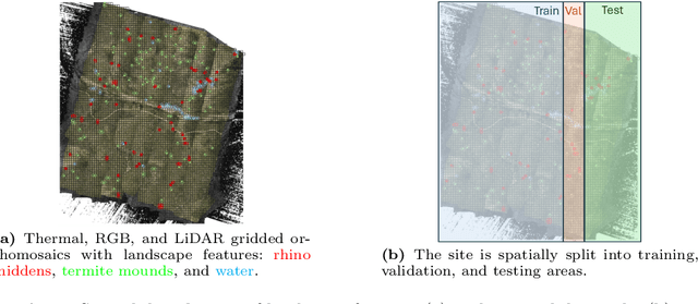
Abstract:Multimodal aerial data are used to monitor natural systems, and machine learning can significantly accelerate the classification of landscape features within such imagery to benefit ecology and conservation. It remains under-explored, however, how these multiple modalities ought to be fused in a deep learning model. As a step towards filling this gap, we study three strategies (Early fusion, Late fusion, and Mixture of Experts) for fusing thermal, RGB, and LiDAR imagery using a dataset of spatially-aligned orthomosaics in these three modalities. In particular, we aim to map three ecologically-relevant biophysical landscape features in African savanna ecosystems: rhino middens, termite mounds, and water. The three fusion strategies differ in whether the modalities are fused early or late, and if late, whether the model learns fixed weights per modality for each class or generates weights for each class adaptively, based on the input. Overall, the three methods have similar macro-averaged performance with Late fusion achieving an AUC of 0.698, but their per-class performance varies strongly, with Early fusion achieving the best recall for middens and water and Mixture of Experts achieving the best recall for mounds.
Find Rhinos without Finding Rhinos: Active Learning with Multimodal Imagery of South African Rhino Habitats
Sep 26, 2024


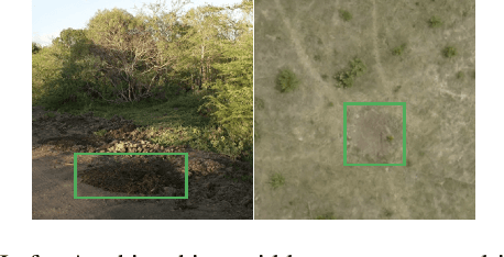
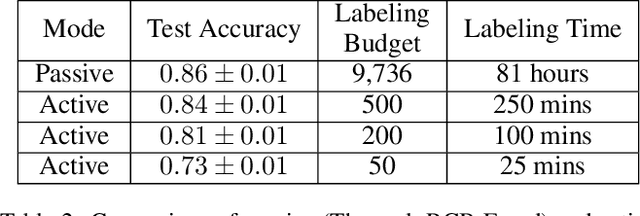
Abstract:Much of Earth's charismatic megafauna is endangered by human activities, particularly the rhino, which is at risk of extinction due to the poaching crisis in Africa. Monitoring rhinos' movement is crucial to their protection but has unfortunately proven difficult because rhinos are elusive. Therefore, instead of tracking rhinos, we propose the novel approach of mapping communal defecation sites, called middens, which give information about rhinos' spatial behavior valuable to anti-poaching, management, and reintroduction efforts. This paper provides the first-ever mapping of rhino midden locations by building classifiers to detect them using remotely sensed thermal, RGB, and LiDAR imagery in passive and active learning settings. As existing active learning methods perform poorly due to the extreme class imbalance in our dataset, we design MultimodAL, an active learning system employing a ranking technique and multimodality to achieve competitive performance with passive learning models with 94% fewer labels. Our methods could therefore save over 76 hours in labeling time when used on a similarly-sized dataset. Unexpectedly, our midden map reveals that rhino middens are not randomly distributed throughout the landscape; rather, they are clustered. Consequently, rangers should be targeted at areas with high midden densities to strengthen anti-poaching efforts, in line with UN Target 15.7.
* 9 pages, 9 figures, IJCAI 2023 Special Track on AI for Good
Combining Diverse Information for Coordinated Action: Stochastic Bandit Algorithms for Heterogeneous Agents
Aug 06, 2024


Abstract:Stochastic multi-agent multi-armed bandits typically assume that the rewards from each arm follow a fixed distribution, regardless of which agent pulls the arm. However, in many real-world settings, rewards can depend on the sensitivity of each agent to their environment. In medical screening, disease detection rates can vary by test type; in preference matching, rewards can depend on user preferences; and in environmental sensing, observation quality can vary across sensors. Since past work does not specify how to allocate agents of heterogeneous but known sensitivity of these types in a stochastic bandit setting, we introduce a UCB-style algorithm, Min-Width, which aggregates information from diverse agents. In doing so, we address the joint challenges of (i) aggregating the rewards, which follow different distributions for each agent-arm pair, and (ii) coordinating the assignments of agents to arms. Min-Width facilitates efficient collaboration among heterogeneous agents, exploiting the known structure in the agents' reward functions to weight their rewards accordingly. We analyze the regret of Min-Width and conduct pseudo-synthetic and fully synthetic experiments to study the performance of different levels of information sharing. Our results confirm that the gains to modeling agent heterogeneity tend to be greater when the sensitivities are more varied across agents, while combining more information does not always improve performance.
 Add to Chrome
 Add to Firefox
 Add to Edge