Catherine Ressijac
Multimodal Fusion Strategies for Mapping Biophysical Landscape Features
Oct 07, 2024


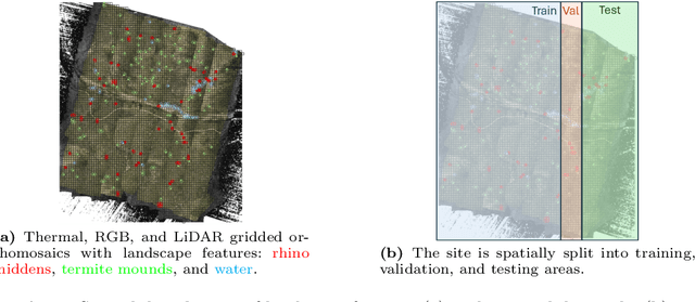
Abstract:Multimodal aerial data are used to monitor natural systems, and machine learning can significantly accelerate the classification of landscape features within such imagery to benefit ecology and conservation. It remains under-explored, however, how these multiple modalities ought to be fused in a deep learning model. As a step towards filling this gap, we study three strategies (Early fusion, Late fusion, and Mixture of Experts) for fusing thermal, RGB, and LiDAR imagery using a dataset of spatially-aligned orthomosaics in these three modalities. In particular, we aim to map three ecologically-relevant biophysical landscape features in African savanna ecosystems: rhino middens, termite mounds, and water. The three fusion strategies differ in whether the modalities are fused early or late, and if late, whether the model learns fixed weights per modality for each class or generates weights for each class adaptively, based on the input. Overall, the three methods have similar macro-averaged performance with Late fusion achieving an AUC of 0.698, but their per-class performance varies strongly, with Early fusion achieving the best recall for middens and water and Mixture of Experts achieving the best recall for mounds.
Find Rhinos without Finding Rhinos: Active Learning with Multimodal Imagery of South African Rhino Habitats
Sep 26, 2024


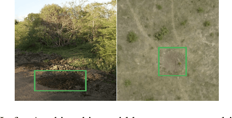
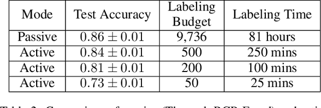
Abstract:Much of Earth's charismatic megafauna is endangered by human activities, particularly the rhino, which is at risk of extinction due to the poaching crisis in Africa. Monitoring rhinos' movement is crucial to their protection but has unfortunately proven difficult because rhinos are elusive. Therefore, instead of tracking rhinos, we propose the novel approach of mapping communal defecation sites, called middens, which give information about rhinos' spatial behavior valuable to anti-poaching, management, and reintroduction efforts. This paper provides the first-ever mapping of rhino midden locations by building classifiers to detect them using remotely sensed thermal, RGB, and LiDAR imagery in passive and active learning settings. As existing active learning methods perform poorly due to the extreme class imbalance in our dataset, we design MultimodAL, an active learning system employing a ranking technique and multimodality to achieve competitive performance with passive learning models with 94% fewer labels. Our methods could therefore save over 76 hours in labeling time when used on a similarly-sized dataset. Unexpectedly, our midden map reveals that rhino middens are not randomly distributed throughout the landscape; rather, they are clustered. Consequently, rangers should be targeted at areas with high midden densities to strengthen anti-poaching efforts, in line with UN Target 15.7.
* 9 pages, 9 figures, IJCAI 2023 Special Track on AI for Good
 Add to Chrome
 Add to Firefox
 Add to Edge