 Add to Chrome
 Add to Firefox
 Add to Edge
Towards a Barrier-free GeoQA Portal: Natural Language Interaction with Geospatial Data Using Multi-Agent LLMs and Semantic Search
Mar 18, 2025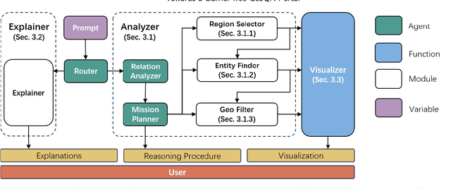
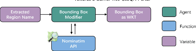
A Barrier-Free GeoQA Portal: Enhancing Geospatial Data Accessibility with a Multi-Agent LLM Framework Geoportals are vital for accessing and analyzing geospatial data, promoting open spatial data sharing and online geo-information management. Designed with GIS-like interaction and layered visualization, they often challenge non-expert users with complex functionalities and overlapping layers that obscure spatial relationships. We propose a GeoQA Portal using a multi-agent Large Language Model framework for seamless natural language interaction with geospatial data. Complex queries are broken into subtasks handled by specialized agents, retrieving relevant geographic data efficiently. Task plans are shown to users, boosting transparency. The portal supports default and custom data inputs for flexibility. Semantic search via word vector similarity aids data retrieval despite imperfect terms. Case studies, evaluations, and user tests confirm its effectiveness for non-experts, bridging GIS complexity and public access, and offering an intuitive solution for future geoportals.
Integrating 3D City Data through Knowledge Graphs
Oct 17, 2023CityGML is a widely adopted standard by the Open Geospatial Consortium (OGC) for representing and exchanging 3D city models. The representation of semantic and topological properties in CityGML makes it possible to query such 3D city data to perform analysis in various applications, e.g., security management and emergency response, energy consumption and estimation, and occupancy measurement. However, the potential of querying CityGML data has not been fully exploited. The official GML/XML encoding of CityGML is only intended as an exchange format but is not suitable for query answering. The most common way of dealing with CityGML data is to store them in the 3DCityDB system as relational tables and then query them with the standard SQL query language. Nevertheless, for end users, it remains a challenging task to formulate queries over 3DCityDB directly for their ad-hoc analytical tasks, because there is a gap between the conceptual semantics of CityGML and the relational schema adopted in 3DCityDB. In fact, the semantics of CityGML itself can be modeled as a suitable ontology. The technology of Knowledge Graphs (KGs), where an ontology is at the core, is a good solution to bridge such a gap. Moreover, embracing KGs makes it easier to integrate with other spatial data sources, e.g., OpenStreetMap and existing (Geo)KGs (e.g., Wikidata, DBPedia, and GeoNames), and to perform queries combining information from multiple data sources. In this work, we describe a CityGML KG framework to populate the concepts in the CityGML ontology using declarative mappings to 3DCityDB, thus exposing the CityGML data therein as a KG. To demonstrate the feasibility of our approach, we use CityGML data from the city of Munich as test data and integrate OpenStreeMap data in the same area.