Jiangyi Fang
Effective Online 3D Bin Packing with Lookahead Parcels Using Monte Carlo Tree Search
Jan 06, 2026Abstract:Online 3D Bin Packing (3D-BP) with robotic arms is crucial for reducing transportation and labor costs in modern logistics. While Deep Reinforcement Learning (DRL) has shown strong performance, it often fails to adapt to real-world short-term distribution shifts, which arise as different batches of goods arrive sequentially, causing performance drops. We argue that the short-term lookahead information available in modern logistics systems is key to mitigating this issue, especially during distribution shifts. We formulate online 3D-BP with lookahead parcels as a Model Predictive Control (MPC) problem and adapt the Monte Carlo Tree Search (MCTS) framework to solve it. Our framework employs a dynamic exploration prior that automatically balances a learned RL policy and a robust random policy based on the lookahead characteristics. Additionally, we design an auxiliary reward to penalize long-term spatial waste from individual placements. Extensive experiments on real-world datasets show that our method consistently outperforms state-of-the-art baselines, achieving over 10\% gains under distributional shifts, 4\% average improvement in online deployment, and up to more than 8\% in the best case--demonstrating the effectiveness of our framework.
STContext: A Multifaceted Dataset for Developing Context-aware Spatio-temporal Crowd Mobility Prediction Models
Jan 07, 2025Abstract:In smart cities, context-aware spatio-temporal crowd flow prediction (STCFP) models leverage contextual features (e.g., weather) to identify unusual crowd mobility patterns and enhance prediction accuracy. However, the best practice for incorporating contextual features remains unclear due to inconsistent usage of contextual features in different papers. Developing a multifaceted dataset with rich types of contextual features and STCFP scenarios is crucial for establishing a principled context modeling paradigm. Existing open crowd flow datasets lack an adequate range of contextual features, which poses an urgent requirement to build a multifaceted dataset to fill these research gaps. To this end, we create STContext, a multifaceted dataset for developing context-aware STCFP models. Specifically, STContext provides nine spatio-temporal datasets across five STCFP scenarios and includes ten contextual features, including weather, air quality index, holidays, points of interest, road networks, etc. Besides, we propose a unified workflow for incorporating contextual features into deep STCFP methods, with steps including feature transformation, dependency modeling, representation fusion, and training strategies. Through extensive experiments, we have obtained several useful guidelines for effective context modeling and insights for future research. The STContext is open-sourced at https://github.com/Liyue-Chen/STContext.
A Unified Model for Spatio-Temporal Prediction Queries with Arbitrary Modifiable Areal Units
Mar 10, 2024


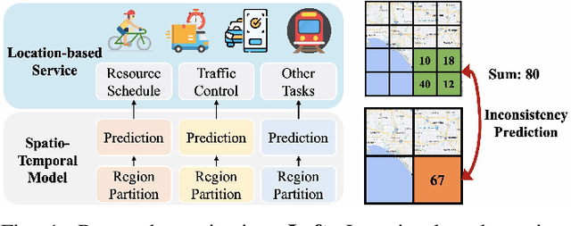
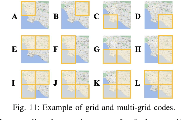
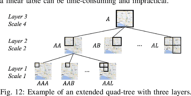
Abstract:Spatio-Temporal (ST) prediction is crucial for making informed decisions in urban location-based applications like ride-sharing. However, existing ST models often require region partition as a prerequisite, resulting in two main pitfalls. Firstly, location-based services necessitate ad-hoc regions for various purposes, requiring multiple ST models with varying scales and zones, which can be costly to support. Secondly, different ST models may produce conflicting outputs, resulting in confusing predictions. In this paper, we propose One4All-ST, a framework that can conduct ST prediction for arbitrary modifiable areal units using only one model. To reduce the cost of getting multi-scale predictions, we design an ST network with hierarchical spatial modeling and scale normalization modules to efficiently and equally learn multi-scale representations. To address prediction inconsistencies across scales, we propose a dynamic programming scheme to solve the formulated optimal combination problem, minimizing predicted error through theoretical analysis. Besides, we suggest using an extended quad-tree to index the optimal combinations for quick response to arbitrary modifiable areal units in practical online scenarios. Extensive experiments on two real-world datasets verify the efficiency and effectiveness of One4All-ST in ST prediction for arbitrary modifiable areal units. The source codes and data of this work are available at https://github.com/uctb/One4All-ST.
A Data-driven Region Generation Framework for Spatiotemporal Transportation Service Management
Jun 05, 2023Abstract:MAUP (modifiable areal unit problem) is a fundamental problem for spatial data management and analysis. As an instantiation of MAUP in online transportation platforms, region generation (i.e., specifying the areal unit for service operations) is the first and vital step for supporting spatiotemporal transportation services such as ride-sharing and freight transport. Most existing region generation methods are manually specified (e.g., fixed-size grids), suffering from poor spatial semantic meaning and inflexibility to meet service operation requirements. In this paper, we propose RegionGen, a data-driven region generation framework that can specify regions with key characteristics (e.g., good spatial semantic meaning and predictability) by modeling region generation as a multi-objective optimization problem. First, to obtain good spatial semantic meaning, RegionGen segments the whole city into atomic spatial elements based on road networks and obstacles (e.g., rivers). Then, it clusters the atomic spatial elements into regions by maximizing various operation characteristics, which is formulated as a multi-objective optimization problem. For this optimization problem, we propose a multi-objective co-optimization algorithm. Extensive experiments verify that RegionGen can generate more suitable regions than traditional methods for spatiotemporal service management.
 Add to Chrome
 Add to Firefox
 Add to Edge