 Add to Chrome
 Add to Firefox
 Add to Edge
TransitReID: Transit OD Data Collection with Occlusion-Resistant Dynamic Passenger Re-Identification
Apr 15, 2025


Transit Origin-Destination (OD) data are essential for transit planning, particularly in route optimization and demand-responsive paratransit systems. Traditional methods, such as manual surveys, are costly and inefficient, while Bluetooth and WiFi-based approaches require passengers to carry specific devices, limiting data coverage. On the other hand, most transit vehicles are equipped with onboard cameras for surveillance, offering an opportunity to repurpose them for edge-based OD data collection through visual person re-identification (ReID). However, such approaches face significant challenges, including severe occlusion and viewpoint variations in transit environments, which greatly reduce matching accuracy and hinder their adoption. Moreover, designing effective algorithms that can operate efficiently on edge devices remains an open challenge. To address these challenges, we propose TransitReID, a novel framework for individual-level transit OD data collection. TransitReID consists of two key components: (1) An occlusion-robust ReID algorithm featuring a variational autoencoder guided region-attention mechanism that adaptively focuses on visible body regions through reconstruction loss-optimized weight allocation; and (2) a Hierarchical Storage and Dynamic Matching (HSDM) mechanism specifically designed for efficient and robust transit OD matching which balances storage, speed, and accuracy. Additionally, a multi-threaded design supports near real-time operation on edge devices, which also ensuring privacy protection. We also introduce a ReID dataset tailored for complex bus environments to address the lack of relevant training data. Experimental results demonstrate that TransitReID achieves state-of-the-art performance in ReID tasks, with an accuracy of approximately 90\% in bus route simulations.
Arriving on time: estimating travel time distributions on large-scale road networks
Feb 26, 2013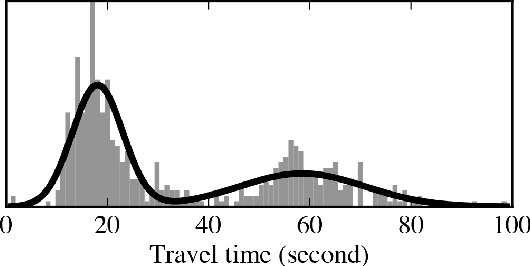
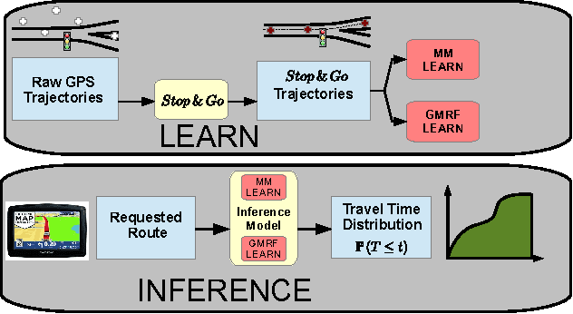
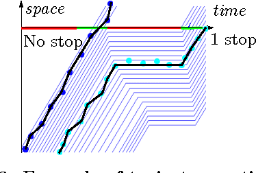
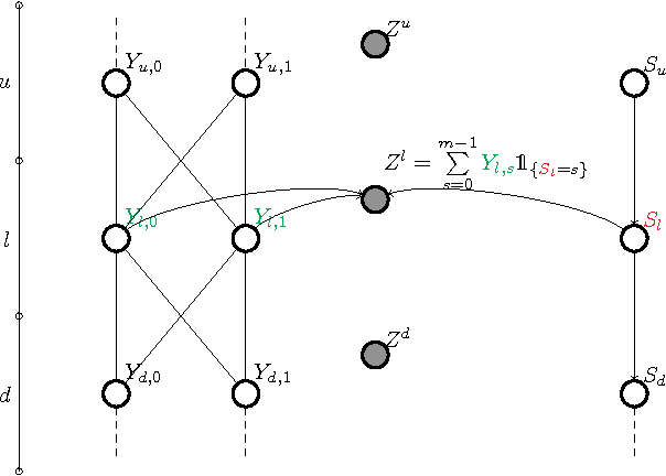
Most optimal routing problems focus on minimizing travel time or distance traveled. Oftentimes, a more useful objective is to maximize the probability of on-time arrival, which requires statistical distributions of travel times, rather than just mean values. We propose a method to estimate travel time distributions on large-scale road networks, using probe vehicle data collected from GPS. We present a framework that works with large input of data, and scales linearly with the size of the network. Leveraging the planar topology of the graph, the method computes efficiently the time correlations between neighboring streets. First, raw probe vehicle traces are compressed into pairs of travel times and number of stops for each traversed road segment using a `stop-and-go' algorithm developed for this work. The compressed data is then used as input for training a path travel time model, which couples a Markov model along with a Gaussian Markov random field. Finally, scalable inference algorithms are developed for obtaining path travel time distributions from the composite MM-GMRF model. We illustrate the accuracy and scalability of our model on a 505,000 road link network spanning the San Francisco Bay Area.