 Add to Chrome
 Add to Firefox
 Add to Edge
Democratizing planetary-scale analysis: An ultra-lightweight Earth embedding database for accurate and flexible global land monitoring
Jan 16, 2026The rapid evolution of satellite-borne Earth Observation (EO) systems has revolutionized terrestrial monitoring, yielding petabyte-scale archives. However, the immense computational and storage requirements for global-scale analysis often preclude widespread use, hindering planetary-scale studies. To address these barriers, we present Embedded Seamless Data (ESD), an ultra-lightweight, 30-m global Earth embedding database spanning the 25-year period from 2000 to 2024. By transforming high-dimensional, multi-sensor observations from the Landsat series (5, 7, 8, and 9) and MODIS Terra into information-dense, quantized latent vectors, ESD distills essential geophysical and semantic features into a unified latent space. Utilizing the ESDNet architecture and Finite Scalar Quantization (FSQ), the dataset achieves a transformative ~340-fold reduction in data volume compared to raw archives. This compression allows the entire global land surface for a single year to be encapsulated within approximately 2.4 TB, enabling decadal-scale global analysis on standard local workstations. Rigorous validation demonstrates high reconstructive fidelity (MAE: 0.0130; RMSE: 0.0179; CC: 0.8543). By condensing the annual phenological cycle into 12 temporal steps, the embeddings provide inherent denoising and a semantically organized space that outperforms raw reflectance in land-cover classification, achieving 79.74% accuracy (vs. 76.92% for raw fusion). With robust few-shot learning capabilities and longitudinal consistency, ESD provides a versatile foundation for democratizing planetary-scale research and advancing next-generation geospatial artificial intelligence.
A global product of fine-scale urban building height based on spaceborne lidar
Oct 22, 2023
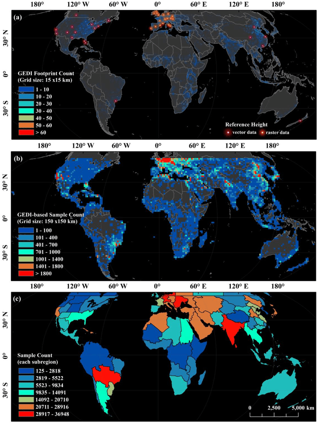
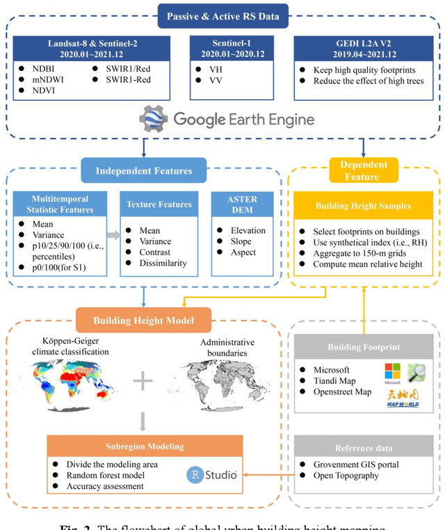
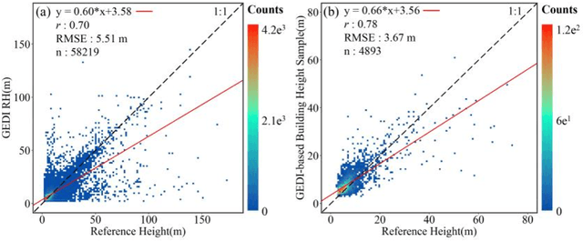
Characterizing urban environments with broad coverages and high precision is more important than ever for achieving the UN's Sustainable Development Goals (SDGs) as half of the world's populations are living in cities. Urban building height as a fundamental 3D urban structural feature has far-reaching applications. However, so far, producing readily available datasets of recent urban building heights with fine spatial resolutions and global coverages remains a challenging task. Here, we provide an up-to-date global product of urban building heights based on a fine grid size of 150 m around 2020 by combining the spaceborne lidar instrument of GEDI and multi-sourced data including remotely sensed images (i.e., Landsat-8, Sentinel-2, and Sentinel-1) and topographic data. Our results revealed that the estimated method of building height samples based on the GEDI data was effective with 0.78 of Pearson's r and 3.67 m of RMSE in comparison to the reference data. The mapping product also demonstrated good performance as indicated by its strong correlation with the reference data (i.e., Pearson's r = 0.71, RMSE = 4.60 m). Compared with the currently existing products, our global urban building height map holds the ability to provide a higher spatial resolution (i.e., 150 m) with a great level of inherent details about the spatial heterogeneity and flexibility of updating using the GEDI samples as inputs. This work will boost future urban studies across many fields including climate, environmental, ecological, and social sciences.