Hock Beng Lim
Distance Measurement for UAVs in Deep Hazardous Tunnels
Sep 11, 2024

Abstract:The localization of Unmanned aerial vehicles (UAVs) in deep tunnels is extremely challenging due to their inaccessibility and hazardous environment. Conventional outdoor localization techniques (such as using GPS) and indoor localization techniques (such as those based on WiFi, Infrared (IR), Ultra-Wideband, etc.) do not work in deep tunnels. We are developing a UAV-based system for the inspection of defects in the Deep Tunnel Sewerage System (DTSS) in Singapore. To enable the UAV localization in the DTSS, we have developed a distance measurement module based on the optical flow technique. However, the standard optical flow technique does not work well in tunnels with poor lighting and a lack of features. Thus, we have developed an enhanced optical flow algorithm with prediction, to improve the distance measurement for UAVs in deep hazardous tunnels.
A GPS Pseudorange Based Cooperative Vehicular Distance Measurement Technique
Jul 11, 2012


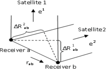
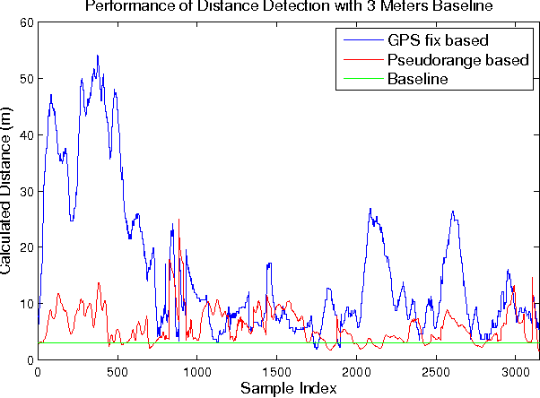
Abstract:Accurate vehicular localization is important for various cooperative vehicle safety (CVS) applications such as collision avoidance, turning assistant, etc. In this paper, we propose a cooperative vehicular distance measurement technique based on the sharing of GPS pseudorange measurements and a weighted least squares method. The classic double difference pseudorange solution, which was originally designed for high-end survey level GPS systems, is adapted to low-end navigation level GPS receivers for its wide availability in ground vehicles. The Carrier to Noise Ratio (CNR) of raw pseudorange measurements are taken into account for noise mitigation. We present a Dedicated Short Range Communications (DSRC) based mechanism to implement the exchange of pseudorange information among neighboring vehicles. As demonstrated in field tests, our proposed technique increases the accuracy of the distance measurement significantly compared with the distance obtained from the GPS fixes.
 Add to Chrome
 Add to Firefox
 Add to Edge