Hannes Taubenböck
Mapping Reduced Accessibility to WASH Facilities in Rohingya Refugee Camps With Sub-Meter Imagery
Nov 18, 2025Abstract:Access to Water, Sanitation, and Hygiene (WASH) services remains a major public health concern in refugee camps. This study introduces a remote sensing-driven framework to quantify WASH accessibility-specifically to water pumps, latrines, and bathing cubicles-in the Rohingya camps of Cox's Bazar, one of the world's most densely populated displacement settings. Detecting refugee shelters in such emergent camps presents substantial challenges, primarily due to their dense spatial configuration and irregular geometric patterns. Using sub-meter satellite images, we develop a semi-supervised segmentation framework that achieves an F1-score of 76.4% in detecting individual refugee shelters. Applying the framework across multi-year data reveals declining WASH accessibility, driven by rapid refugee population growth and reduced facility availability, rising from 25 people per facility in 2022 to 29.4 in 2025. Gender-disaggregated analysis further shows that women and girls experience reduced accessibility, in scenarios with inadequate safety-related segregation in WASH facilities. These findings suggest the importance of demand-responsive allocation strategies that can identify areas with under-served populations-such as women and girls-and ensure that limited infrastructure serves the greatest number of people in settings with fixed or shrinking budgets. We also discuss the value of high-resolution remote sensing and machine learning to detect inequality and inform equitable resource planning in complex humanitarian environments.
Geo-Information Harvesting from Social Media Data
Nov 01, 2022Abstract:As unconventional sources of geo-information, massive imagery and text messages from open platforms and social media form a temporally quasi-seamless, spatially multi-perspective stream, but with unknown and diverse quality. Due to its complementarity to remote sensing data, geo-information from these sources offers promising perspectives, but harvesting is not trivial due to its data characteristics. In this article, we address key aspects in the field, including data availability, analysis-ready data preparation and data management, geo-information extraction from social media text messages and images, and the fusion of social media and remote sensing data. We then showcase some exemplary geographic applications. In addition, we present the first extensive discussion of ethical considerations of social media data in the context of geo-information harvesting and geographic applications. With this effort, we wish to stimulate curiosity and lay the groundwork for researchers who intend to explore social media data for geo-applications. We encourage the community to join forces by sharing their code and data.
So2Sat POP -- A Curated Benchmark Data Set for Population Estimation from Space on a Continental Scale
Apr 07, 2022


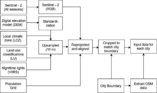
Abstract:Obtaining a dynamic population distribution is key to many decision-making processes such as urban planning, disaster management and most importantly helping the government to better allocate socio-technical supply. For the aspiration of these objectives, good population data is essential. The traditional method of collecting population data through the census is expensive and tedious. In recent years, machine learning methods have been developed to estimate the population distribution. Most of the methods use data sets that are either developed on a small scale or not publicly available yet. Thus, the development and evaluation of the new methods become challenging. We fill this gap by providing a comprehensive data set for population estimation in 98 European cities. The data set comprises digital elevation model, local climate zone, land use classifications, nighttime lights in combination with multi-spectral Sentinel-2 imagery, and data from the Open Street Map initiative. We anticipate that it would be a valuable addition to the research community for the development of sophisticated machine learning-based approaches in the field of population estimation.
Building Instance Classification Using Street View Images
Feb 25, 2018


Abstract:Land-use classification based on spaceborne or aerial remote sensing images has been extensively studied over the past decades. Such classification is usually a patch-wise or pixel-wise labeling over the whole image. But for many applications, such as urban population density mapping or urban utility planning, a classification map based on individual buildings is much more informative. However, such semantic classification still poses some fundamental challenges, for example, how to retrieve fine boundaries of individual buildings. In this paper, we proposed a general framework for classifying the functionality of individual buildings. The proposed method is based on Convolutional Neural Networks (CNNs) which classify facade structures from street view images, such as Google StreetView, in addition to remote sensing images which usually only show roof structures. Geographic information was utilized to mask out individual buildings, and to associate the corresponding street view images. We created a benchmark dataset which was used for training and evaluating CNNs. In addition, the method was applied to generate building classification maps on both region and city scales of several cities in Canada and the US. Keywords: CNN, Building instance classification, Street view images, OpenStreetMap
 Add to Chrome
 Add to Firefox
 Add to Edge