Guillermo Terrén-Serrano
Extreme Scenario Selection in Day-Ahead Power Grid Operational Planning
Sep 20, 2023Abstract:We propose and analyze the application of statistical functional depth metrics for the selection of extreme scenarios in day-ahead grid planning. Our primary motivation is screening of probabilistic scenarios for realized load and renewable generation, in order to identify scenarios most relevant for operational risk mitigation. To handle the high-dimensionality of the scenarios across asset classes and intra-day periods, we employ functional measures of depth to sub-select outlying scenarios that are most likely to be the riskiest for the grid operation. We investigate a range of functional depth measures, as well as a range of operational risks, including load shedding, operational costs, reserves shortfall and variable renewable energy curtailment. The effectiveness of the proposed screening approach is demonstrated through a case study on the realistic Texas-7k grid.
Review of Kernel Learning for Intra-Hour Solar Forecasting with Infrared Sky Images and Cloud Dynamic Feature Extraction
Oct 11, 2021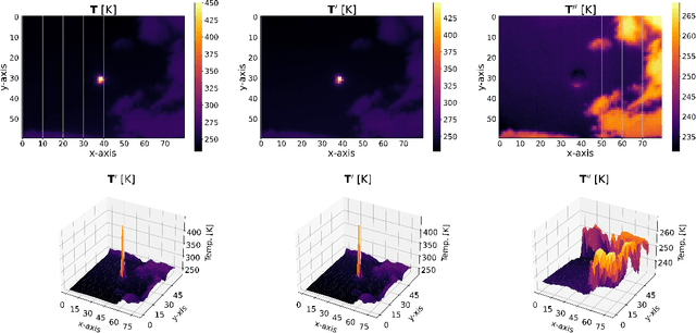
Abstract:The uncertainty of the energy generated by photovoltaic systems incurs an additional cost for a guaranteed, reliable supply of energy (i.e., energy storage). This investigation aims to decrease the additional cost by introducing probabilistic multi-task intra-hour solar forecasting (feasible in real time applications) to increase the penetration of photovoltaic systems in power grids. The direction of moving clouds is estimated in consecutive sequences of sky images by extracting features of cloud dynamics with the objective of forecasting the global solar irradiance that reaches photovoltaic systems. The sky images are acquired using a low-cost infrared sky imager mounted on a solar tracker. The solar forecasting algorithm is based on kernel learning methods, and uses the clear sky index as predictor and features extracted from clouds as feature vectors. The proposed solar forecasting algorithm achieved 16.45\% forecasting skill 8 minutes ahead with a resolution of 15 seconds. In contrast, previous work reached 15.4\% forecasting skill with the resolution of 1 minute. Therefore, this solar forecasting algorithm increases the performances with respect to the state-of-the-art, providing grid operators with the capability of managing the inherent uncertainties of power grids with a high penetration of photovoltaic systems.
Detection of Clouds in Multiple Wind Velocity Fields using Ground-based Infrared Sky Images
Jun 03, 2021
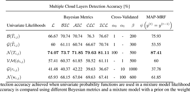
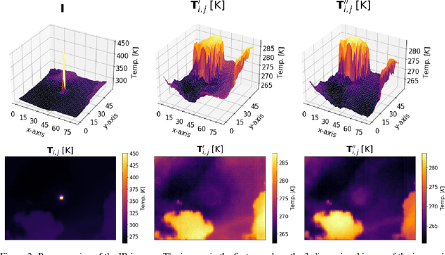
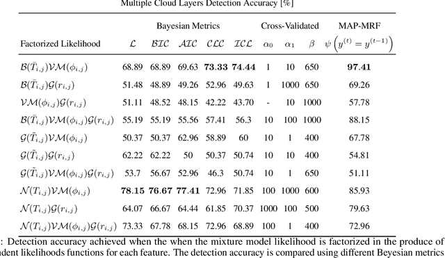
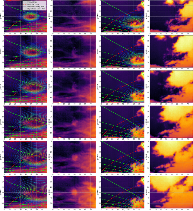
Abstract:Horizontal atmospheric wind shear causes wind velocity fields to have different directions and speeds. In images of clouds acquired using ground-based sky imagers, clouds may be moving in different wind layers. To increase the performance of an intra-hour global solar irradiance forecasting algorithm, it is important to detect multiple layers of clouds. The information provided by a solar forecasting algorithm is necessary to optimize and schedule the solar generation resources and storage devices in a smart grid. This investigation studies the performance of unsupervised learning techniques when detecting the number of cloud layers in infrared sky images. The images are acquired using an innovative infrared sky imager mounted on a solar tracker. Different mixture models are used to infer the distribution of the cloud features. The optimal decision criterion to find the number of clusters in the mixture models is analyzed and compared between different Bayesian metrics and a sequential hidden Markov model. The motion vectors are computed using a weighted implementation of the Lucas-Kanade algorithm. The correlations between the cloud velocity vectors and temperatures are analyzed to find the method that leads to the most accurate results. We have found that the sequential hidden Markov model outperformed the detection accuracy of the Bayesian metrics.
Geospatial Transformations for Ground-Based Sky Imaging Systems
Mar 09, 2021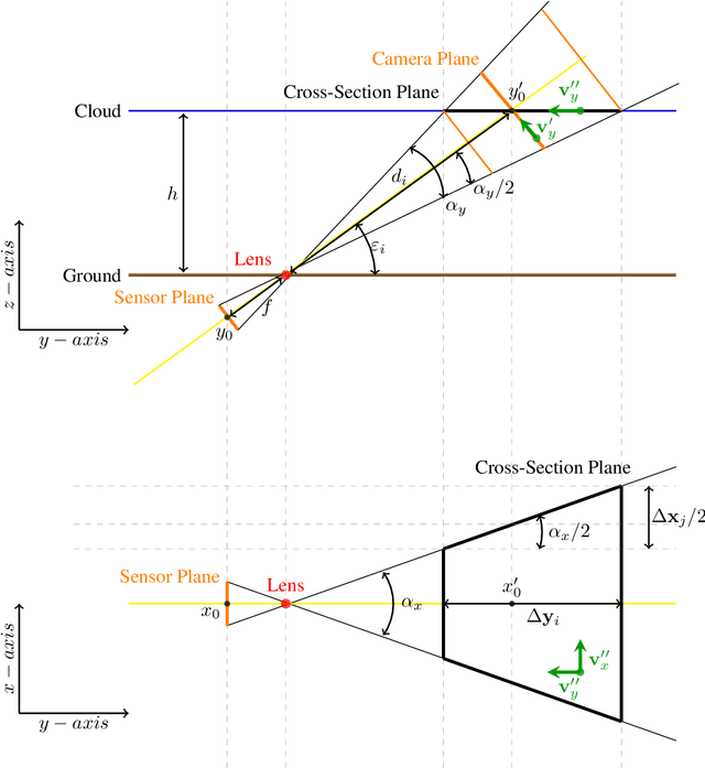
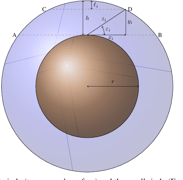
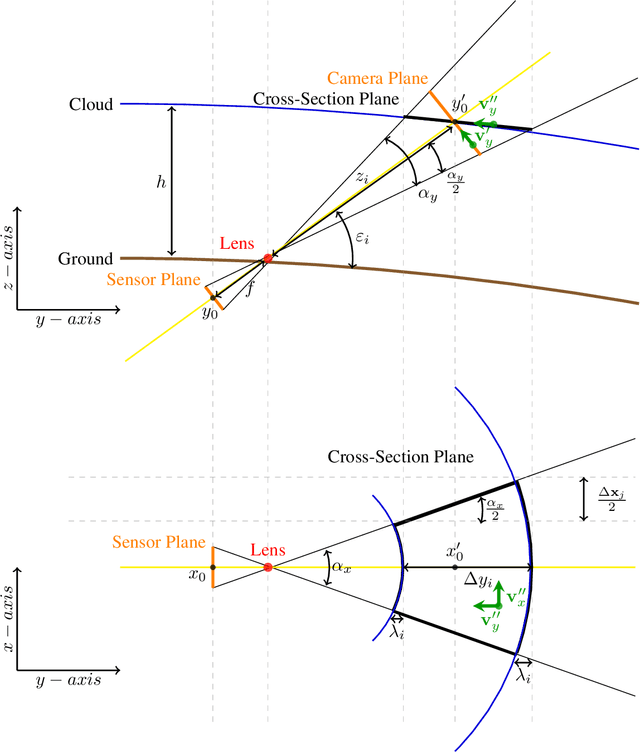

Abstract:Sky imaging systems use lenses to acquire images concentrating light beams in an imager. The light beams received by the sky imager have an elevation angle with respect to the normal of the device. This produces that the image pixels contain information from different areas of the sky within the imaging system Field Of View (FOV). The area of the field of view contained in the pixels increases as the elevation angle of the incident light beams decreases. When the sky imagers are mounted on a solar tracker incidence angle of the light beam on a pixel varies over time. This investigation introduces a transformation that projects the original euclidean frame of the imager plane to the geospatial frame atmosphere cross-section plane form when the sky imager field of view intersects the tropopause.
Wind Flow Estimation in Thermal Sky Images for Sun Occlusion Prediction
Mar 03, 2021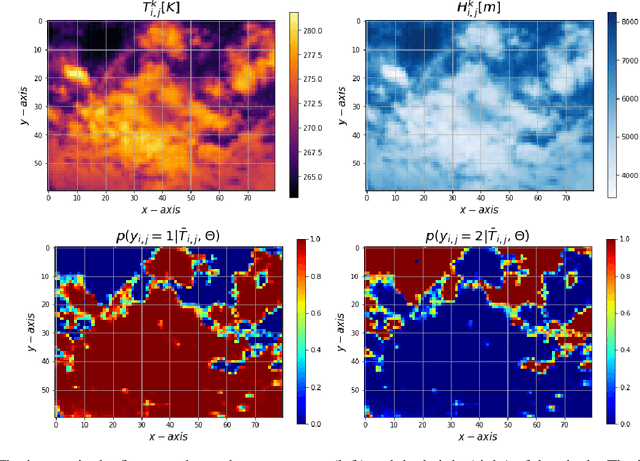
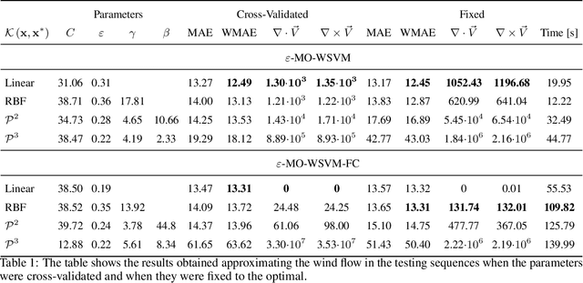
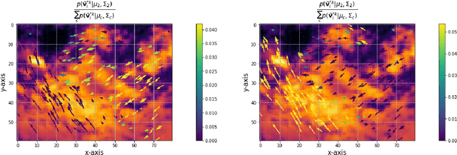

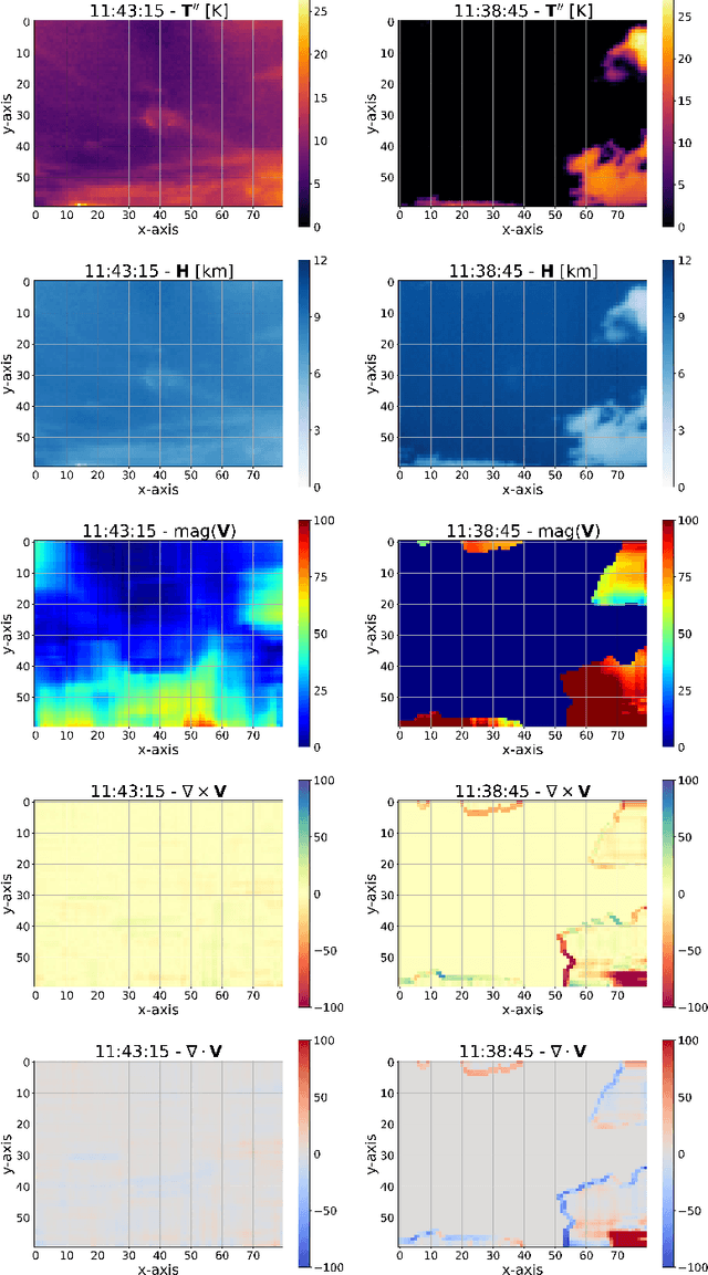
Abstract:Moving clouds affect the global solar irradiance that reaches the surface of the Earth. As a consequence, the amount of resources available to meet the energy demand in a smart grid powered using Photovoltaic (PV) systems depends on the shadows projected by passing clouds. This research introduces an algorithm for tracking clouds to predict Sun occlusion. Using thermal images of clouds, the algorithm is capable of estimating multiple wind velocity fields with different altitudes, velocity magnitudes and directions.
Unsupervised Segmentation Algorithms for Infrared Cloud Images
Mar 03, 2021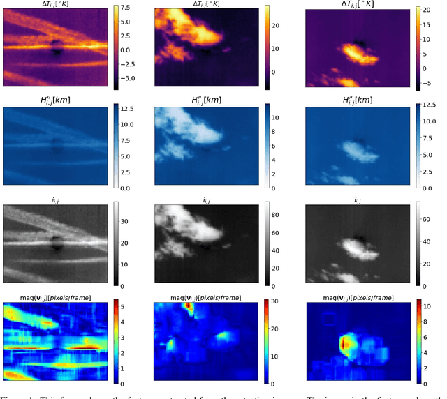
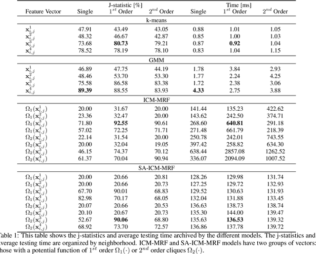
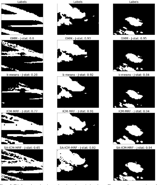
Abstract:The increasing number of Photovoltaic (PV) systems connected to the power grids makes them vulnerable to the projection of shadows from moving clouds. Solar Global Irradiance (GSI) forecasting allows smart grids to optimize energy dispatch preventing cloud coverage shortages. This investigation compares the performances of unsupervised learning algorithms (not requiring labelled images for training) for real-time segmentation of clouds in a ground-base infrared sky-imaging system, which is commonly used to extract cloud features using only the pixels where clouds are detected.
Girasol, a Sky Imaging and Global Solar Irradiance Dataset
Feb 26, 2021

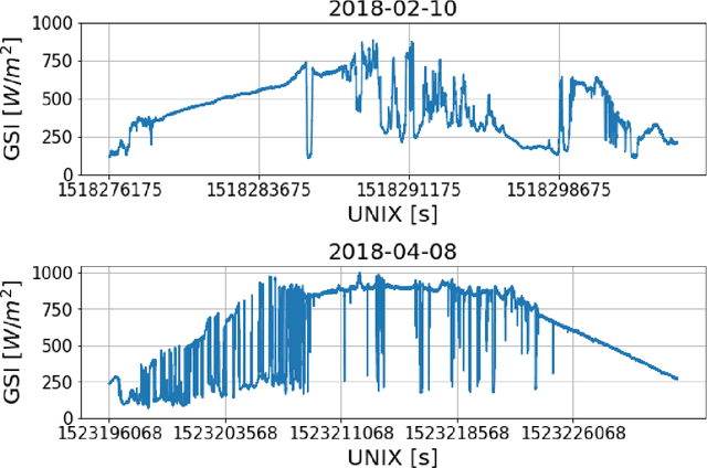
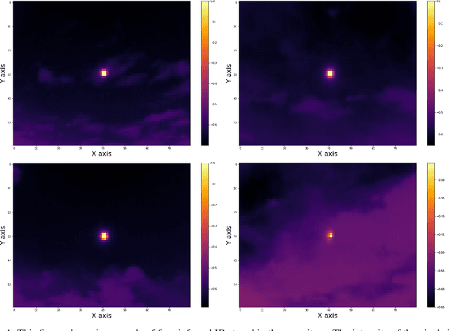
Abstract:The energy available in Micro Grid (MG) that is powered by solar energy is tightly related to the weather conditions in the moment of generation. Very short-term forecast of solar irradiance provides the MG with the capability of automatically controlling the dispatch of energy. We propose to achieve this using a data acquisition systems (DAQ) that simultaneously records sky imaging and Global Solar Irradiance (GSI) measurements, with the objective of extracting features from clouds and use them to forecast the power produced by a Photovoltaic (PV) system. The DAQ system is nicknamed as the \emph{Girasol Machine} (Girasol means Sunflower in Spanish). The sky imaging system consists of a longwave infrared (IR) camera and a visible (VI) light camera with a fisheye lens attached to it. The cameras are installed inside a weatherproof enclosure that it is mounted on an outdoor tracker. The tracker updates its pan an tilt every second using a solar position algorithm to maintain the Sun in the center of the IR and VI images. A pyranometer is situated on a horizontal support next to the DAQ system to measure GSI. The dataset, composed of IR images, VI images, GSI measurements, and the Sun's positions, has been tagged with timestamps.
Explicit Basis Function Kernel Methods for Cloud Segmentation in Infrared Sky Images
Feb 19, 2021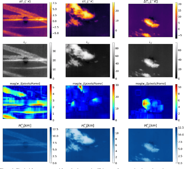
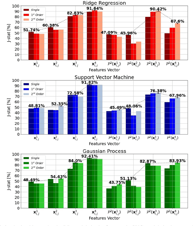
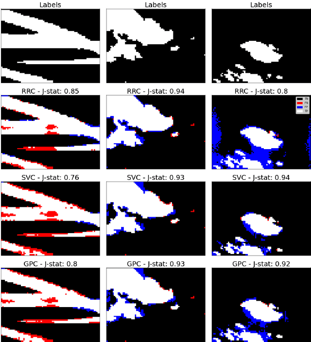
Abstract:Photovoltaic (PV) systems are sensitive to cloud shadow projection, which needs to be forecasted to reduce the noise impacting the short-term forecast of Global Solar Irradiance (GSI). We present a comparison between different kernel discriminative models for cloud detection. The models are solved in the primal formulation to make them feasible in real-time applications. The performances are compared using the j-statistic. The Infrared (IR) images have been preprocessed to remove debris, which increases the performance of the analyzed methods. The use of the pixels neighboring features also leads to a performance improvement. Discriminative models solved in the primal yield a dramatically lower computing time along with high performance in the segmentation.
Data Processing for Short-Term Solar Irradiance Forecasting using Ground-Based Infrared Images
Jan 21, 2021
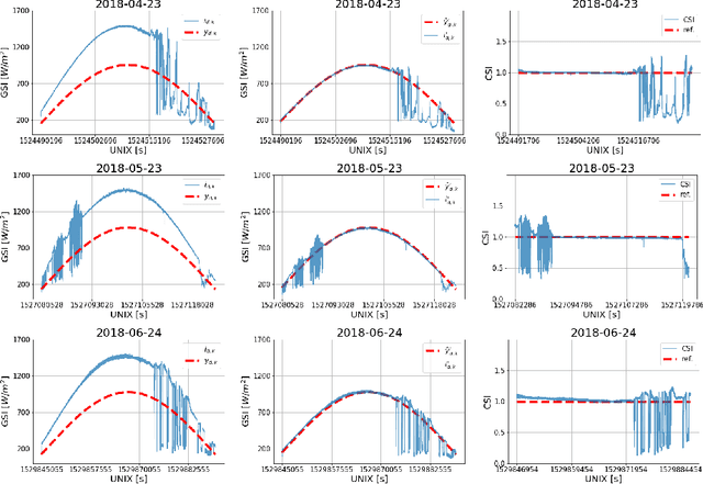


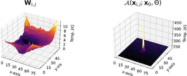
Abstract:The generation of energy in a power grid which uses Photovoltaic (PV) systems depends on the projection of shadows from moving clouds in the Troposphere. This investigation proposes an efficient method of data processing for the statistical quantification of cloud features using long-wave infrared (IR) images and Global Solar Irradiance (GSI) measurements. The IR images are obtained using a data acquisition system (DAQ) mounted on a solar tracker. We explain how to remove cyclostationary biases in GSI measurements. Seasonal trends are removed from the GSI time series, using the theoretical GSI to obtain the Clear-Sky Index (CSI) time series. We introduce an atmospheric model to remove from IR images both the effect of atmosphere scatter irradiance and the effect of the Sun's direct irradiance. Scattering is produced by water spots and dust particles on the germanium lens of the enclosure. We explain how to remove the scattering effect produced by the germanium lens attached to the DAQ enclosure window of the IR camera. An atmospheric condition model classifies the sky-conditions in four different categories: clear-sky, cumulus, stratus and nimbus. When an IR image is classified in the category of clear-sky, it is used to model the scattering effect of the germanium lens.
 Add to Chrome
 Add to Firefox
 Add to Edge