 Add to Chrome
 Add to Firefox
 Add to Edge
Turin3D: Evaluating Adaptation Strategies under Label Scarcity in Urban LiDAR Segmentation with Semi-Supervised Techniques
Apr 08, 20253D semantic segmentation plays a critical role in urban modelling, enabling detailed understanding and mapping of city environments. In this paper, we introduce Turin3D: a new aerial LiDAR dataset for point cloud semantic segmentation covering an area of around 1.43 km2 in the city centre of Turin with almost 70M points. We describe the data collection process and compare Turin3D with others previously proposed in the literature. We did not fully annotate the dataset due to the complexity and time-consuming nature of the process; however, a manual annotation process was performed on the validation and test sets, to enable a reliable evaluation of the proposed techniques. We first benchmark the performances of several point cloud semantic segmentation models, trained on the existing datasets, when tested on Turin3D, and then improve their performances by applying a semi-supervised learning technique leveraging the unlabelled training set. The dataset will be publicly available to support research in outdoor point cloud segmentation, with particular relevance for self-supervised and semi-supervised learning approaches given the absence of ground truth annotations for the training set.
Maximum Temperature Prediction Using Remote Sensing Data Via Convolutional Neural Network
May 31, 2024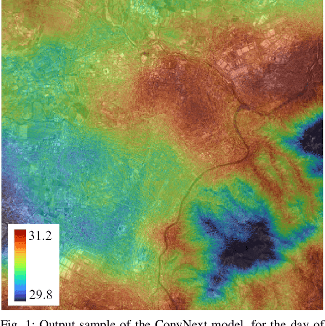
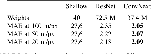
Urban heat islands, defined as specific zones exhibiting substantially higher temperatures than their immediate environs, pose significant threats to environmental sustainability and public health. This study introduces a novel machine-learning model that amalgamates data from the Sentinel-3 satellite, meteorological predictions, and additional remote sensing inputs. The primary aim is to generate detailed spatiotemporal maps that forecast the peak temperatures within a 24-hour period in Turin. Experimental results validate the model's proficiency in predicting temperature patterns, achieving a Mean Absolute Error (MAE) of 2.09 degrees Celsius for the year 2023 at a resolution of 20 meters per pixel, thereby enriching our knowledge of urban climatic behavior. This investigation enhances the understanding of urban microclimates, emphasizing the importance of cross-disciplinary data integration, and laying the groundwork for informed policy-making aimed at alleviating the negative impacts of extreme urban temperatures.
Urban Air Pollution Forecasting: a Machine Learning Approach leveraging Satellite Observations and Meteorological Forecasts
May 30, 2024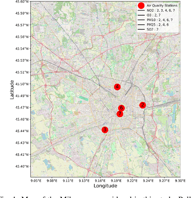
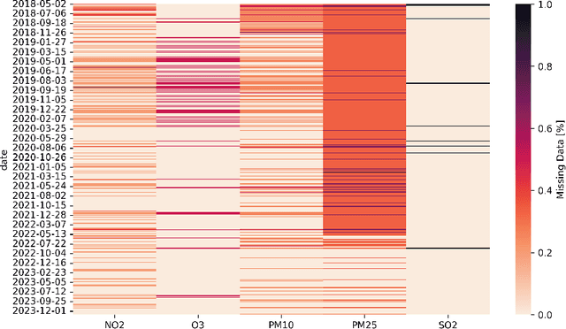
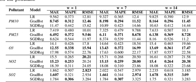
Air pollution poses a significant threat to public health and well-being, particularly in urban areas. This study introduces a series of machine-learning models that integrate data from the Sentinel-5P satellite, meteorological conditions, and topological characteristics to forecast future levels of five major pollutants. The investigation delineates the process of data collection, detailing the combination of diverse data sources utilized in the study. Through experiments conducted in the Milan metropolitan area, the models demonstrate their efficacy in predicting pollutant levels for the forthcoming day, achieving a percentage error of around 30%. The proposed models are advantageous as they are independent of monitoring stations, facilitating their use in areas without existing infrastructure. Additionally, we have released the collected dataset to the public, aiming to stimulate further research in this field. This research contributes to advancing our understanding of urban air quality dynamics and emphasizes the importance of amalgamating satellite, meteorological, and topographical data to develop robust pollution forecasting models.