Francisco Dorr
M3LEO: A Multi-Modal, Multi-Label Earth Observation Dataset Integrating Interferometric SAR and RGB Data
Jun 06, 2024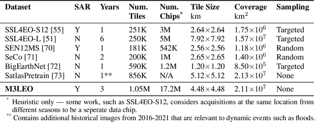
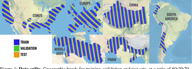
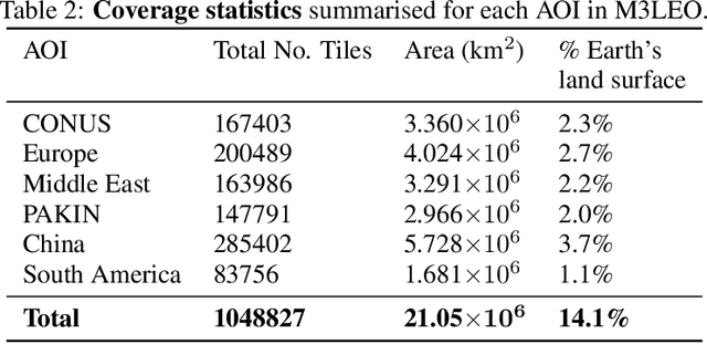
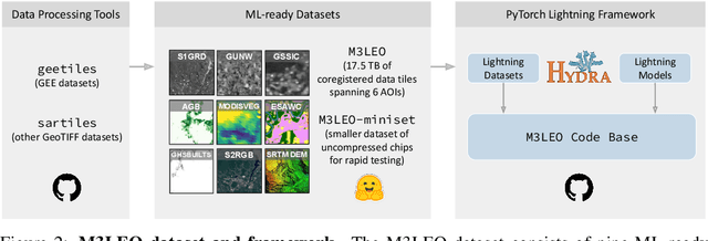
Abstract:Satellite-based remote sensing has revolutionised the way we address global challenges in a rapidly evolving world. Huge quantities of Earth Observation (EO) data are generated by satellite sensors daily, but processing these large datasets for use in ML pipelines is technically and computationally challenging. Specifically, different types of EO data are often hosted on a variety of platforms, with differing availability for Python preprocessing tools. In addition, spatial alignment across data sources and data tiling can present significant technical hurdles for novice users. While some preprocessed EO datasets exist, their content is often limited to optical or near-optical wavelength data, which is ineffective at night or in adverse weather conditions. Synthetic Aperture Radar (SAR), an active sensing technique based on microwave length radiation, offers a viable alternative. However, the application of machine learning to SAR has been limited due to a lack of ML-ready data and pipelines, particularly for the full diversity of SAR data, including polarimetry, coherence and interferometry. We introduce M3LEO, a multi-modal, multi-label EO dataset that includes polarimetric, interferometric, and coherence SAR data derived from Sentinel-1, alongside Sentinel-2 RGB imagery and a suite of labelled tasks for model evaluation. M3LEO spans 17.5TB and contains approximately 10M data chips across six geographic regions. The dataset is complemented by a flexible PyTorch Lightning framework, with configuration management using Hydra. We provide tools to process any dataset available on popular platforms such as Google Earth Engine for integration with our framework. Initial experiments validate the utility of our data and framework, showing that SAR imagery contains information additional to that extractable from RGB data. Data at huggingface.co/M3LEO, and code at github.com/spaceml-org/M3LEO.
Exploring DINO: Emergent Properties and Limitations for Synthetic Aperture Radar Imagery
Oct 05, 2023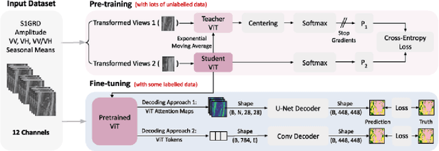
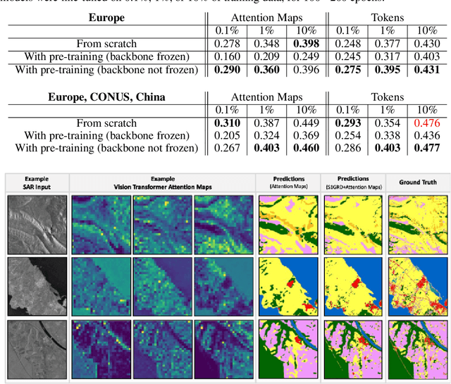
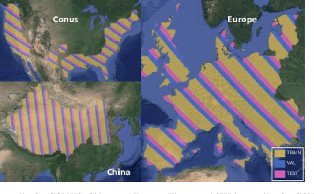
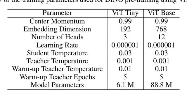
Abstract:Self-supervised learning (SSL) models have recently demonstrated remarkable performance across various tasks, including image segmentation. This study delves into the emergent characteristics of the Self-Distillation with No Labels (DINO) algorithm and its application to Synthetic Aperture Radar (SAR) imagery. We pre-train a vision transformer (ViT)-based DINO model using unlabeled SAR data, and later fine-tune the model to predict high-resolution land cover maps. We rigorously evaluate the utility of attention maps generated by the ViT backbone, and compare them with the model's token embedding space. We observe a small improvement in model performance with pre-training compared to training from scratch, and discuss the limitations and opportunities of SSL for remote sensing and land cover segmentation. Beyond small performance increases, we show that ViT attention maps hold great intrinsic value for remote sensing, and could provide useful inputs to other algorithms. With this, our work lays the ground-work for bigger and better SSL models for Earth Observation.
Exploring Generalisability of Self-Distillation with No Labels for SAR-Based Vegetation Prediction
Oct 03, 2023Abstract:In this work we pre-train a DINO-ViT based model using two Synthetic Aperture Radar datasets (S1GRD or GSSIC) across three regions (China, Conus, Europe). We fine-tune the models on smaller labeled datasets to predict vegetation percentage, and empirically study the connection between the embedding space of the models and their ability to generalize across diverse geographic regions and to unseen data. For S1GRD, embedding spaces of different regions are clearly separated, while GSSIC's overlaps. Positional patterns remain during fine-tuning, and greater distances in embeddings often result in higher errors for unfamiliar regions. With this, our work increases our understanding of generalizability for self-supervised models applied to remote sensing.
Large Scale Masked Autoencoding for Reducing Label Requirements on SAR Data
Oct 02, 2023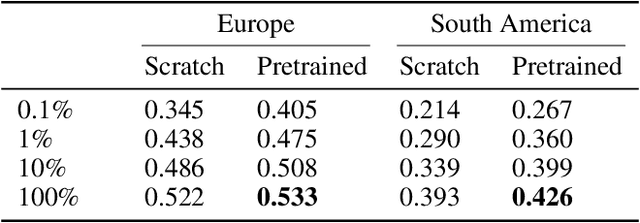
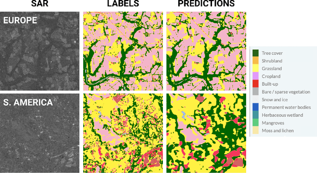
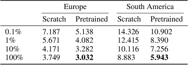
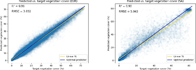
Abstract:Satellite-based remote sensing is instrumental in the monitoring and mitigation of the effects of anthropogenic climate change. Large scale, high resolution data derived from these sensors can be used to inform intervention and policy decision making, but the timeliness and accuracy of these interventions is limited by use of optical data, which cannot operate at night and is affected by adverse weather conditions. Synthetic Aperture Radar (SAR) offers a robust alternative to optical data, but its associated complexities limit the scope of labelled data generation for traditional deep learning. In this work, we apply a self-supervised pretraining scheme, masked autoencoding, to SAR amplitude data covering 8.7\% of the Earth's land surface area, and tune the pretrained weights on two downstream tasks crucial to monitoring climate change - vegetation cover prediction and land cover classification. We show that the use of this pretraining scheme reduces labelling requirements for the downstream tasks by more than an order of magnitude, and that this pretraining generalises geographically, with the performance gain increasing when tuned downstream on regions outside the pretraining set. Our findings significantly advance climate change mitigation by facilitating the development of task and region-specific SAR models, allowing local communities and organizations to deploy tailored solutions for rapid, accurate monitoring of climate change effects.
Fewshot learning on global multimodal embeddings for earth observation tasks
Sep 29, 2023Abstract:In this work we pretrain a CLIP/ViT based model using three different modalities of satellite imagery across five AOIs covering over ~10\% of the earth total landmass, namely Sentinel 2 RGB optical imagery, Sentinel 1 SAR amplitude and Sentinel 1 SAR interferometric coherence. This model uses $\sim 250$ M parameters. Then, we use the embeddings produced for each modality with a classical machine learning method to attempt different downstream tasks for earth observation related to vegetation, built up surface, croplands and permanent water. We consistently show how we reduce the need for labeled data by 99\%, so that with ~200-500 randomly selected labeled examples (around 4K-10K km$^2$) we reach performance levels analogous to those achieved with the full labeled datasets (about 150K image chips or 3M km$^2$ in each AOI) on all modalities, AOIs and downstream tasks. This leads us to think that the model has captured significant earth features useful in a wide variety of scenarios. To enhance our model's usability in practice, its architecture allows inference in contexts with missing modalities and even missing channels within each modality. Additionally, we visually show that this embedding space, obtained with no labels, is sensible to the different earth features represented by the labelled datasets we selected.
 Add to Chrome
 Add to Firefox
 Add to Edge