David Coomes
Semi-supervised Learning with Graphs: Covariance Based Superpixels For Hyperspectral Image Classification
Jan 15, 2019


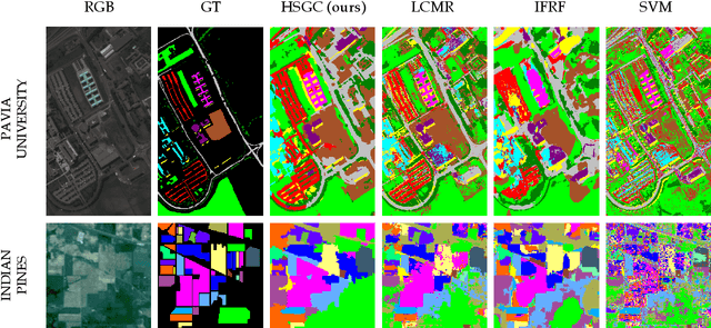
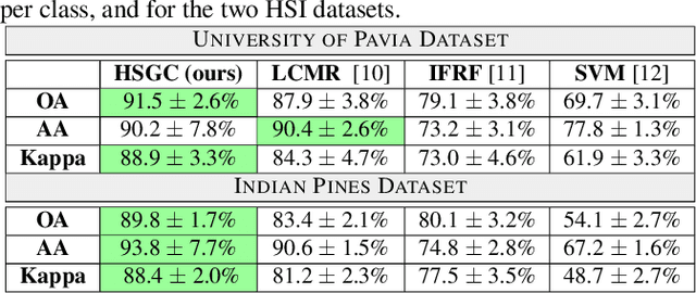
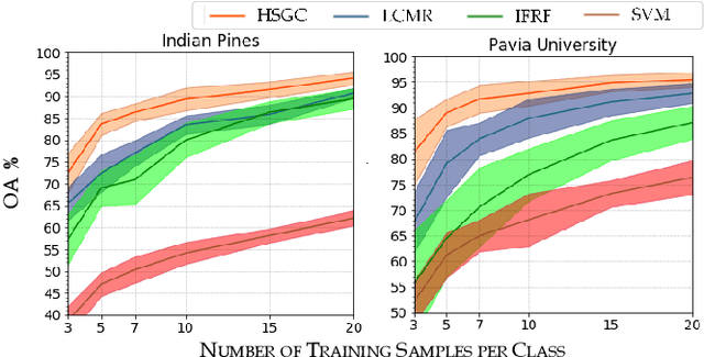
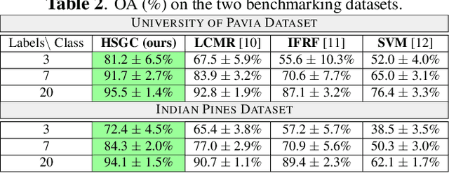
Abstract:In this paper, we present a graph-based semi-supervised framework for hyperspectral image classification. We first introduce a novel superpixel algorithm based on the spectral covariance matrix representation of pixels to provide a better representation of our data. We then construct a superpixel graph, based on carefully considered feature vectors, before performing classification. We demonstrate, through a set of experimental results using two benchmarking datasets, that our approach outperforms three state-of-the-art classification frameworks, especially when an extremely small amount of labelled data is used.
A graph cut approach to 3D tree delineation, using integrated airborne LiDAR and hyperspectral imagery
Jan 24, 2017


Abstract:Recognising individual trees within remotely sensed imagery has important applications in forest ecology and management. Several algorithms for tree delineation have been suggested, mostly based on locating local maxima or inverted basins in raster canopy height models (CHMs) derived from Light Detection And Ranging (LiDAR) data or photographs. However, these algorithms often lead to inaccurate estimates of forest stand characteristics due to the limited information content of raster CHMs. Here we develop a 3D tree delineation method which uses graph cut to delineate trees from the full 3D LiDAR point cloud, and also makes use of any optical imagery available (hyperspectral imagery in our case). First, conventional methods are used to locate local maxima in the CHM and generate an initial map of trees. Second, a graph is built from the LiDAR point cloud, fused with the hyperspectral data. For computational efficiency, the feature space of hyperspectral imagery is reduced using robust PCA. Third, a multi-class normalised cut is applied to the graph, using the initial map of trees to constrain the number of clusters and their locations. Finally, recursive normalised cut is used to subdivide, if necessary, each of the clusters identified by the initial analysis. We call this approach Multiclass Cut followed by Recursive Cut (MCRC). The effectiveness of MCRC was tested using three datasets: i) NewFor, ii) a coniferous forest in the Italian Alps, and iii) a deciduous woodland in the UK. The performance of MCRC was usually superior to that of other delineation methods, and was further improved by including high-resolution optical imagery. Since MCRC delineates the entire LiDAR point cloud in 3D, it allows individual crown characteristics to be measured. By making full use of the data available, graph cut has the potential to considerably improve the accuracy of tree delineation.
Non-parametric Image Registration of Airborne LiDAR, Hyperspectral and Photographic Imagery of Forests
Jul 28, 2014


Abstract:There is much current interest in using multi-sensor airborne remote sensing to monitor the structure and biodiversity of forests. This paper addresses the application of non-parametric image registration techniques to precisely align images obtained from multimodal imaging, which is critical for the successful identification of individual trees using object recognition approaches. Non-parametric image registration, in particular the technique of optimizing one objective function containing data fidelity and regularization terms, provides flexible algorithms for image registration. Using a survey of woodlands in southern Spain as an example, we show that non-parametric image registration can be successful at fusing datasets when there is little prior knowledge about how the datasets are interrelated (i.e. in the absence of ground control points). The validity of non-parametric registration methods in airborne remote sensing is demonstrated by a series of experiments. Precise data fusion is a prerequisite to accurate recognition of objects within airborne imagery, so non-parametric image registration could make a valuable contribution to the analysis pipeline.
 Add to Chrome
 Add to Firefox
 Add to Edge