Clemens Mosig
FORMSpoT: A Decade of Tree-Level, Country-Scale Forest Monitoring
Dec 18, 2025
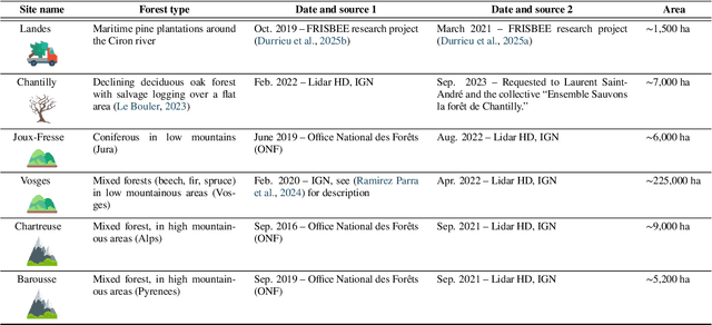
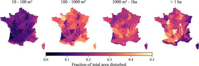
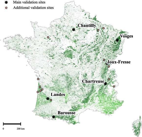
Abstract:The recent decline of the European forest carbon sink highlights the need for spatially explicit and frequently updated forest monitoring tools. Yet, existing satellite-based disturbance products remain too coarse to detect changes at the scale of individual trees, typically below 100 m$^{2}$. Here, we introduce FORMSpoT (Forest Mapping with SPOT Time series), a decade-long (2014-2024) nationwide mapping of forest canopy height at 1.5 m resolution, together with annual disturbance polygons (FORMSpoT-$Δ$) covering mainland France. Canopy heights were derived from annual SPOT-6/7 composites using a hierarchical transformer model (PVTv2) trained on high-resolution airborne laser scanning (ALS) data. To enable robust change detection across heterogeneous acquisitions, we developed a dedicated post-processing pipeline combining co-registration and spatio-temporal total variation denoising. Validation against ALS revisits across 19 sites and 5,087 National Forest Inventory plots shows that FORMSpoT-$Δ$ substantially outperforms existing disturbance products. In mountainous forests, where disturbances are small and spatially fragmented, FORMSpoT-$Δ$ achieves an F1-score of 0.44, representing an order of magnitude higher than existing benchmarks. By enabling tree-level monitoring of forest dynamics at national scale, FORMSpoT-$Δ$ provides a unique tool to analyze management practices, detect early signals of forest decline, and better quantify carbon losses from subtle disturbances such as thinning or selective logging. These results underscore the critical importance of sustaining very high-resolution satellite missions like SPOT and open-data initiatives such as DINAMIS for monitoring forests under climate change.
Context-Aware Multimodal Representation Learning for Spatio-Temporally Explicit Environmental Modelling
Nov 18, 2025


Abstract:Earth observation (EO) foundation models have emerged as an effective approach to derive latent representations of the Earth system from various remote sensing sensors. These models produce embeddings that can be used as analysis-ready datasets, enabling the modelling of ecosystem dynamics without extensive sensor-specific preprocessing. However, existing models typically operate at fixed spatial or temporal scales, limiting their use for ecological analyses that require both fine spatial detail and high temporal fidelity. To overcome these limitations, we propose a representation learning framework that integrates different EO modalities into a unified feature space at high spatio-temporal resolution. We introduce the framework using Sentinel-1 and Sentinel-2 data as representative modalities. Our approach produces a latent space at native 10 m resolution and the temporal frequency of cloud-free Sentinel-2 acquisitions. Each sensor is first modeled independently to capture its sensor-specific characteristics. Their representations are then combined into a shared model. This two-stage design enables modality-specific optimisation and easy extension to new sensors, retaining pretrained encoders while retraining only fusion layers. This enables the model to capture complementary remote sensing data and to preserve coherence across space and time. Qualitative analyses reveal that the learned embeddings exhibit high spatial and semantic consistency across heterogeneous landscapes. Quantitative evaluation in modelling Gross Primary Production reveals that they encode ecologically meaningful patterns and retain sufficient temporal fidelity to support fine-scale analyses. Overall, the proposed framework provides a flexible, analysis-ready representation learning approach for environmental applications requiring diverse spatial and temporal resolutions.
Transformers vs. Recurrent Models for Estimating Forest Gross Primary Production
Nov 14, 2025


Abstract:Monitoring the spatiotemporal dynamics of forest CO$_2$ uptake (Gross Primary Production, GPP), remains a central challenge in terrestrial ecosystem research. While Eddy Covariance (EC) towers provide high-frequency estimates, their limited spatial coverage constrains large-scale assessments. Remote sensing offers a scalable alternative, yet most approaches rely on single-sensor spectral indices and statistical models that are often unable to capture the complex temporal dynamics of GPP. Recent advances in deep learning (DL) and data fusion offer new opportunities to better represent the temporal dynamics of vegetation processes, but comparative evaluations of state-of-the-art DL models for multimodal GPP prediction remain scarce. Here, we explore the performance of two representative models for predicting GPP: 1) GPT-2, a transformer architecture, and 2) Long Short-Term Memory (LSTM), a recurrent neural network, using multivariate inputs. Overall, both achieve similar accuracy. But, while LSTM performs better overall, GPT-2 excels during extreme events. Analysis of temporal context length further reveals that LSTM attains similar accuracy using substantially shorter input windows than GPT-2, highlighting an accuracy-efficiency trade-off between the two architectures. Feature importance analysis reveals radiation as the dominant predictor, followed by Sentinel-2, MODIS land surface temperature, and Sentinel-1 contributions. Our results demonstrate how model architecture, context length, and multimodal inputs jointly determine performance in GPP prediction, guiding future developments of DL frameworks for monitoring terrestrial carbon dynamics.
Facilitating Advanced Sentinel-2 Analysis Through a Simplified Computation of Nadir BRDF Adjusted Reflectance
Apr 24, 2024
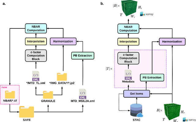

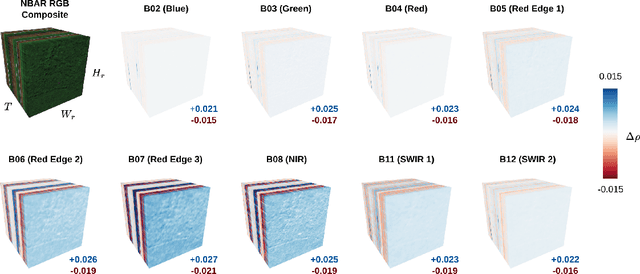
Abstract:The Sentinel-2 (S2) mission from the European Space Agency's Copernicus program provides essential data for Earth surface analysis. Its Level-2A products deliver high-to-medium resolution (10-60 m) surface reflectance (SR) data through the MultiSpectral Instrument (MSI). To enhance the accuracy and comparability of SR data, adjustments simulating a nadir viewing perspective are essential. These corrections address the anisotropic nature of SR and the variability in sun and observation angles, ensuring consistent image comparisons over time and under different conditions. The $c$-factor method, a simple yet effective algorithm, adjusts observed S2 SR by using the MODIS BRDF model to achieve Nadir BRDF Adjusted Reflectance (NBAR). Despite the straightforward application of the $c$-factor to individual images, a cohesive Python framework for its application across multiple S2 images and Earth System Data Cubes (ESDCs) from cloud-stored data has been lacking. Here we introduce sen2nbar, a Python package crafted to convert S2 SR data to NBAR, supporting both individual images and ESDCs derived from cloud-stored data. This package simplifies the conversion of S2 SR data to NBAR via a single function, organized into modules for efficient process management. By facilitating NBAR conversion for both SAFE files and ESDCs from SpatioTemporal Asset Catalogs (STAC), sen2nbar is developed as a flexible tool that can handle diverse data format requirements. We anticipate that sen2nbar will considerably contribute to the standardization and harmonization of S2 data, offering a robust solution for a diverse range of users across various applications. sen2nbar is an open-source tool available at https://github.com/ESDS-Leipzig/sen2nbar.
 Add to Chrome
 Add to Firefox
 Add to Edge