Burak Ekim
Distribution Shifts at Scale: Out-of-distribution Detection in Earth Observation
Dec 18, 2024Abstract:Training robust deep learning models is critical in Earth Observation, where globally deployed models often face distribution shifts that degrade performance, especially in low-data regions. Out-of-distribution (OOD) detection addresses this challenge by identifying inputs that differ from in-distribution (ID) data. However, existing methods either assume access to OOD data or compromise primary task performance, making them unsuitable for real-world deployment. We propose TARDIS, a post-hoc OOD detection method for scalable geospatial deployments. The core novelty lies in generating surrogate labels by integrating information from ID data and unknown distributions, enabling OOD detection at scale. Our method takes a pre-trained model, ID data, and WILD samples, disentangling the latter into surrogate ID and surrogate OOD labels based on internal activations, and fits a binary classifier as an OOD detector. We validate TARDIS on EuroSAT and xBD datasets, across 17 experimental setups covering covariate and semantic shifts, showing that it performs close to the theoretical upper bound in assigning surrogate ID and OOD samples in 13 cases. To demonstrate scalability, we deploy TARDIS on the Fields of the World dataset, offering actionable insights into pre-trained model behavior for large-scale deployments. The code is publicly available at https://github.com/microsoft/geospatial-ood-detection.
Mapping Land Naturalness from Sentinel-2 using Deep Contextual and Geographical Priors
Jun 27, 2024


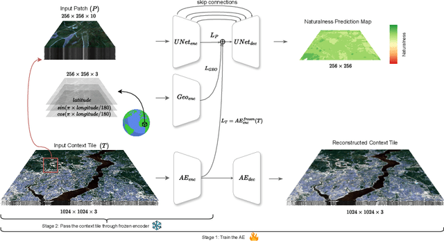
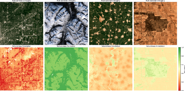
Abstract:In recent decades, the causes and consequences of climate change have accelerated, affecting our planet on an unprecedented scale. This change is closely tied to the ways in which humans alter their surroundings. As our actions continue to impact natural areas, using satellite images to observe and measure these effects has become crucial for understanding and combating climate change. Aiming to map land naturalness on the continuum of modern human pressure, we have developed a multi-modal supervised deep learning framework that addresses the unique challenges of satellite data and the task at hand. We incorporate contextual and geographical priors, represented by corresponding coordinate information and broader contextual information, including and surrounding the immediate patch to be predicted. Our framework improves the model's predictive performance in mapping land naturalness from Sentinel-2 data, a type of multi-spectral optical satellite imagery. Recognizing that our protective measures are only as effective as our understanding of the ecosystem, quantifying naturalness serves as a crucial step toward enhancing our environmental stewardship.
Explaining Multimodal Data Fusion: Occlusion Analysis for Wilderness Mapping
Apr 05, 2023


Abstract:Jointly harnessing complementary features of multi-modal input data in a common latent space has been found to be beneficial long ago. However, the influence of each modality on the models decision remains a puzzle. This study proposes a deep learning framework for the modality-level interpretation of multimodal earth observation data in an end-to-end fashion. While leveraging an explainable machine learning method, namely Occlusion Sensitivity, the proposed framework investigates the influence of modalities under an early-fusion scenario in which the modalities are fused before the learning process. We show that the task of wilderness mapping largely benefits from auxiliary data such as land cover and night time light data.
MapInWild: A Remote Sensing Dataset to Address the Question What Makes Nature Wild
Dec 05, 2022


Abstract:Antrophonegic pressure (i.e. human influence) on the environment is one of the largest causes of the loss of biological diversity. Wilderness areas, in contrast, are home to undisturbed ecological processes. However, there is no biophysical definition of the term wilderness. Instead, wilderness is more of a philosophical or cultural concept and thus cannot be easily delineated or categorized in a technical manner. With this paper, (i) we introduce the task of wilderness mapping by means of machine learning applied to satellite imagery (ii) and publish MapInWild, a large-scale benchmark dataset curated for that task. MapInWild is a multi-modal dataset and comprises various geodata acquired and formed from a diverse set of Earth observation sensors. The dataset consists of 8144 images with a shape of 1920 x 1920 pixels and is approximately 350 GB in size. The images are weakly annotated with three classes derived from the World Database of Protected Areas - Strict Nature Reserves, Wilderness Areas, and National Parks. With the dataset, which shall serve as a testbed for developments in fields such as explainable machine learning and environmental remote sensing, we hope to contribute to a deepening of our understanding of the question "What makes nature wild?".
A Multi-Task Deep Learning Framework for Building Footprint Segmentation
Apr 19, 2021


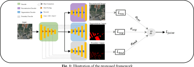
Abstract:The task of building footprint segmentation has been well-studied in the context of remote sensing (RS) as it provides valuable information in many aspects, however, difficulties brought by the nature of RS images such as variations in the spatial arrangements and in-consistent constructional patterns require studying further, since it often causes poorly classified segmentation maps. We address this need by designing a joint optimization scheme for the task of building footprint delineation and introducing two auxiliary tasks; image reconstruction and building footprint boundary segmentation with the intent to reveal the common underlying structure to advance the classification accuracy of a single task model under the favor of auxiliary tasks. In particular, we propose a deep multi-task learning (MTL) based unified fully convolutional framework which operates in an end-to-end manner by making use of joint loss function with learnable loss weights considering the homoscedastic uncertainty of each task loss. Experimental results conducted on the SpaceNet6 dataset demonstrate the potential of the proposed MTL framework as it improves the classification accuracy considerably compared to single-task and lesser compounded tasks.
 Add to Chrome
 Add to Firefox
 Add to Edge