Bingfang Wu
30m resolution Global Annual Burned Area Mapping based on Landsat images and Google Earth Engine
May 07, 2018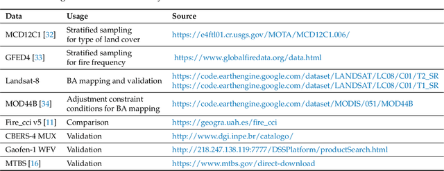
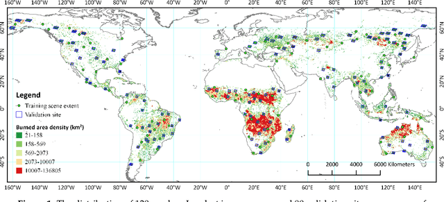

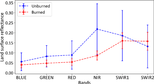
Abstract:Heretofore, global burned area (BA) products are only available at coarse spatial resolution, since most of the current global BA products are produced with the help of active fire detection or dense time-series change analysis, which requires very high temporal resolution. In this study, however, we focus on automated global burned area mapping approach based on Landsat images. By utilizing the huge catalog of satellite imagery as well as the high-performance computing capacity of Google Earth Engine, we proposed an automated pipeline for generating 30-meter resolution global-scale annual burned area map from time-series of Landsat images, and a novel 30-meter resolution global annual burned area map of 2015 (GABAM 2015) is released. GABAM 2015 consists of spatial extent of fires that occurred during 2015 and not of fires that occurred in previous years. Cross-comparison with recent Fire_cci version 5.0 BA product found a similar spatial distribution and a strong correlation ($R^2=0.74$) between the burned areas from the two products, although differences were found in specific land cover categories (particularly in agriculture land). Preliminary global validation showed the commission and omission error of GABAM 2015 are 13.17% and 30.13%, respectively.
Land use mapping in the Three Gorges Reservoir Area based on semantic segmentation deep learning method
Mar 18, 2018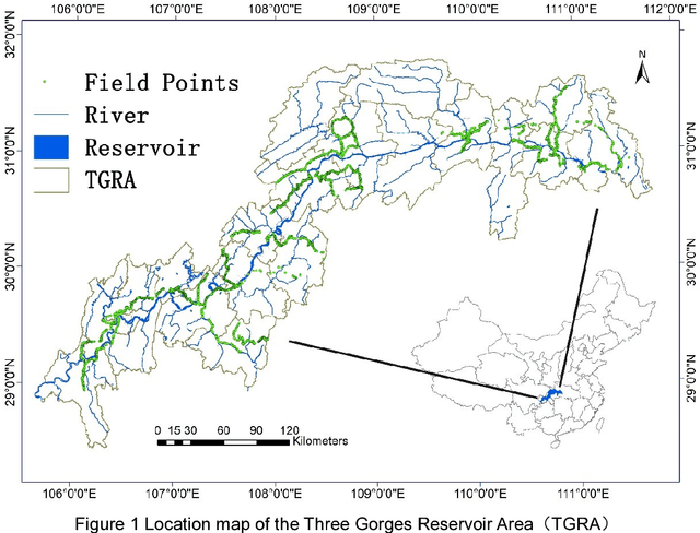
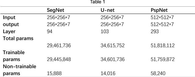

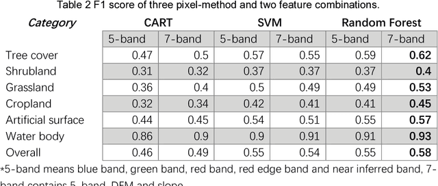
Abstract:The Three Gorges Dam, a massive cross-century project spans the Yangtze River by the town of Sandouping, located in Yichang, Hubei province, China, was built to provide great power, improve the River shipping, control floods in the upper reaches of the Yangtze River, and increase the dry season flow in the middle and lower reaches of the Yangtze River. Benefits are enormous and comprehensive. However, the social and environmental impacts are also immense and far-reaching to its surrounding areas. Mapping land use /land cover changed (LUCC) is critical for tracking the impacts. Remote sensing has been proved to be an effective way to map and monitor land use change in real time and in large areas such as the Three Gorges Reservoir Area(TGRA) by using pixel based or oriented based classifier in different resolution. In this paper, we first test the state of the art semantic segmentation deep learning classifiers for LUCC mapping with 7 categories in the TGRA area with rapideye 5m resolution data. The topographic information was also added for better accuracy in mountain area. By compared with the pixel-based classifier, the semantic segmentation deep learning method has better accuracy and robustness at 5m resolution level.
 Add to Chrome
 Add to Firefox
 Add to Edge