 Add to Chrome
 Add to Firefox
 Add to Edge
Are Pretrained Image Matchers Good Enough for SAR-Optical Satellite Registration?
Apr 14, 2026Cross-modal optical-SAR (Synthetic Aperture Radar) registration is a bottleneck for disaster-response via remote sensing, yet modern image matchers are developed and benchmarked almost exclusively on natural-image domains. We evaluate twenty-four pretrained matcher families--in a zero-shot setting with no fine-tuning or domain adaptation on satellite or SAR data--on SpaceNet9 and two additional cross-modal benchmarks under a deterministic protocol with tiled large-image inference, robust geometric filtering, and tie-point-grounded metrics. Our results reveal asymmetric transfer--matchers with explicit cross-modal training do not uniformly outperform those without it. While XoFTR (trained for visible-thermal matching) and RoMa achieve the lowest reported mean error at $3.0$ px on the labeled SpaceNet9 training scenes, RoMa achieves this without any cross-modal training, and MatchAnything-ELoFTR ($3.4$ px)--trained on synthetic cross-modal pairs--matches closely, suggesting (as a working hypothesis) that foundation-model features (DINOv2) may contribute to modality invariance that partially substitutes for explicit cross-modal supervision. 3D-reconstruction matchers (MASt3R, DUSt3R), which are not designed for traditional 2D image matching, are highly protocol-sensitive and remain fragile under default settings. Deployment protocol choices (geometry model, tile size, inlier gating) shift accuracy by up to $33\times$ for a single matcher, sometimes exceeding the effect of swapping matchers entirely within the evaluated sweep--affine geometry alone reduces mean error from $12.34$ to $9.74$ px. These findings inform both practical deployment of existing matchers and future matcher design for cross-modal satellite registration.
SPOC: Spatially-Progressing Object State Change Segmentation in Video
Mar 15, 2025Object state changes in video reveal critical information about human and agent activity. However, existing methods are limited to temporal localization of when the object is in its initial state (e.g., the unchopped avocado) versus when it has completed a state change (e.g., the chopped avocado), which limits applicability for any task requiring detailed information about the progress of the actions and its spatial localization. We propose to deepen the problem by introducing the spatially-progressing object state change segmentation task. The goal is to segment at the pixel-level those regions of an object that are actionable and those that are transformed. We introduce the first model to address this task, designing a VLM-based pseudo-labeling approach, state-change dynamics constraints, and a novel WhereToChange benchmark built on in-the-wild Internet videos. Experiments on two datasets validate both the challenge of the new task as well as the promise of our model for localizing exactly where and how fast objects are changing in video. We further demonstrate useful implications for tracking activity progress to benefit robotic agents. Project page: https://vision.cs.utexas.edu/projects/spoc-spatially-progressing-osc
AstroLoc: Robust Space to Ground Image Localizer
Feb 10, 2025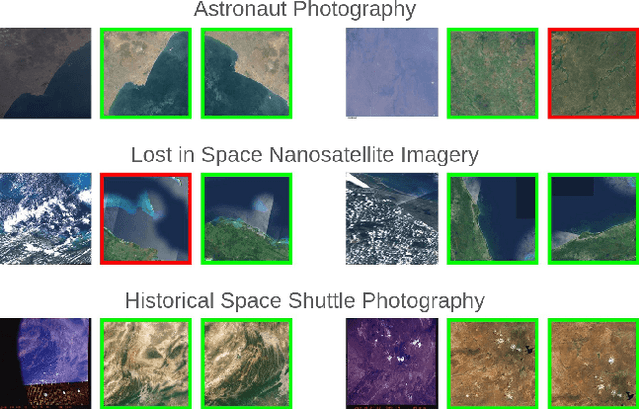

Astronauts take thousands of photos of Earth per day from the International Space Station, which, once localized on Earth's surface, are used for a multitude of tasks, ranging from climate change research to disaster management. The localization process, which has been performed manually for decades, has recently been approached through image retrieval solutions: given an astronaut photo, find its most similar match among a large database of geo-tagged satellite images, in a task called Astronaut Photography Localization (APL). Yet, existing APL approaches are trained only using satellite images, without taking advantage of the millions open-source astronaut photos. In this work we present the first APL pipeline capable of leveraging astronaut photos for training. We first produce full localization information for 300,000 manually weakly labeled astronaut photos through an automated pipeline, and then use these images to train a model, called AstroLoc. AstroLoc learns a robust representation of Earth's surface features through two losses: astronaut photos paired with their matching satellite counterparts in a pairwise loss, and a second loss on clusters of satellite imagery weighted by their relevance to astronaut photography via unsupervised mining. We find that AstroLoc achieves a staggering 35% average improvement in recall@1 over previous SOTA, pushing the limits of existing datasets with a recall@100 consistently over 99%. Finally, we note that AstroLoc, without any fine-tuning, provides excellent results for related tasks like the lost-in-space satellite problem and historical space imagery localization.
EarthMatch: Iterative Coregistration for Fine-grained Localization of Astronaut Photography
May 08, 2024Precise, pixel-wise geolocalization of astronaut photography is critical to unlocking the potential of this unique type of remotely sensed Earth data, particularly for its use in disaster management and climate change research. Recent works have established the Astronaut Photography Localization task, but have either proved too costly for mass deployment or generated too coarse a localization. Thus, we present EarthMatch, an iterative homography estimation method that produces fine-grained localization of astronaut photographs while maintaining an emphasis on speed. We refocus the astronaut photography benchmark, AIMS, on the geolocalization task itself, and prove our method's efficacy on this dataset. In addition, we offer a new, fair method for image matcher comparison, and an extensive evaluation of different matching models within our localization pipeline. Our method will enable fast and accurate localization of the 4.5 million and growing collection of astronaut photography of Earth. Webpage with code and data at https://earthloc-and-earthmatch.github.io
EarthLoc: Astronaut Photography Localization by Indexing Earth from Space
Mar 11, 2024
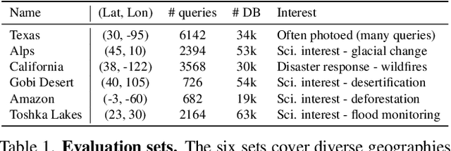
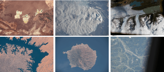
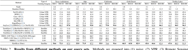
Astronaut photography, spanning six decades of human spaceflight, presents a unique Earth observations dataset with immense value for both scientific research and disaster response. Despite its significance, accurately localizing the geographical extent of these images, crucial for effective utilization, poses substantial challenges. Current manual localization efforts are time-consuming, motivating the need for automated solutions. We propose a novel approach - leveraging image retrieval - to address this challenge efficiently. We introduce innovative training techniques, including Year-Wise Data Augmentation and a Neutral-Aware Multi-Similarity Loss, which contribute to the development of a high-performance model, EarthLoc. We develop six evaluation datasets and perform a comprehensive benchmark comparing EarthLoc to existing methods, showcasing its superior efficiency and accuracy. Our approach marks a significant advancement in automating the localization of astronaut photography, which will help bridge a critical gap in Earth observations data. Code and datasets are available at https://github.com/gmberton/EarthLoc