Yuxiao Ren
GPRInvNet: Deep Learning-Based Ground Penetrating Radar Data Inversion for Tunnel Lining
Dec 13, 2019


Abstract:A DNN architecture called GPRInvNet is proposed to tackle the challenge of mapping Ground Penetrating Radar (GPR) B-Scan data to complex permittivity maps of subsurface structure. GPRInvNet consists of a trace-to-trace encoder and a decoder. It is specially designed to take account of the characteristics of GPR inversion when faced with complex GPR B-Scan data as well as addressing the spatial alignment issue between time-series B-Scan data and spatial permittivity maps. It fuses features from several adjacent traces on the B-Scan data to enhance each trace, and then further condense the features of each trace separately. The sensitive zone on the permittivity map spatially aligned to the enhanced trace is reconstructed accurately. GPRInvNet has been utilized to reconstruct the permittivity map of tunnel linings. A diverse range of dielectric models of tunnel lining containing complex defects has been reconstructed using GPRInvNet, and results demonstrate that GPRInvNet is capable of effectively reconstructing complex tunnel lining defects with clear boundaries. Comparative results with existing baseline methods also demonstrate the superiority of the GPRInvNet. To generalize GPRInvNet to real GPR data, we integrated background noise patches recorded form a practical model testing into synthetic GPR data to train GPRInvNet. The model testing has been conducted for validation, and experimental results show that GPRInvNet achieves satisfactory results on real data.
Deep Learning Inversion of Electrical Resistivity Data
Apr 10, 2019


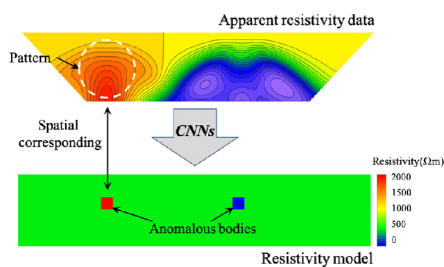
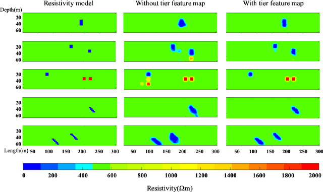
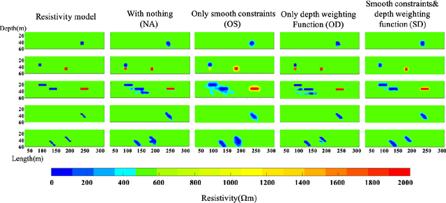
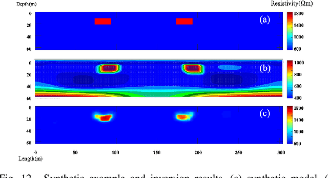
Abstract:The inverse problem of electrical resistivity surveys (ERS) is difficult because of its nonlinear and ill-posed nature. For this task, traditional linear inversion methods still face challenges such as sub-optimal approximation and initial model selection. Inspired by the remarkable non-linear mapping ability of deep learning approaches, in this paper we propose to build the mapping from apparent resistivity data (input) to resistivity model (output) directly by convolutional neural networks (CNNs). However, the vertically varying characteristic of patterns in the apparent resistivity data may cause ambiguity when using CNNs with the weight sharing and effective receptive field properties. To address the potential issue, we supply an additional tier feature map to CNNs to help it get aware of the relationship between input and output. Based on the prevalent U-Net architecture, we design our network (ERSInvNet) which can be trained end-to-end and reach real-time inference during testing. We further introduce depth weighting function and smooth constraint into loss function to improve inversion accuracy for the deep region and suppress false anomalies. Four groups of experiments are considered to demonstrate the feasibility and efficiency of the proposed methods. According to the comprehensive qualitative analysis and quantitative comparison, ERSInvNet with tier feature map, smooth constraints and depth weighting function together achieve the best performance.
Deep learning Inversion of Seismic Data
Jan 23, 2019


Abstract:In this paper, we propose a new method to tackle the mapping challenge from time-series data to spatial image in the field of seismic exploration, i.e., reconstructing the velocity model directly from seismic data by deep neural networks (DNNs). The conventional way to address this ill-posed seismic inversion problem is through iterative algorithms, which suffer from poor nonlinear mapping and strong non-uniqueness. Other attempts may either import human intervention errors or underuse seismic data. The challenge for DNNs mainly lies in the weak spatial correspondence, the uncertain reflection-reception relationship between seismic data and velocity model as well as the time-varying property of seismic data. To approach these challenges, we propose an end-to-end Seismic Inversion Networks (SeisInvNet for short) with novel components to make the best use of all seismic data. Specifically, we start with every seismic trace and enhance it with its neighborhood information, its observation setup and global context of its corresponding seismic profile. Then from enhanced seismic traces, the spatially aligned feature maps can be learned and further concatenated to reconstruct velocity model. In general, we let every seismic trace contribute to the reconstruction of the whole velocity model by finding spatial correspondence. The proposed SeisInvNet consistently produces improvements over the baselines and achieves promising performance on our proposed SeisInv dataset according to various evaluation metrics, and the inversion results are more consistent with the target from the aspects of velocity value, subsurface structure and geological interface. In addition to the superior performance, the mechanism is also carefully discussed, and some potential problems are identified for further study.
 Add to Chrome
 Add to Firefox
 Add to Edge