 Add to Chrome
 Add to Firefox
 Add to Edge
It is not always greener on the other side: Greenery perception across demographics and personalities in multiple cities
Dec 19, 2025Quantifying and assessing urban greenery is consequential for planning and development, reflecting the everlasting importance of green spaces for multiple climate and well-being dimensions of cities. Evaluation can be broadly grouped into objective (e.g., measuring the amount of greenery) and subjective (e.g., polling the perception of people) approaches, which may differ -- what people see and feel about how green a place is might not match the measurements of the actual amount of vegetation. In this work, we advance the state of the art by measuring such differences and explaining them through human, geographic, and spatial dimensions. The experiments rely on contextual information extracted from street view imagery and a comprehensive urban visual perception survey collected from 1,000 people across five countries with their extensive demographic and personality information. We analyze the discrepancies between objective measures (e.g., Green View Index (GVI)) and subjective scores (e.g., pairwise ratings), examining whether they can be explained by a variety of human and visual factors such as age group and spatial variation of greenery in the scene. The findings reveal that such discrepancies are comparable around the world and that demographics and personality do not play a significant role in perception. Further, while perceived and measured greenery correlate consistently across geographies (both where people and where imagery are from), where people live plays a significant role in explaining perceptual differences, with these two, as the top among seven, features that influences perceived greenery the most. This location influence suggests that cultural, environmental, and experiential factors substantially shape how individuals observe greenery in cities.
It's not you, it's me -- Global urban visual perception varies across demographics and personalities
May 19, 2025Understanding people's preferences and needs is crucial for urban planning decisions, yet current approaches often combine them from multi-cultural and multi-city populations, obscuring important demographic differences and risking amplifying biases. We conducted a large-scale urban visual perception survey of streetscapes worldwide using street view imagery, examining how demographics -- including gender, age, income, education, race and ethnicity, and, for the first time, personality traits -- shape perceptions among 1,000 participants, with balanced demographics, from five countries and 45 nationalities. This dataset, introduced as Street Perception Evaluation Considering Socioeconomics (SPECS), exhibits statistically significant differences in perception scores in six traditionally used indicators (safe, lively, wealthy, beautiful, boring, and depressing) and four new ones we propose (live nearby, walk, cycle, green) among demographics and personalities. We revealed that location-based sentiments are carried over in people's preferences when comparing urban streetscapes with other cities. Further, we compared the perception scores based on where participants and streetscapes are from. We found that an off-the-shelf machine learning model trained on an existing global perception dataset tends to overestimate positive indicators and underestimate negative ones compared to human responses, suggesting that targeted intervention should consider locals' perception. Our study aspires to rectify the myopic treatment of street perception, which rarely considers demographics or personality traits.
Texture2LoD3: Enabling LoD3 Building Reconstruction With Panoramic Images
Apr 07, 2025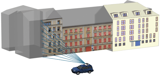
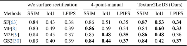
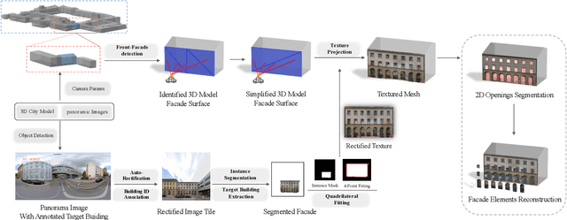
Despite recent advancements in surface reconstruction, Level of Detail (LoD) 3 building reconstruction remains an unresolved challenge. The main issue pertains to the object-oriented modelling paradigm, which requires georeferencing, watertight geometry, facade semantics, and low-poly representation -- Contrasting unstructured mesh-oriented models. In Texture2LoD3, we introduce a novel method leveraging the ubiquity of 3D building model priors and panoramic street-level images, enabling the reconstruction of LoD3 building models. We observe that prior low-detail building models can serve as valid planar targets for ortho-rectifying street-level panoramic images. Moreover, deploying segmentation on accurately textured low-level building surfaces supports maintaining essential georeferencing, watertight geometry, and low-poly representation for LoD3 reconstruction. In the absence of LoD3 validation data, we additionally introduce the ReLoD3 dataset, on which we experimentally demonstrate that our method leads to improved facade segmentation accuracy by 11% and can replace costly manual projections. We believe that Texture2LoD3 can scale the adoption of LoD3 models, opening applications in estimating building solar potential or enhancing autonomous driving simulations. The project website, code, and data are available here: https://wenzhaotang.github.io/Texture2LoD3/.
ZenSVI: An Open-Source Software for the Integrated Acquisition, Processing and Analysis of Street View Imagery Towards Scalable Urban Science
Dec 24, 2024Street view imagery (SVI) has been instrumental in many studies in the past decade to understand and characterize street features and the built environment. Researchers across a variety of domains, such as transportation, health, architecture, human perception, and infrastructure have employed different methods to analyze SVI. However, these applications and image-processing procedures have not been standardized, and solutions have been implemented in isolation, often making it difficult for others to reproduce existing work and carry out new research. Using SVI for research requires multiple technical steps: accessing APIs for scalable data collection, preprocessing images to standardize formats, implementing computer vision models for feature extraction, and conducting spatial analysis. These technical requirements create barriers for researchers in urban studies, particularly those without extensive programming experience. We develop ZenSVI, a free and open-source Python package that integrates and implements the entire process of SVI analysis, supporting a wide range of use cases. Its end-to-end pipeline includes downloading SVI from multiple platforms (e.g., Mapillary and KartaView) efficiently, analyzing metadata of SVI, applying computer vision models to extract target features, transforming SVI into different projections (e.g., fish-eye and perspective) and different formats (e.g., depth map and point cloud), visualizing analyses with maps and plots, and exporting outputs to other software tools. We demonstrate its use in Singapore through a case study of data quality assessment and clustering analysis in a streamlined manner. Our software improves the transparency, reproducibility, and scalability of research relying on SVI and supports researchers in conducting urban analyses efficiently. Its modular design facilitates extensions and unlocking new use cases.