Sumit Mishra
Road Redesign Technique Achieving Enhanced Road Safety by Inpainting with a Diffusion Model
Feb 15, 2023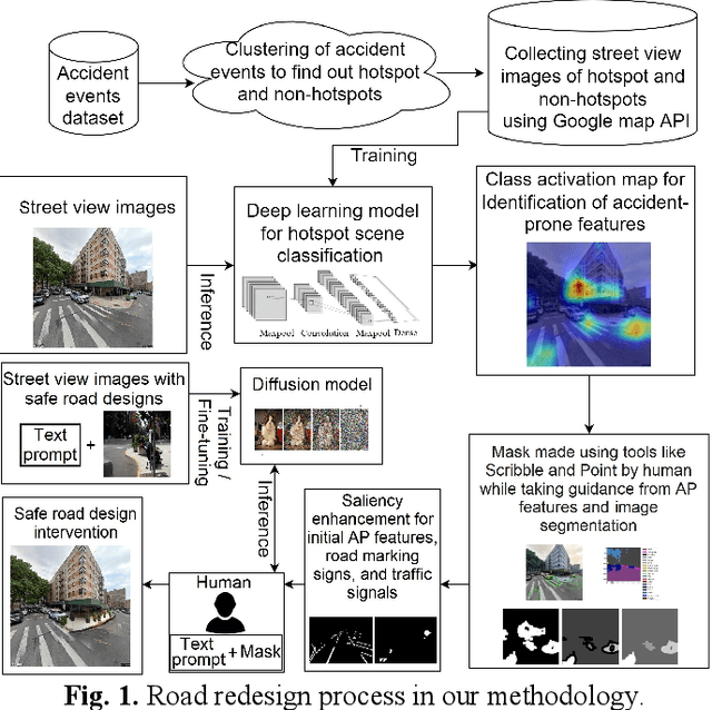

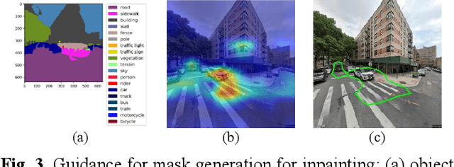
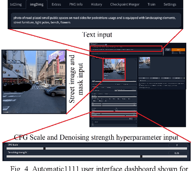
Abstract:Road infrastructure can affect the occurrence of road accidents. Therefore, identifying roadway features with high accident probability is crucial. Here, we introduce image inpainting that can assist authorities in achieving safe roadway design with minimal intervention in the current roadway structure. Image inpainting is based on inpainting safe roadway elements in a roadway image, replacing accident-prone (AP) features by using a diffusion model. After object-level segmentation, the AP features identified by the properties of accident hotspots are masked by a human operator and safe roadway elements are inpainted. With only an average time of 2 min for image inpainting, the likelihood of an image being classified as an accident hotspot drops by an average of 11.85%. In addition, safe urban spaces can be designed considering human factors of commuters such as gaze saliency. Considering this, we introduce saliency enhancement that suggests chrominance alteration for a safe road view.
RELMOBNET: A Robust Two-Stage End-To-End Training Approach For MOBILENETV3 Based Relative Camera Pose Estimation
Feb 25, 2022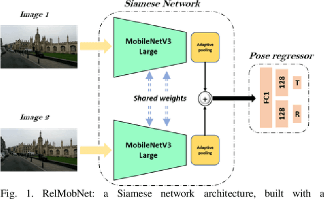
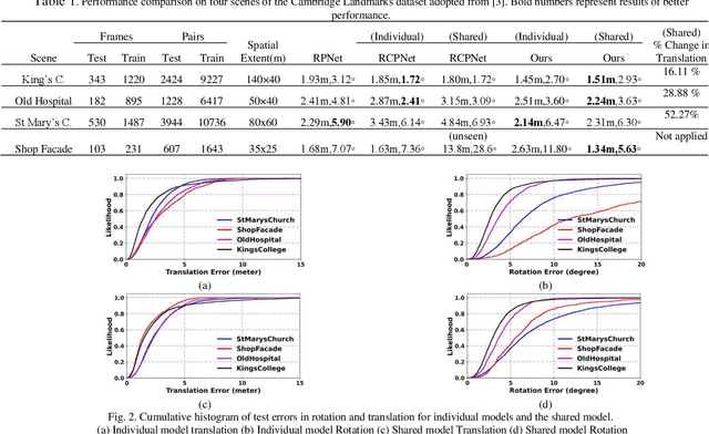
Abstract:Relative camera pose estimation plays a pivotal role in dealing with 3D reconstruction and visual localization. To address this, we propose a Siamese network based on MobileNetV3-Large for an end-to-end relative camera pose regression independent of camera parameters. The proposed network uses pair of images taken at different locations in the same scene to estimate the 3D translation vector and rotation vector in unit quaternion. To increase the generality of the model, rather than training it for a single scene, data for four scenes are combined to train a single universal model to estimate the relative pose. Further for independency of hyperparameter weighing between translation and rotation loss is not used. Instead we use the novel two-stage training procedure to learn the balance implicitly with faster convergence. We compare the results obtained with the Cambridge Landmarks dataset, comprising of different scenes, with existing CNN-based regression methods as baselines, e.g., RPNet and RCPNet. The findings indicate that, when compared to RCPNet, proposed model improves the estimation of the translation vector by a percentage change of 16.11%, 28.88%, 52.27% on the Kings College, Old Hospital, St Marys Church scenes from Cambridge Landmarks dataset, respectively.
Sensing accident-prone features in urban scenes for proactive driving and accident prevention
Feb 25, 2022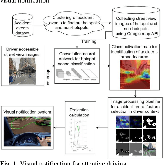
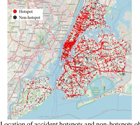

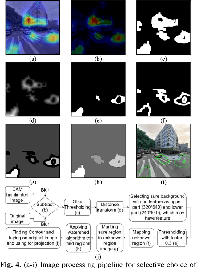
Abstract:In urban cities, visual information along and on roadways is likely to distract drivers and leads to missing traffic signs and other accident-prone features. As a solution to avoid accidents due to missing these visual cues, this paper proposes a visual notification of accident-prone features to drivers, based on real-time images obtained via dashcam. For this purpose, Google Street View images around accident hotspots (areas of dense accident occurrence) identified by accident dataset are used to train a family of deep convolutional neural networks (CNNs). Trained CNNs are able to detect accident-prone features and classify a given urban scene into an accident hotspot and a non-hotspot (area of sparse accident occurrence). For given accident hotspot, the trained CNNs can classify it into an accident hotspot with the accuracy up to 90%. The capability of detecting accident-prone features by the family of CNNs is analyzed by a comparative study of four different class activation map (CAM) methods, which are used to inspect specific accident-prone features causing the decision of CNNs, and pixel-level object class classification. The outputs of CAM methods are processed by an image processing pipeline to extract only the accident-prone features that are explainable to drivers with the help of visual notification system. To prove the efficacy of accident-prone features, an ablation study is conducted. Ablation of accident-prone features taking 7.7%, on average, of total area in each image sample causes up to 13.7% more chance of given area to be classified as a non-hotspot.
Socially acceptable route planning and trajectory behavior analysis of personal mobility device for mobility management with improved sensing
Dec 07, 2021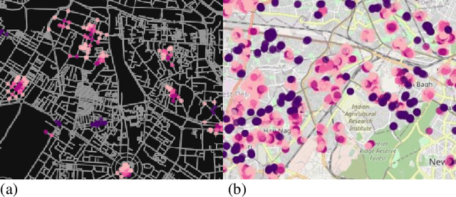


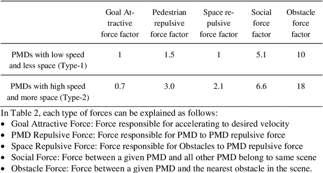
Abstract:In urban cities, with increasing acceptability of shared spaces used by pedestrians and personal mobility devices (PMDs), there is need for pragmatic socially ac-ceptable path planning and navigation management policies. Hence, we propose a socially acceptable global route planner and assess the legibility of the resulting global route. Our approach proposed for choosing global route avoids streets penetrating shared spaces and main routes with high probability of dense usage. The experimental study shows that socially acceptable routes can be effectively found with an average of 10 % increment of route length with optimal hyperpa-rameters. This helps PMDs to reach the goal while taking a socially acceptable and safe route with minimal interaction of different PMDs and pedestrians. When PMDs interact with pedestrians and other types of PMDs in shared spaces, mi-cro-mobility simulations are of prime usage for acceptable and safe navigation policy. Social force models being state of the art for pedestrian simulation are cal-ibrated for capturing random movements of pedestrian behavior. Social force model with calibration can imitate the required behavior of PMDs in a pedestrian mix navigation scheme. Based on calibrated models, simulations on shared space links and gate structures are performed to assist policies related to deciding wait-ing and stopping time. Also, based on simulated PMDs interaction with pedestri-ans, location data with finer resolution can be obtained if the resolution of GPS sensor is 0.2 m or less. This will help in formalizing better modelling and hence better micro-mobility policies.
 Add to Chrome
 Add to Firefox
 Add to Edge