Sizhuo Li
Get Your Embedding Space in Order: Domain-Adaptive Regression for Forest Monitoring
May 01, 2024


Abstract:Image-level regression is an important task in Earth observation, where visual domain and label shifts are a core challenge hampering generalization. However, cross-domain regression with remote sensing data remains understudied due to the absence of suited datasets. We introduce a new dataset with aerial and satellite imagery in five countries with three forest-related regression tasks. To match real-world applicative interests, we compare methods through a restrictive setup where no prior on the target domain is available during training, and models are adapted with limited information during testing. Building on the assumption that ordered relationships generalize better, we propose manifold diffusion for regression as a strong baseline for transduction in low-data regimes. Our comparison highlights the comparative advantages of inductive and transductive methods in cross-domain regression.
Benchmarking Individual Tree Mapping with Sub-meter Imagery
Nov 14, 2023Abstract:There is a rising interest in mapping trees using satellite or aerial imagery, but there is no standardized evaluation protocol for comparing and enhancing methods. In dense canopy areas, the high variability of tree sizes and their spatial proximity makes it arduous to define the quality of the predictions. Concurrently, object-centric approaches such as bounding box detection usuallyperform poorly on small and dense objects. It thus remains unclear what is the ideal framework for individual tree mapping, in regards to detection and segmentation approaches, convolutional neural networks and transformers. In this paper, we introduce an evaluation framework suited for individual tree mapping in any physical environment, with annotation costs and applicative goals in mind. We review and compare different approaches and deep architectures, and introduce a new method that we experimentally prove to be a good compromise between segmentation and detection.
Mega-cities dominate China's urban greening
Jul 03, 2023


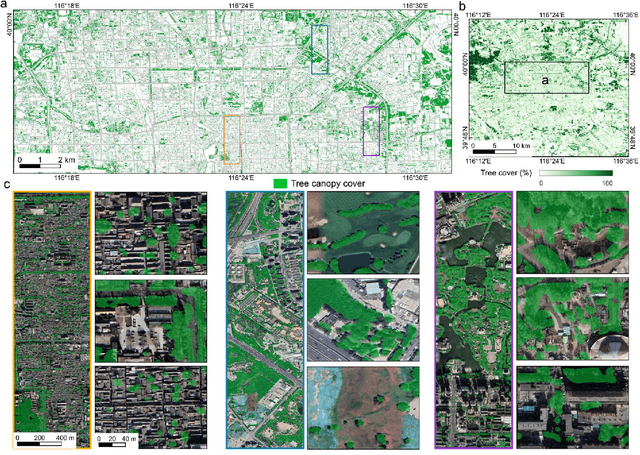
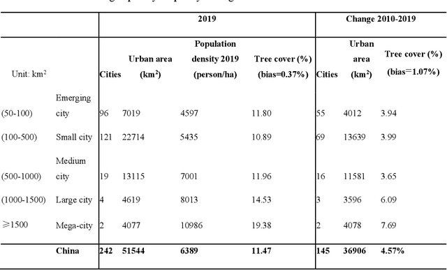
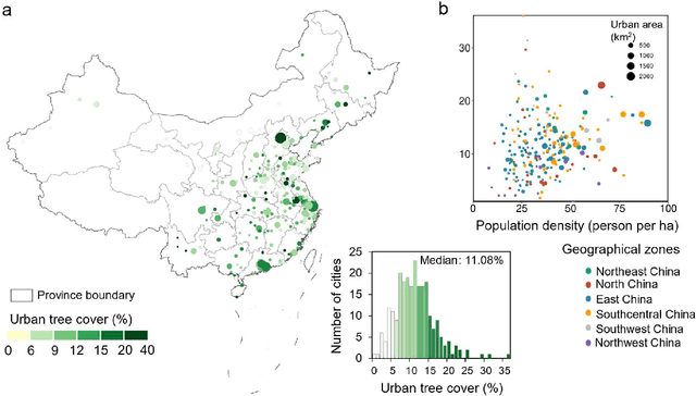
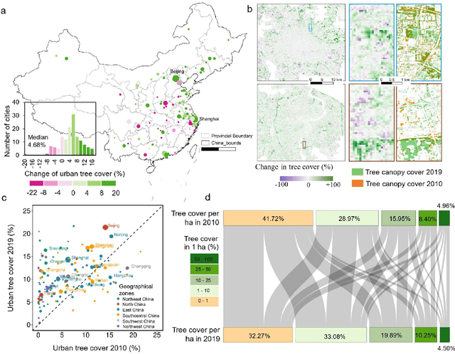
Abstract:Trees play a crucial role in urban environments, offering various ecosystem services that contribute to public health and human well-being. China has initiated a range of urban greening policies over the past decades, however, monitoring their impact on urban tree dynamics at a national scale has proven challenging. In this study, we deployed nano-satellites to quantify urban tree coverage in all major Chinese cities larger than 50 km2 in 2010 and 2019. Our findings indicate that approximately 6000 km2 (11%) of urban areas were covered by trees in 2019, and 76% of these cities experienced an increase in tree cover compared to 2010. Notably, the increase in tree cover in mega-cities such as Beijing, and Shanghai was approximately twice as large as in most other cities (7.69% vs 3.94%). The study employs a data-driven approach towards assessing urban tree cover changes in relation to greening policies, showing clear signs of tree cover increases but also suggesting an uneven implementation primarily benefiting a few mega-cities.
 Add to Chrome
 Add to Firefox
 Add to Edge