Rohini Pande
Discovering Hidden Pollution Hotspots Using Sparse Sensor Measurements
Oct 05, 2024Abstract:Effective air pollution management in urban areas relies on both monitoring and mitigation strategies, yet high costs often limit sensor networks to a few key pollution hotspots. In this paper, we show that New Delhi's public sensor network is insufficient for identifying all pollution hotspots. To address this, we augmented the city's network with 28 low-cost sensors, monitoring PM 2.5 concentrations over 30 months (May 2018 to November 2020). Our analysis uncovered 189 additional hotspots, supplementing the 660 already detected by the government network. We observed that Space-Time Kriging with limited but accurate sensor data provides a more robust and generalizable approach for identifying these hotspots, as compared to deep learning models that require large amounts of fine-grained multi-modal data (emissions inventory, meteorology, etc.) which was not reliably, frequently and accurately available in the New Delhi context. Using Space-Time Kriging, we achieved 98% precision and 95.4% recall in detecting hotspots with 50% sensor failure. Furthermore, this method proved effective in predicting hotspots in areas without sensors, achieving 95.3% precision and 88.5% recall in the case of 50% missing sensors. Our findings revealed that a significant portion of New Delhi's population, around 23 million people, was exposed to pollution hotspots for at least half of the study period. We also identified areas beyond the reach of the public sensor network that should be prioritized for pollution control. These results highlight the need for more comprehensive monitoring networks and suggest Space-Time Kriging as a viable solution for cities facing similar resource constraints.
Detecting Crop Burning in India using Satellite Data
Sep 21, 2022


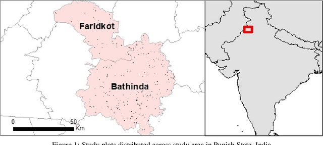
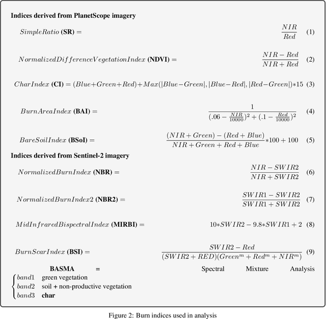
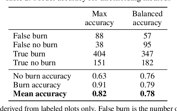
Abstract:Crop residue burning is a major source of air pollution in many parts of the world, notably South Asia. Policymakers, practitioners and researchers have invested in both measuring impacts and developing interventions to reduce burning. However, measuring the impacts of burning or the effectiveness of interventions to reduce burning requires data on where burning occurred. These data are challenging to collect in the field, both in terms of cost and feasibility. We take advantage of data from ground-based monitoring of crop residue burning in Punjab, India to explore whether burning can be detected more effectively using accessible satellite imagery. Specifically, we used 3m PlanetScope data with high temporal resolution (up to daily) as well as publicly-available Sentinel-2 data with weekly temporal resolution but greater depth of spectral information. Following an analysis of the ability of different spectral bands and burn indices to separate burned and unburned plots individually, we built a Random Forest model with those determined to provide the greatest separability and evaluated model performance with ground-verified data. Our overall model accuracy of 82-percent is favorable given the challenges presented by the measurement. Based on insights from this process, we discuss technical challenges of detecting crop residue burning from satellite imagery as well as challenges to measuring impacts, both of burning and of policy interventions.
 Add to Chrome
 Add to Firefox
 Add to Edge