 Add to Chrome
 Add to Firefox
 Add to Edge
Quadratic Kalman Filter for Elliptical Extended Object Tracking based on Decoupling State Components
Dec 16, 2025Extended object tracking involves estimating both the physical extent and kinematic parameters of a target object, where typically multiple measurements are observed per time step. In this article, we propose a deterministic closed-form elliptical extended object tracker, based on decoupling of the kinematics, orientation, and axis lengths. By disregarding potential correlations between these state components, fewer approximations are required for the individual estimators than for an overall joint solution. The resulting algorithm outperforms existing algorithms, reaching the accuracy of sampling-based procedures. Additionally, a batch-based variant is introduced, yielding highly efficient computation while outperforming all comparable state-of-the-art algorithms. This is validated both by a simulation study using common models from literature, as well as an extensive quantitative evaluation on real automotive radar data.
Odyssey: An Automotive Lidar-Inertial Odometry Dataset for GNSS-denied situations
Dec 16, 2025
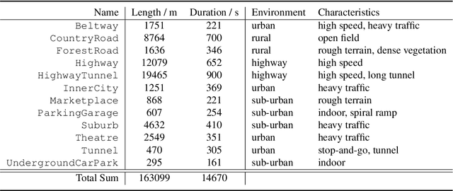
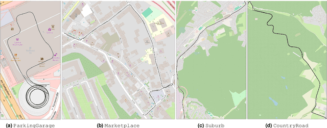

The development and evaluation of Lidar-Inertial Odometry (LIO) and Simultaneous Localization and Mapping (SLAM) systems requires a precise ground truth. The Global Navigation Satellite System (GNSS) is often used as a foundation for this, but its signals can be unreliable in obstructed environments due to multi-path effects or loss-of-signal. While existing datasets compensate for the sporadic loss of GNSS signals by incorporating Inertial Measurement Unit (IMU) measurements, the commonly used Micro-Electro-Mechanical Systems (MEMS) or Fiber Optic Gyroscope (FOG)-based systems do not permit the prolonged study of GNSS-denied environments. To close this gap, we present Odyssey, a LIO dataset with a focus on GNSS-denied environments such as tunnels and parking garages as well as other underrepresented, yet ubiquitous situations such as stop-and-go-traffic, bumpy roads and wide open fields. Our ground truth is derived from a navigation-grade Inertial Navigation System (INS) equipped with a Ring Laser Gyroscope (RLG), offering exceptional bias stability characteristics compared to IMUs used in existing datasets and enabling the prolonged and accurate study of GNSS-denied environments. This makes Odyssey the first publicly available dataset featuring a RLG-based INS. Besides providing data for LIO, we also support other tasks, such as place recognition, through the threefold repetition of all trajectories as well as the integration of external mapping data by providing precise geodetic coordinates. All data, dataloader and other material is available online at https://odyssey.uni-goettingen.de/ .
Lidar-only Odometry based on Multiple Scan-to-Scan Alignments over a Moving Window
Mar 27, 2025Lidar-only odometry considers the pose estimation of a mobile robot based on the accumulation of motion increments extracted from consecutive lidar scans. Many existing approaches to the problem use a scan-to-map registration, which neglects the accumulation of errors within the maintained map due to drift. Other methods use a refinement step that jointly optimizes the local map on a feature basis. We propose a solution that avoids this by using multiple independent scan-to-scan Iterative Closest Points (ICP) registrations to previous scans in order to derive constraints for a pose graph. The optimization of the pose graph then not only yields an accurate estimate for the latest pose, but also enables the refinement of previous scans in the optimization window. By avoiding the need to recompute the scan-to-scan alignments, the computational load is minimized. Extensive evaluation on the public KITTI and MulRan datasets as well as on a custom automotive lidar dataset is carried out. Results show that the proposed approach achieves state-of-the-art estimation accuracy, while alleviating the mentioned issues.
Continuous Herded Gibbs Sampling
Jun 11, 2021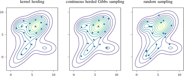
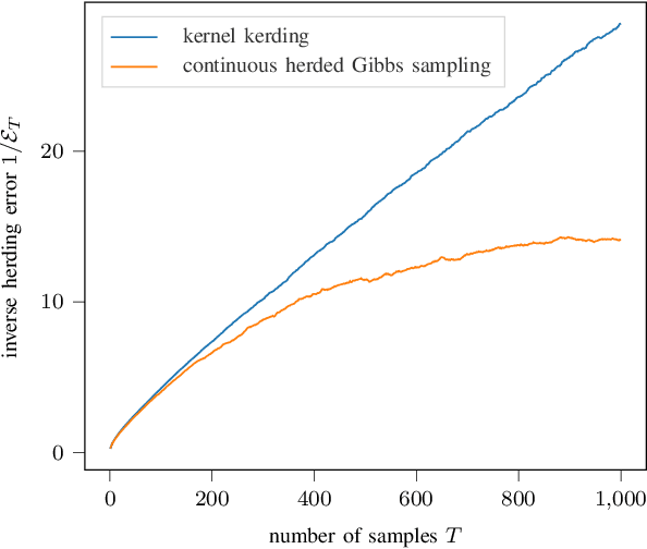

Herding is a technique to sequentially generate deterministic samples from a probability distribution. In this work, we propose a continuous herded Gibbs sampler, that combines kernel herding on continuous densities with Gibbs sampling. Our algorithm allows for deterministically sampling from high-dimensional multivariate probability densities, without directly sampling from the joint density. Experiments with Gaussian mixture densities indicate that the L2 error decreases similarly to kernel herding, while the computation time is significantly lower, i.e., linear in the number of dimensions.
Optimal Fusion of Elliptic Extended Target Estimates based on the Wasserstein Distance
Apr 01, 2019
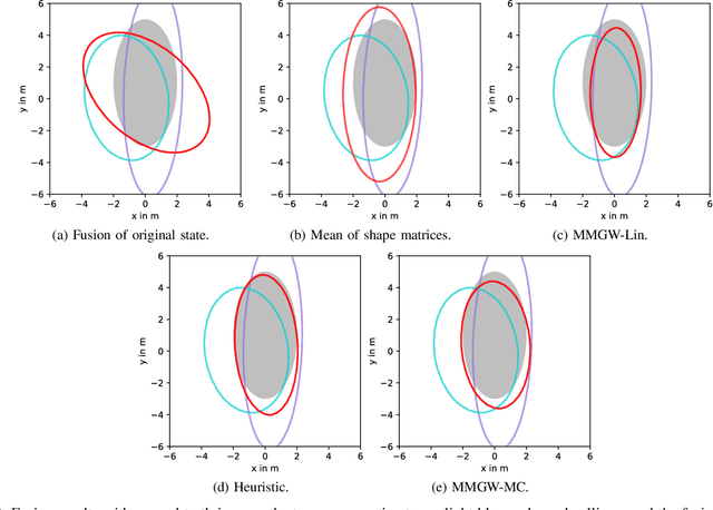
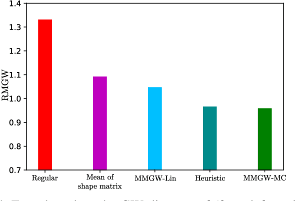
This paper considers the fusion of multiple estimates of a spatially extended object, where the object extent is modeled as an ellipse that is parameterized by the orientation and semi-axes lengths. For this purpose, we propose a novel systematic approach that employs a distance measure for ellipses, i.e., the Gaussian Wasserstein distance, as a cost function. We derive an explicit expression for the Minimium Mean Gaussian Wasserstein distance (MMGW) estimate. Based on the concept of a MMGW estimator, we develop efficient methods for the fusion of extended target estimates. The proposed fusion methods are evaluated in a simulated experiment and the benefits of the novel methods are discussed.
Extended Object Tracking: Introduction, Overview and Applications
Feb 21, 2017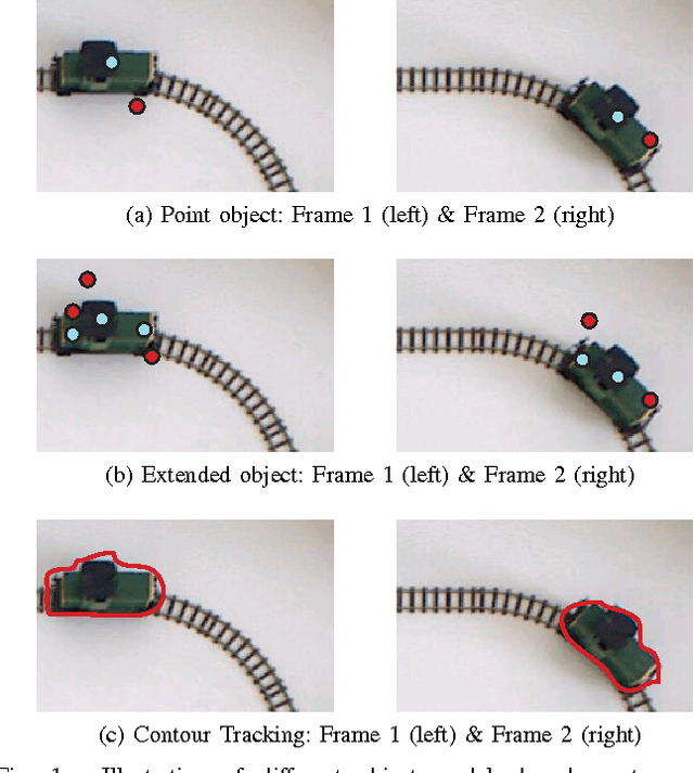
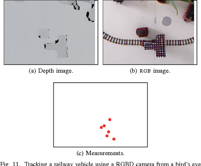
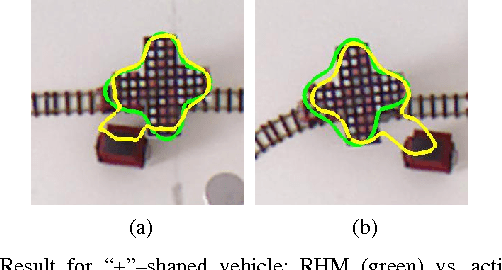
This article provides an elaborate overview of current research in extended object tracking. We provide a clear definition of the extended object tracking problem and discuss its delimitation to other types of object tracking. Next, different aspects of extended object modelling are extensively discussed. Subsequently, we give a tutorial introduction to two basic and well used extended object tracking approaches - the random matrix approach and the Kalman filter-based approach for star-convex shapes. The next part treats the tracking of multiple extended objects and elaborates how the large number of feasible association hypotheses can be tackled using both Random Finite Set (RFS) and Non-RFS multi-object trackers. The article concludes with a summary of current applications, where four example applications involving camera, X-band radar, light detection and ranging (lidar), red-green-blue-depth (RGB-D) sensors are highlighted.
* 30 pages, 19 figures